Swamp Creek

Sunday 2 August: Swamp Creek Nature Reserve – S/R,X. An afternoon walk to explore a small nature reserve near Uriarra Crossing, through grasslands and along the creek bed, with some optional rock scrambling at the upper end of the reserve to check out what looks, on Google Earth, like a small gorge with a swimming hole. I am using this walk as a reconnaissance for a kids’ summer trip, but Totally Topo followers will be interested in it for other reasons. 6 km, main ascent 60 metres up a creek-side hill, relaxed pace. No need to book but let me know if you can offer or need a lift. Meet at Uriarra Crossing, in the bitumen car park on the west side of the Murrumbidgee, just upstream from the bridge, at 1 pm. Phone me on my mobile if you can’t find the carpark. Map: Umburra. Leader: Linda G. Transport: $3-4 if shared.
8 of us met in the Uriarra West car park.
Summary
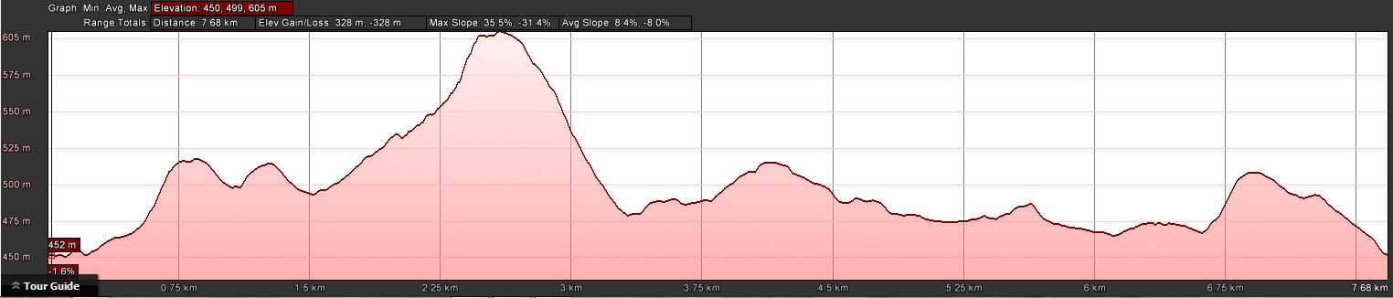
Distance: 7.8km | Climb: 330m | Time: 1.10pm-4.30pm (3hrs 20mins), including 15 mins of breaks | Grading: S/M-R; M(9)
Track Map
Track
Profile
Photographs
Photographs are available, where you can start a large sized slideshow.
Video
Waypoint and Track Files
Download the .gpx file. (Right click, Save Link As…, Save – if you want to use it.)
Download the .kml file.
Track Notes
A quick exit from church, a hurried lunch and a quick drive to the meet point. A showery day.
The Murrumbidgee River was swollen and running fast, Swamp Creek likewise and nearly up over the ford so the Fairlight Road was closed. From a previous trip on 9 Apr 13, I knew that the south bank of Swamp Creek would be the easier walking. But our fearless leader also knew that Uriarra Creek would be up, so we headed up Fairlight Road a bit to get above the scrubby true left bank of the creek. A huff and a puff up to a knoll. On its west side the weather came in from the Brindabellas, so it was coats on.
Linda was then heading closer down to the creek and she very kindly gave me the nod to leave the party and head for geocache GC5950Y Swampy Sights II, about 1.3 crowlometres away. Open going, with a feeder drainage line to negotiate which was running briskly. It rained. Circled the top of another feeder and onto the side of the knoll with the cache. A find and a log. Two eagles soared nearby.
I came away from the cache to the north which gave the best line and was going to head east back to my car, but saw Linda’s party of 3 (4 had returned) down by Swamp Creek. So I did a big u-turn and trundled down the hill to Swamp Creek.
A lovely surprise down next to the raging creek – a pair of wombats, mother and child, allowed me to get quite close and didn’t mind me taking a photograph or several. I scurried along and caught the others.
We entered the downstream end of a bit of a gorge and hit the blackberries. Some pads allowed us to approach the cascades and pool that Linda was looking for. Arvo tea (thanks Imaina!).
Returning to the open area beside Swamp Creek where I’d seen the wombats, our adventurous leader did a little recce across a log she’d spotted and found us a crossing of Uriarra Creek. (I think she is a secret geocacher and knew I needed to get onto the other side of Swamp Creek 😉 .) She returned with good news and we all balanced across the log and walked to very near the confluence of Uriarra and Swamp Creek. Here, the first log took us to an island, then a log jam got us across the other arm of Uriarra Creek.
Easy going along a fence beside the creek. At a suitable point I dropped my gear (thanks for bringing it on Linda), got over the fence and eventually found GC5950F Swampy Sights I.
Fence lines and a gate got me back to the Uriarra Road. I think the others came cross country.
Thanks Linda and all. We carped the diem.
Party
8 walkers – Rupert B, Stan G, Linda G (leader), Pam MacD, Keith S, Doug W, Imaina W, me.