Returning via the slabs

Bonnum Pic – M/M. This narrow ridge with huge drops and views either side is in Nattai National Park, overlooking the Wollondilly River. The plateau supports a variety of shrubs and plants. Fabulous runs of open rocks and excellent sandstone features. Although it might disappoint some we will not continue north from the Bonnum Pic map-marked trig area across the slots and to the nose of the feature. This would involve lowering ourselves on a hand-line down a rock face and return. Around 16km and 400m climb. Map: Hilltop. Leader: Phillip S. Transport: $160 per car ($40 – $50 per person). Booking: Please book by email before 2 pm Monday 1 August.
8 of us met at the Lyneham Netball Courts at 7am.
Further Information
A different approach to Wanganderry Rd this time, compared with 31 Aug 10. The same as 6 Aug 13 (when I dozed all the way there and back) – to Berrima, a little along the Old Hume Highway, then left into Greenhills Rd, left into Wombeyan Caves Rd, right into Wanganderry Rd.
Summary
Distance: 14.4km | Climb: 300m | Time: 9.30am – 3.15pm (5hrs 45mins), including 30 mins of breaks | Grading: M/M; M(10)
Photographs
Photographs are available, where you can start a large sized slideshow. They are of particularly poor quality, as they were taken with my GPSr (not its fault), it was raining some of the time and I couldn’t see what I was photographing all the time.
Waypoint and Track Files
Download the .gpx file. (Right click, Save Link As…, Save – if you want to use it.)
To use in Google Earth, do File, Open… and select Gps or All files as the File Type.
Track Notes
If I was leading the walk it wouldn’t have happened. Hats off to Phillip for getting us out. Always good to test your wet weather gear – my preferred style of long coat, shorts and gaiters (learned from Rupert B in Tasmania when I began to walk) still wins over short rain jacket and overpants, IMHO. I stayed dry, except for 15cm of knee. The weather was showery and forecast max 9ºC, a little cooler in the breeze. Wetter than Canberra.
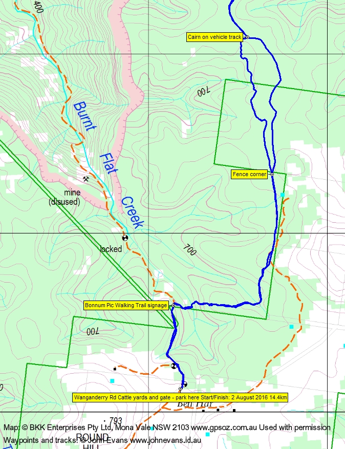
After leaving north Canberra at 7am and a lineup with heaps of school kids at Maccas, we were walking by 9.30am. Down the fire trail from the cattle yards to the Bonnum Pic Walking Trail signage, then through the wet gully following the totems and tapes through the top of Burnt Flat Creek to the fence line and so to the fence corner.
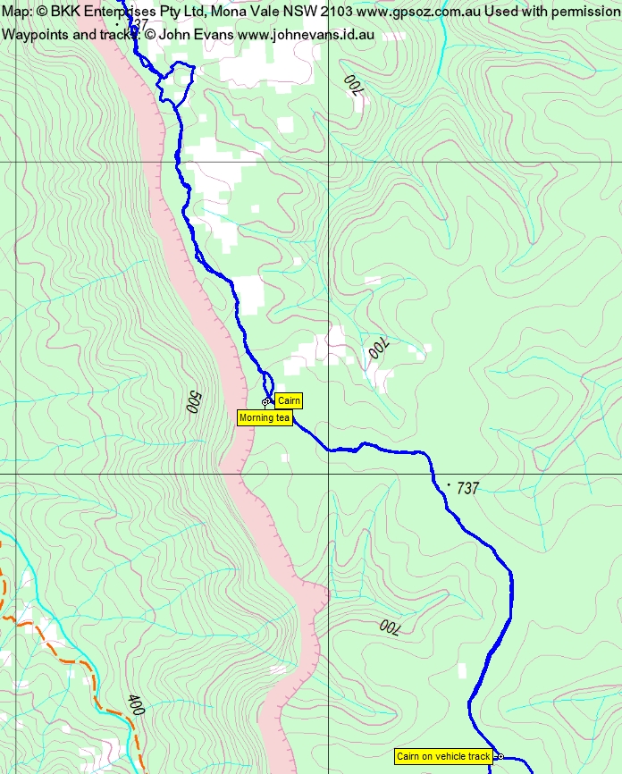
You can see the green boundary of the private block in the Track 1 map segment taken (with permission) from the OZraser Hilltop map. There is a lot of clearing going on here and we missed the vehicle track entry. But lovely light going and the flowering shrubs and wattles immediately appeared. We soon came to the vehicle track and picked up the required footpad. A hasty morning tea was taken when we reached the cliff top.
Most of us took a turn at following, losing and regaining the cairned footpad as we headed north. Misty views to the west down over the Wollondilly River valley. Lovely runs of sandstone with weird holes and shapes were traversed, along with cliff top sandy areas.
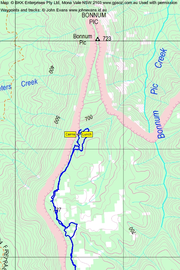
We regained the cairned route near our northern most point. We believed we saw the next cairn up a wet and slippery rock scramble, although previous trippers in this area couldn’t remember such a scramble. This was deemed not doable in today’s conditions and I fully supported (and contributed to) the walk leader’s decision to call it a day here. Lunch was called. Being a gentleman of advanced years, probably with an enlarged you-know-what, I took a little solo trip north and closer to the cliff edge where I photographed the sediment layer – see post script.
The trip in was 7.3km in 2hrs 55mins (including 10mins morning tea).
Our trip out was a little more direct, although we still managed a little ‘balloon’ just south of SH737. Another chance to walk the sandstone runs, catch glimpses of the valley 200m below to the west and to anticipate the end of winter, due to the lovely new flowers. 7.0km in 2hrs 15mins.
Wanganderry Rd was a little more slippery driving out and this time we stopped at the east side, going south Maccas, with quicker service.
Thanks all. Great trip, Phillip – you’re a better man than me.
Track Maps
Track overview

Track 1
Track 2
Track 3
Party
8 walkers – Melinda B, Eric G, Kim H, Barry K, Trevor L, Jonathan M, Phillip S (leader), me.
Post Script – My Bad
At home tonight and reviewing the technobabble, I discover:
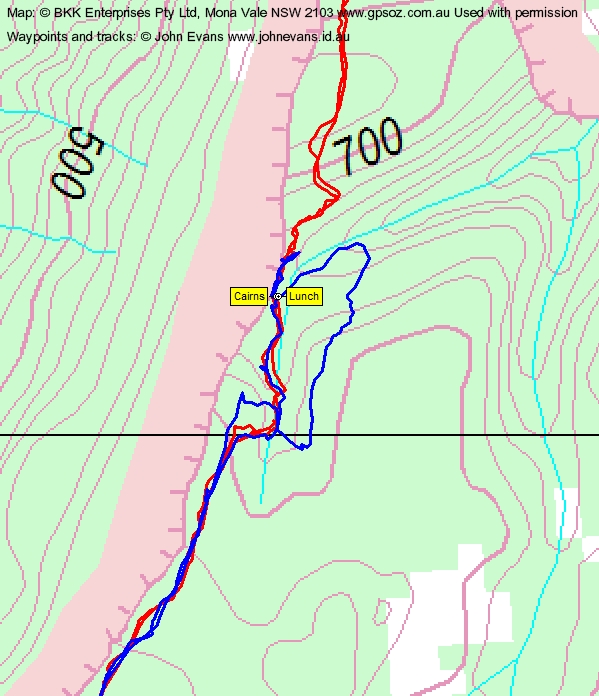
The red track is from 31 Aug 10, and the blue track (including where I went further north for a pee) is from today. So it looks very likely that the cliff side route and not the slippery scramble is the way forward. I apologise unreservedly to the walk leader for my contribution to the decision to turn back. And this would explain our lack of memory of such an exposed scramble here. It’s important to document this, as others reading this post might be put off. Don’t be.