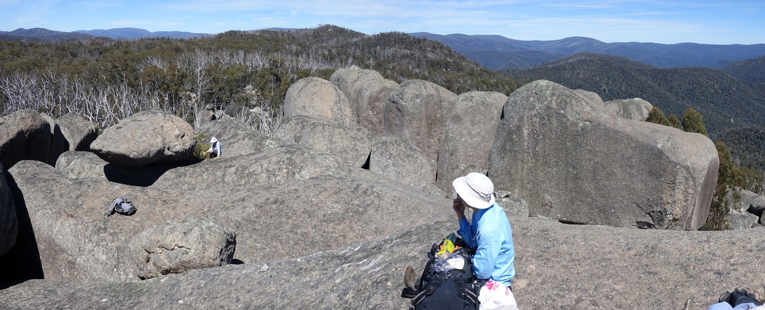
View west from the top of Billy Billy Rocks
Tuesday 21 November: Billy Billy Rocks from the East – M/R. Follow a well taped and cairned footpad starting near a sharp bend in Corin Road, just south of where Billy Billy Creek crosses the road. I know the pad climbs the spur for at least 1.5km and an October Wednesday Walk followed the entire route. Continue west on the pad to cross Billy Billy Creek and access the Billy Billy Rocks area. The objectives are two geocaches, GC1A7XY William Totally Rocks! (on the east end of the rocks) and GC1PVHC Granite Cascade (100m below the top rocks on the north face). Climb to the top for grand views over TNR and to the Tidbinbilla Range. Around 7km and 500m climb. Map: Corin Dam. Leader: John Evans 0417 436 877 john@johnevans.id.au . Limit: 8 walkers who don’t mind rock scrambling. Transport: ∼$7.
Further Information
Previous trips here (all from Smokers Gap) on 12 Jan 08, 26 Feb 11, 26 Jul 14 and 14 May 16,
Summary
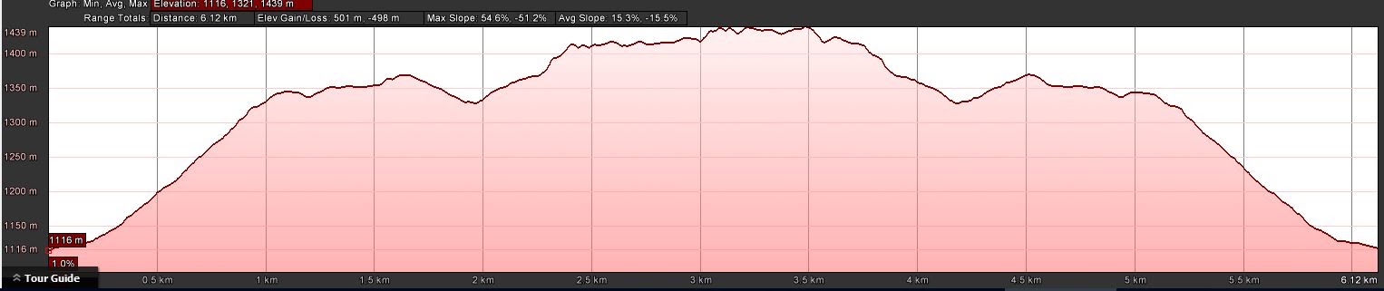
Distance: 6.2km | Climb: 500m | Time: 8.10am – 12.40pm (4hrs 30mins), including 60 mins of breaks | Grading: S/M-R,ptX; M(10)
Photographs
Photographs are available, where you can start a large sized slideshow.
Videos
Waypoint and Track Files
Download the .gpx file. (Right click, Save Link As…, Save – if you want to use it.)
To use in Google Earth, do File, Open… and select Gps or All files as the File Type.
Track Notes
You would hardly think that this was a Tuesday Walk – 5 hours door to door from my old folks home. Some walkers may not have felt adequately exercised. Anyway, a chance to do the full footpad in from the east, coming off Corin Road. We’d used some of this footpad on 24 Aug 17, and I was interested to see where it went. A Wednesday Walk in September confirmed that it went to Billy Billy Rocks.
It was a lovely day and it is indeed a lovely footpad. Knowing that it was heavily cairned and taped, I’d prepared a little leaders briefing about destroying said objects. But, hearing no crashes or tears behind me, kept it to myself. We all draw the line differently to marking routes. There is a bit of a puff up the first long hill (check out the profile). But it is a great route. I only lost it once going in and once coming out. Easy walking gives one a chance to admire the close plants and distant hills.
The tapes and cairns took us to M23, where we found a great outlook for morning tea.
Following the break, I spent some time looking for geocache GC1A7XY William Totally Rocks!. A couple of passages and crawls involved through the boulders. I was right on the 0m GZ, but no sign of it (take the spoiler pics next time, you ding-bat). With 8 others in the party, I made the call to move on. We’ll have to come back for pure caching, Marmaduke Rothschild.
We then headed SW across the crest of the Billy Billy Rocks area to pick up the usual approach route. Jenny had a GR with her that was right on the money for Cairn 1. But I don’t know my way around the boulders, so what followed was either an inelegant approach or a chance to try new routes. Many ways to skin a cat. We reached the top boulders at 10.30am. Lovely on top – sun, no breeze, great views. We soaked it in for 20 minutes.
We came down a much more straightforward route and retraced our steps. I abandoned caching. Lunch on the way home.
Track Maps
Track
Marked with Tnn and Cnn for cairns and tapes (recorded on 24 Aug 17). Marked with Mnn for markers (recorded today).


Party
9 walkers – Melinda B, Peter C, Linda G, Meredith H, Ian H, Jenny H, Lloyd O’K, Phillip S, me.