Pago Weir

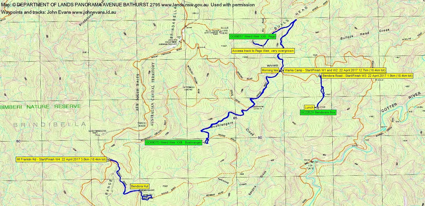
Saturday 22 April: Warking in the Brindabellas – L/E-M. From a base at the Warks Camp area on Bendora Road, three short warks to nearby features. First, north along Warks Rd, then south-west up Old Mill Rd to join Pago Break. A short but scrubby entry to Pago weir. Around 6km return. Next south-west along Warks Rd to Bushranger weir with another short, but scrubby climb up to the weir. Around 7km return. Then drive 1km down Bendora Rd and a 2km return bush-bash to Bendora trig. Finally, a drive to Bendora Dam and a very short walk. Around 17km and 400m climb in total. There is a geocache at each destination. Map: Tidbinbilla. Leader: John Evans 0417 436 877 john@johnevans.id.au. Transport: ∼$15 per person.
Further Information
With thanks to John Burns, who built these weirs. A list of Brindabella weirs.
Summary
Distance: 18.4km | Climb: 400m | Time: 8.30am – 2.50pm (6hrs 50mins), including 30 mins of breaks and 20mins driving | Grading: L/E-M; M(10)
Photographs
Photographs are available, where you can start a large sized slideshow.
Videos
Waypoint and Track Files
Download the .gpx file. (Right click, Save Link As…, Save – if you want to use it.)
To use in Google Earth, do File, Open… and select Gps or All file as the File Type.
Track Notes
As I motored north to the meet point through driving rain, I thought “I should cancel this, but then I’d be known as a wimp”. The Brindies to the west of Canberra where invisible, covered in grey. No better looking from Weston, although the rain had lessened.
We drove via the Cotter and up Brindabella Road and onto the Mt Franklin Road at Piccadilly Circus. At Bulls Head we turned left down the Bendora Road and parked at Warks Camp. The showers had stopped.
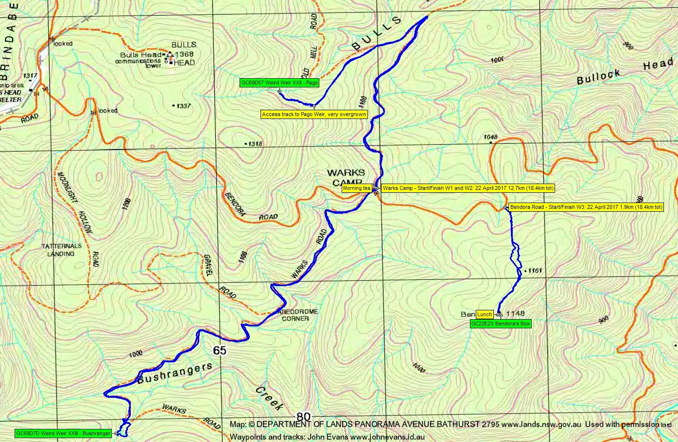
We first wandered along Warks Road to the SW for 3.3km to the point where a branch of Bushrangers Creek crosses the road. A couple of hundred metres up the creek is Bushranger weir. Most of us struggled up through the wet bush to the weir and we geocachers nabbed GC69D7D Weird Weir XXIII – Bushranger. After a look about we returned down the creek. Lovely damp mosses and greenery towards the bottom. A walk back to the cars and morning tea.
Next we headed north along Warks Road and sharp left up Old Mill Road. Then onto Pago Break. Around 500m up the Break, near the bottom of the steep pinch, we went bush along the old access ‘road’. It’s strewn with logs at the beginning and is fast being reclaimed by the bush. But you can see the benching in places. In to Pago weir to bag GC69D57 Weird Weir XXII – Pago. Reversed out and back to the cars, a 5.7km round trip.
Then we drove down the Bendora Road a bit to a spot on a bend which gives access to Bendora trig. The route is very overgrown, but the going is quite mild. On our GPSr maps it’s marked as Dwyers Road, but if you look on the 1st edition Tidbinbilla 1:25000 map, it is marked as a power line clearance, the line going to Bendora Dam. We walked up to Bendora trig, logged geocache GC22E2X Bendora’s Box, then had lunch. Returned to the cars, a 1.9km round trip.
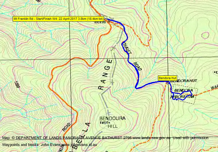
We didn’t go on down to Bendora Dam and the last caches, but drove back up to the Mt Franklin Road and south to the Bendora Arboretum car park. I particularly wanted to see if the European Larch were in their autumn golden glory. A 3.8km round trip to the arboretum and a wander round the newly marked walk through the trees. Lots of red toadstools. I reckon we were about two week’s early for the Larch. They have started to turn golden, but have more to go.
Thanks very much to old and new walking and geocaching friends. Just goes to show that one should always carp the diem and have at least one person in the party in their raincoat to keep the rain away.
Track Maps
Party
7 walkers – Cynthia C, Roger E, Martin E, Chris F, Jenni S, Phillip S, me.