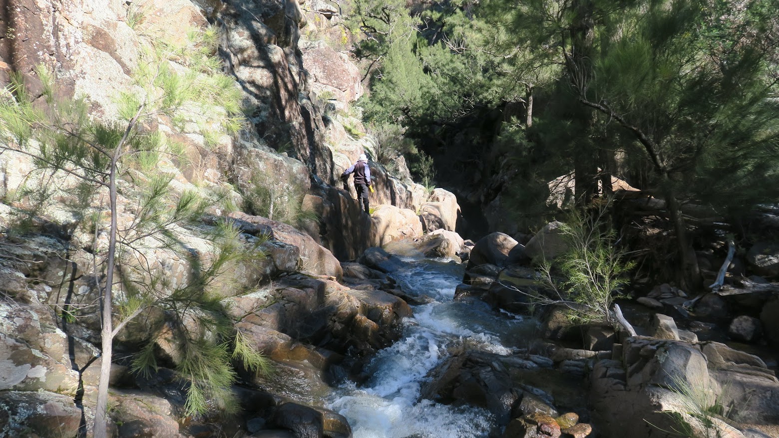
Linda susses out the way down a canyon on Swamp Creek
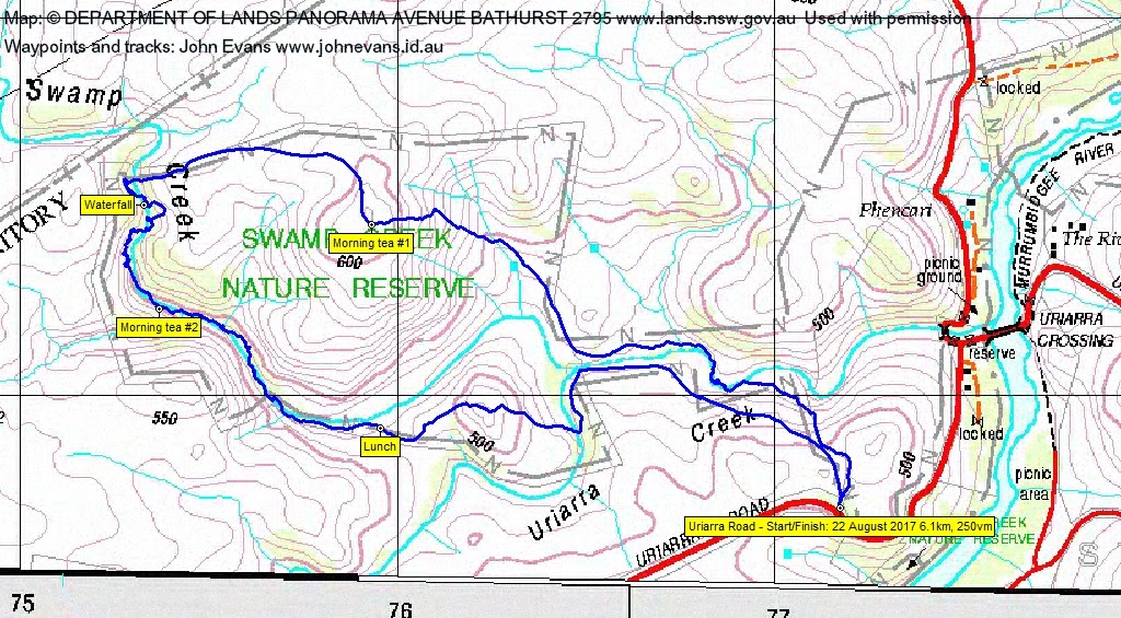
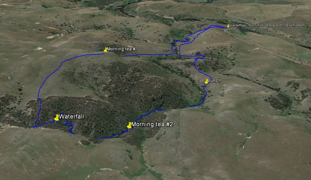
Tuesday 22 August: Swamp Creek exploratory – S/R/ part X. Swamp Creek Nature Reserve, which joins the Murrumbidgee near Uriarra Crossing, appears from Google Earth to have two dry waterfalls above large pools. We will try to reach these. In the first 2 km of the walk, our route will cross grassy hills and then follow the creek in its gentle mode. We’ll then climb a hill with good views and descend into the upper section of the creek, where steep slopes guard the waterfalls. Rock scrambling likely, some creek-wading may be necessary. There will be some blackberries and other scrub. 6 km total, some of it at 1 km per hour. 60 metres down, 150 metres up and down, 60 m back up. An 8.30 am start. Map: Umburra. Leader: Linda G. Transport: drive yourself but let me know if you need a lift of can offer a lift to any walkers who live near you.
Further Information
The last time we were in Swamp Creek NR was 2 Aug 15.
Summary
Distance: 6.1km | Climb: 250m | Time: 8.35am – 1.25pm (4hrs 50mins), including 60 mins of breaks | Grading: S/R; M(9++)
Photographs
Photographs are available, where you can start a large sized slideshow.
Waypoint and Track Files
Download the .gpx file. (Right click, Save Link As…, Save – if you want to use it.)
To use in Google Earth, do File, Open… and select Gps or All files as the File Type.
Track Notes
Yet again, hats off to Linda for another interesting and hair raising (and adrenaline raising) walk. Short today, but oh so sweet!
Ming continues to enjoy new experiences with us too – today was fence crossing, log walking and snake spotting. And spotting a wombat out for a day time walk.
A fabulous walk in the Swamp Creek Nature Reserve. We had a lot more elegant start point today, off the Uriarra Road and free of blackberries. But not for long, as we plunged down to Swamp Creek and into the guardian blackberries.
We got our eye in with some walking up the creek for a while, then bent up to the NW to climb the 620m knoll in the middle of the NR for morning tea #1. Eagles soared. We left the top to the north, then west down to rejoin Swamp Creek around 130m shy of the ACT border.
This was the part of the creek that Linda had scouted via Google Earth. It was, indeed, full of cascades, blackberries, requiring multiple creek crossings, negotiating blackberries, pools, blackberries (thanks for bringing the snippers, Philip), a waterfall, blackberries …. Much fun and a few adrenaline rushes on my part. Particularly at the little canyon that Linda, thankfully, went forward to suss out. We stopped for morning tea #2 for me to calm down – anyone else?
More of the same after the break, crossing and re-crossing Swamp Creek. At one point it was via an under-water log. I gave up after a while and, to preserve my life, crossed via the creek and wet feet. But at last the gradient lessened, my heart rate dropped and we were out lolling around for lunch. The talk, as I dozed, was of walking in South America – how fabulous.
A climb to a 520+m knoll through open going after lunch. Then a plunge down to cross Uriarra Creek, a walk beside Swamp Creek over (thankfully) open ground, then up to the cars. Many sheepish eyes watching us.
What a great walk. If you weren’t on it, either ‘suffer in your jocks’ (my 2nd favourite line from the Australian classic film The Castle) or do it yourself!
Huge thanks Linda. And a great party.
Track Map

Party
8 walkers – Peter, C, Philip and Jan G, Linda G (leader), Meredith H, Kim H, Ming L, me.