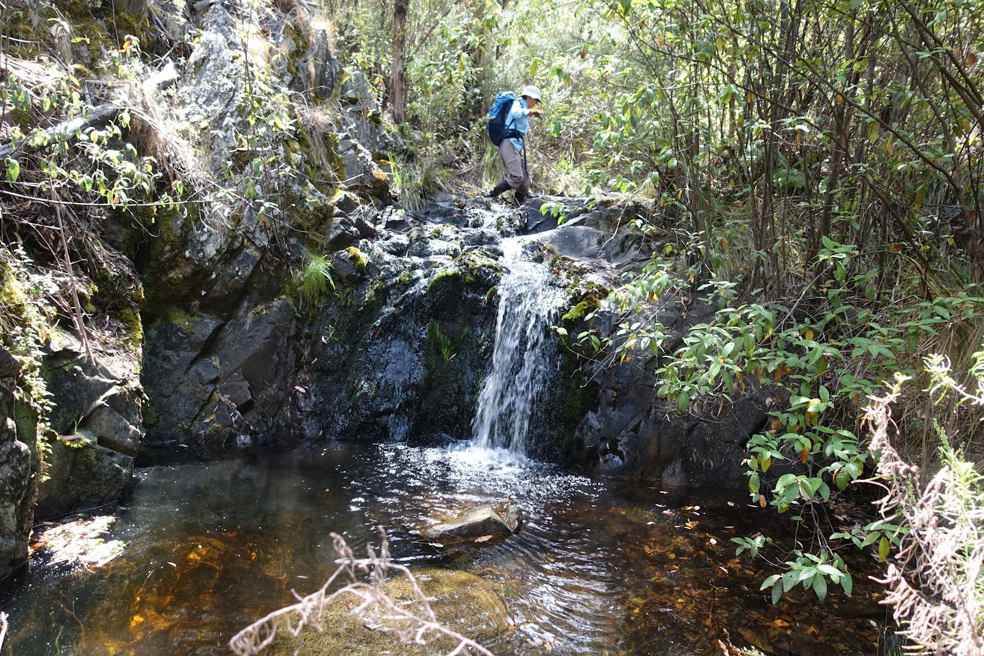
Cascade and pool on White Sands Creek
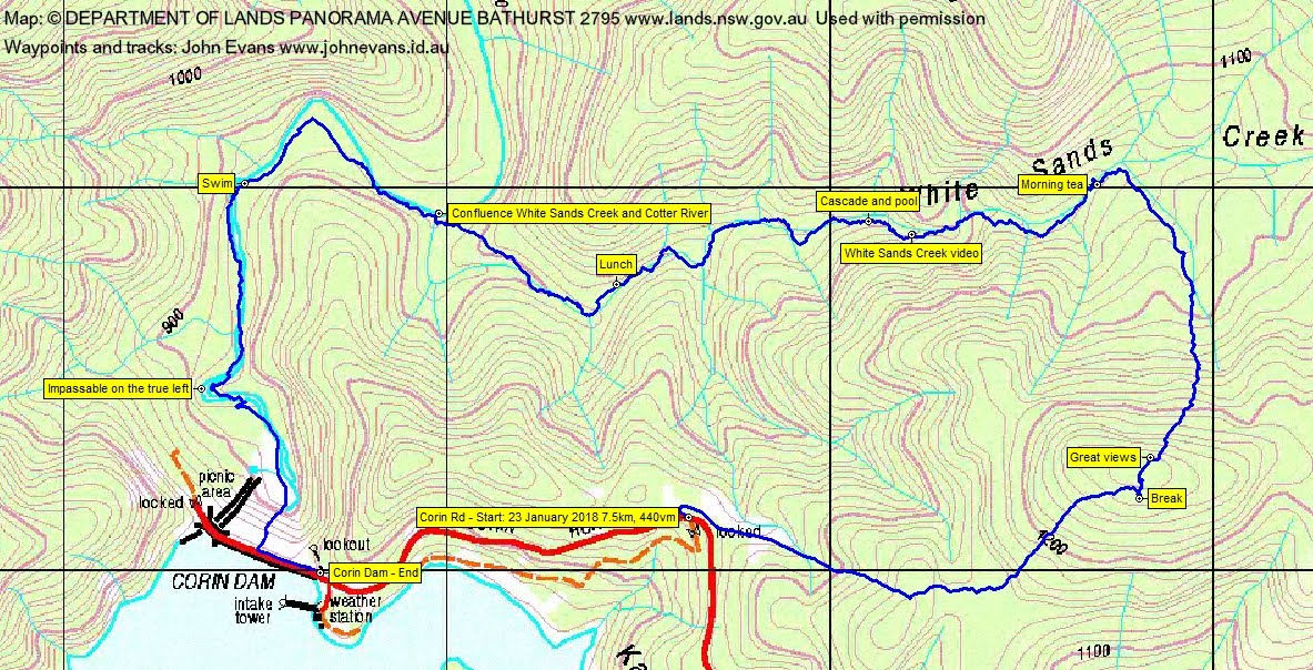
Tuesday 23 January: White Sands Creek exploratory – M/R,XW. A circuit from the Corin Dam Road, climbing to granite outcrops for views and then following White Sands Creek down to its junction with the Cotter. Back up a ridge. This area has lots of scrub, but on a recce I found that some of it could be avoided by wading the shallow parts of the creek – so this is a good walk for hot weather. Map: Corin Dam. Leader: Linda G.
Further Information
Crossed White Sands Creek on a trip to Greens Peak (SH1409) on 1 Oct 16. Walked up the Cotter River in this area on 28 Jan 14.
Summary
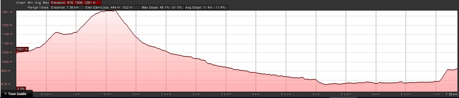
Distance: 7.5km | Climb: 440m | Time: 7.55am – 2.50pm (6hrs 55mins), including 80 mins of breaks | Grading: M/R; M(10+)
Photographs
Photographs are available, where you can start a large sized slideshow.
Videos
Waypoint and Track Files
Download the .gpx file. (Right click, Save Link As…, Save – if you want to use it.)
To use in Google Earth, do File, Open… and select Gps or All files as the File Type.
Track Notes
Our good walk leader initially beat this up as an unimaginative trip (although great for a 38ºC day). It turned out to be far from it, an excellent walk!
Walking by 7.55am from the side of Corin Rd around 1.25km before Corin Dam. I’d walked from here before, the last time to visit ‘Corin trig’ on 19 Nov 17. But this time we turned right from the old road entrance and walked steeply up the power line track for 700m before turning into the bush. A fraction down, then flat, then a 120vm climb to some reasonable granite for a drink break. Not too hot yet and, in fact, 4 or 5 sprinkles.
Traversing the knoll, which is the SW end of High Range, from south to north, we came upon awesome views to the north across White Sands Creek and up to Greens Peak (SH1409).
Next a 230vm descent, steep at first, over 1km to hit White Sands Creek. That took 45mins. One wag wanted white sands, ukuleles and swaying palms, but the best (sand-wise) we got was yellow-grey.
What followed was a delightful trip down the creek. In it, on either side of it, ducking and weaving under branches, came upon one nice little cascade and pool. Great to have wet, cool feet and legs as the day heated up. In all (including 45mins of morning tea and lunch), a 2.6km journey taking 3hrs 10mins. Check out the photos and videos.
The Cotter River was flowing strongly. Lovely to stand in the water and wet down.
We then walked up the river to the dam wall, 1.9km taking 1hr 25mins (including a 20min swim). The swim was just the thing to prepare me for the 2 river crossings. I feel like I’ve come of age (about one year old), as I’ve never crossed a river in this manner before. Many thanks to Linda for the detailed instruction.
Some of us scaled the dam wall. To finish it off, the cars were brought down to the town side of the dam, where the rest of us were sitting in the shade at the lookout steps.
Yet again, another wonderful walk put on by Linda.
Track Maps
Party
6 walkers – Melinda B, Peter C, Linda G (leader), Meredith H, Ian W, me.