Who’s out there? Dan an(d) Bill a(re)!
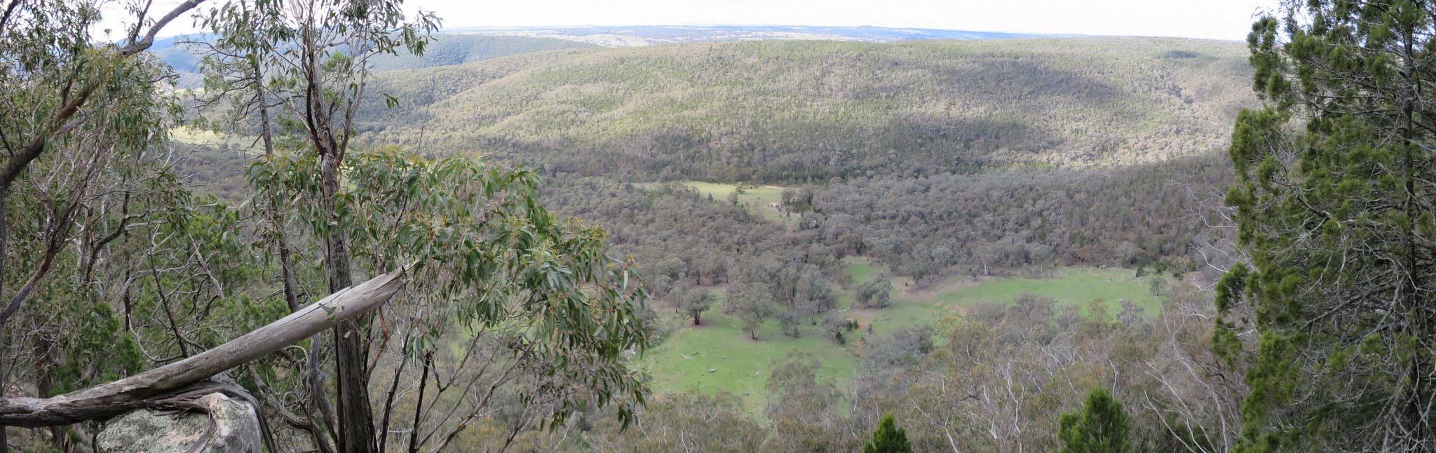
View down to the cleared valley below and across to the Illunie Range
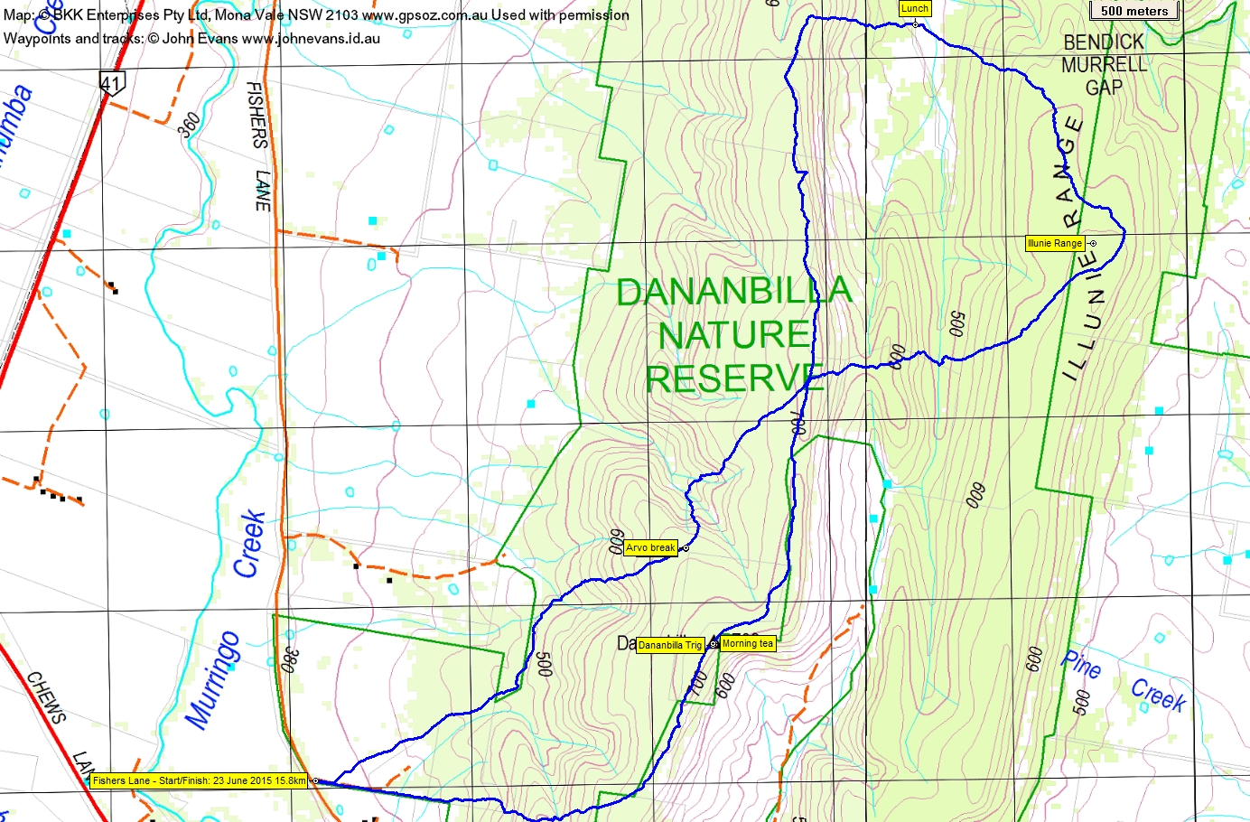
Tuesday 23 June: Dananbilla Nature Reserve L/R,X. The reserve is approximately 35 square km in size, covered in native forests and woodlands, and is located 20 km northeast of Young. This is an off-track exploratory walk, in steep country. This is a new area for the leader. There is a 2 hour 15 minute drive each way. Minimum distance: 16 km with 900 metres of ascent. Maps: Bendick Murrell, Koorawatha 1:50,000. Leader: Ian W. Transport: 324 km return. Limit: 8.
4 of us drove via the Barton Highway, Hume Highway, Lachlan Valley Way through Boorowa, Murringo Gap Rd through Murringo, and finally Fishers Lane to park at the entrance to the Nature Reserve.
Further Information
The Dananbilla, Koorawatha, Illunie and Gungewalla Nature Reserves plan of management can be downloaded from here.
Summary
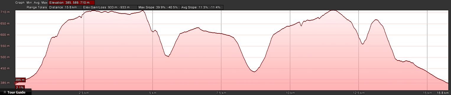
Distance: 15.8km | Climb: 930m | Time: 8.20am-3.40pm (7hrs 10mins), including 1 hr of breaks | Grading: L/R; H(13)
Track Map
Track
Profile
Photographs
Photographs are available, where you can start a large sized slideshow.
Waypoint and Track Files
Download the .gpx file here. (Right click, Save Link As…, Save – if you want to use it.)
Download the .kml file here.
Track Notes
The day began at 5am – time to get up. A check of the weather forecast for Young revealed that the weather was holding, with showers from the evening. Breakfast included boiling a full jug of hot water to fill the new 1 litre thermos. Picked up from home at 6.10am and driven to Belconnen, where we all piled into one vehicle for the drive. A lot of people live in Yass and drive to work in Canberra, to be sure. A pleasant trip, including lovely colours in the dawn sky. The countryside around Murringo is lush and green. The trip was a little quicker than expected – arrived at the entrance to Dananbilla Nature Reserve around 8.15am. So around a 2 hour drive from Weston Creek.
Quite cool as we set off along a short flat bit. But Ian has developed a habit of giving us a substantial climb at the beginning of the day and today was no exception. In fact, extra steep today because we were working from a 1:50,000 scale map with 20m contours. In your mind you forget to add the extra 10m contour between map-marked contours – until you start to climb! We were very quickly into the predominant trees of the day, Black Cypress Pine (Callitris endlicheri). The leg from the start to Dananbilla trig was 2.9km in 1hr 5mins and morning tea there was most welcome. The trig’s stone-worked base was collapsed on one side, but well formed on the other.
From here we headed north along a lovely reasonable open ridge, then steeply down across a little saddle, up, down, then steeply up onto the Illunie Range. You can see from the track profile that it was a rather up and down day.
The Nature Reserve is surrounded by rich farmland and there are fingers of cleared land between the two ridges we walked. The northern finger is now (since 2009 I think the Ranger said) within the NR. We descended to it, passing fine examples of another prominent tree in the area, Red Ironbark (Eucalyptus sideroxylon). Across the dry creek bed we passed by an old building structure and found lunch nearby. Lovely in the sun. From morning tea to lunch was 5.9km in 2hrs 10mins, with some substantial ups and downs.
After lunch we climbed back up onto our morning’s first ridge. From lunch we’d seen some interesting looking small cliffs, so once on the crest we walked the west side and took in the views at various spots. Quite steep down to the more open valley floor (remember the contour interval on the maps segment is 20m). From lunch to where we touched our morning’s track was 2.9km in 1hr 55mins.
Here we bent away to the SW and headed back to the car. A great little drainage line feature amused us (down then up) on the way. This final leg 4.1km in 1hr 45mins, including our 10min arvo break.
Back at the entrance gate a Ranger drove down behind us and stopped for a chat. Very nice lady with plenty of information, including a suggestion to visit the woodland section of the NR that hangs out to the east of the main north-south area. This is relatively recently acquired grazing land. Lots of wildflowers in November. She pointed out another public access point in this part and gave us a map. Although based in Queanbeyan, she was up tree planting with a group of volunteers from the National Parks Association – ACT.
Huge thanks, Ian. Another new area and a very nice day. I feel well exercised!
Party
4 walkers – Eric G, Ian H, Ian W (leader), me.
Next Tuesday Walk
Tuesday 30 June: Budawang National Park, Currockbilly Mountain – M/M,ptX. We will follow the track up to Currockbilly and then head north through the heath that was (hopefully) burnt out in the 2013 fires before tuning west back down to a fire trail and thence back to the cars. Map: Brooman. Leader: Ian H. Transport: $88 per car. Limit: 8.