Exped bed, where have you been all my life?
The Mt Scabby top

Mt Gudgenby at the back of knoll 3, knoll 1 and knoll 2

Saturday-Sunday 27–28 June: Mt Scabby – M/R. Day 1: Old Boboyan Road car park, saddle south side of Gudgenby, Sams Creek, Scabby ridge, dry camp. Day 2: Mt Scabby, Sams Creek and return. Maps: Yaouk, Rendezvous Creek. Leaders: Jenny & Rob H. Transport: $40 per vehicle.
8 of us drove in 2 vehicles to the Yankee Hat car park.
Further Information
If the opportunity arises, geocaches GC50N5B Marking our territory 8, GC21C1A Source of the Cotter.
Summary
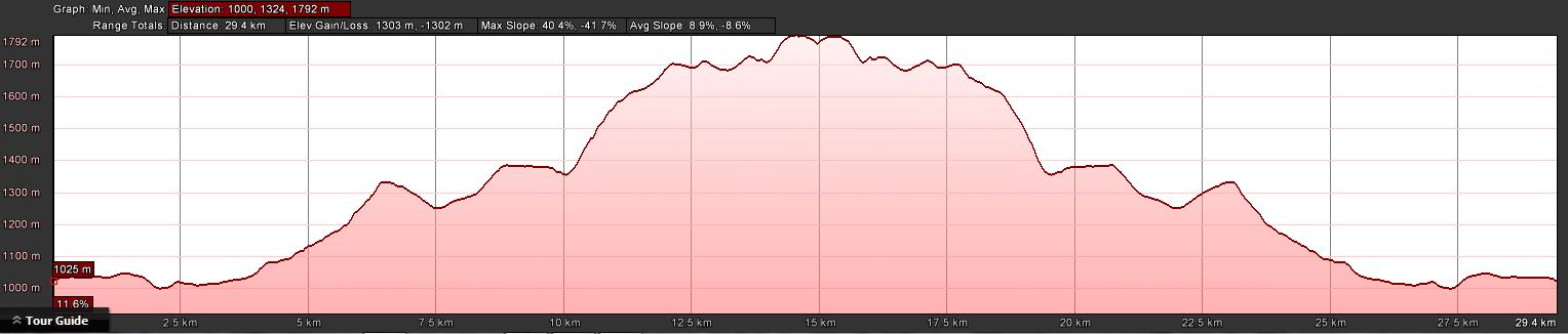
Distance: 30.8km | Climb: 1300m | Time: 2 days | Grading: L/R; H(12)
Track Maps
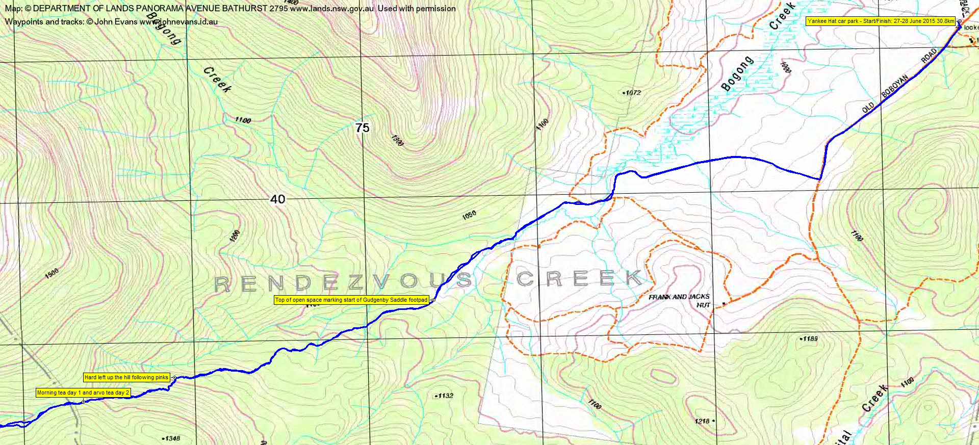
Track overview

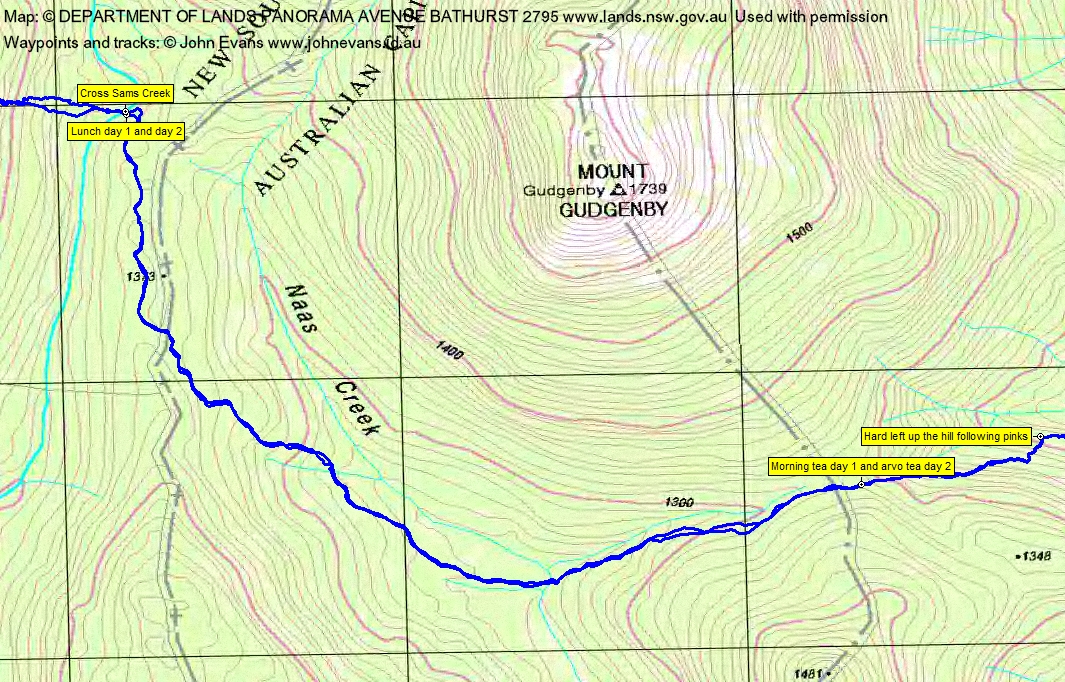
Track 1
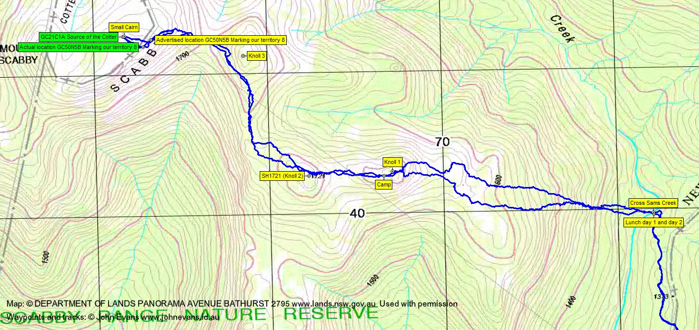
Track 2
Track 3
Profile
Photographs
Photographs are available, where you can start a large sized slide show.
Video
Waypoint and Track Files
Download the .gpx file here. (Right click, Save Link As…, Save – if you want to use it.)
Download the .kml file here.
Track Notes
The last time I walked this route was down from Scabby on 8-9 Jul 06 and it was quite ok. I’m a little older and the vegetation a lot thicker now. Even our trusty leader agreed that his memory of the route was similarly upgraded.
A bit frosty over the grasslands up into the mouth of Middle Creek as we got ready, but the sky was bright blue and the weather forecast was for a clear but cold weekend. A moderate pace and we made the south-east Gudgenby saddle for morning tea at 10.15am, 6.8km in 2hrs 10mins.
Our next leg took us down to cross Naas Creek and then to pick up Sams Creek Fire Trail and follow it to cross Sams Creek. 3.7km in 1hr 40mins. Here we had lunch and picked up water for our dry camp.
Away at 1pm to begin the climb up towards the Scabby top. Packs a bit heavier, with each of us carrying at least 4 litres of water. A slow climb, steep in places and certainly more vegetation than Rob or I remembered. Some nice views opened up across to Mt Gudgenby and, as we climbed further, south-east down the Naas Creek valley and Sentry Box, and south to Yaouk Peak. We reached knoll 1 at 3.50pm. Rob’s proposed camp site was still over 1km away and over knoll 2, so he made a wise choice for us to stop at the first likely camp site for the 8 of us, just over the west side of knoll 1. We’d covered 2.3km in 3hrs, climbing some 400 vertical metres.
We set up our tents and, for the first time, I blew up my new Exped synmat hyperlite sleeping mat. Not easy with the funny shaped valve. Then the usual drill of tea around the fire and a chat. As usual, I was the first to pike, retreating to my bed for a couple of hours of music. But what delight! Such comfort. To top it off, there was phone reception, so I rang my dear wife from my bed and told her I was so comfortable that I would be doing a lot more overnight trips 😆 . A wonderful night’s sleep and quite balmy too – no frozen water (and a good thing for those who had only brought flies!).
Up at 6am because our stop shorter than planned left us with more to do. We left our tents up and took day packs and were ready to go by 7am.
Again, thanks to Rob. He knows that it’s all in the objective for me and those 2 geocaches were calling, so he allowed Jacqui and Mac and me to scarper ahead. We made quick time and covered the 2.2km to the advertised location of GC50N5B Marking our territory 8 in 1hr 15mins. We looked back and saw the other party on the top of knoll 3 (we’d sidled round the south-west side of it). Thanks to the FTF party for this cache, I knew that the real location was another 44m away. We broke out onto the open slabs and soon had the cache in hand beside one of the toes of the rock foot. We then went west across slabs to a small cliff-ette. Jacqui climbed down and retrieved the ammo box of GC21C1A Source of the Cotter for me.
Objectives achieved, we admired the wonderful views. Check out the video and photos! But there was not time to loop round to the source of the Cotter River and to the map-marked Mt Scabby. (Some discussion on this one – the map-marked location is less than 1800m high, but there is an 1800m contour on the eastern side of the top.)
We returned to the eastern edge of the Range and the other party popped their heads up over a slab. So we all went back to the lookout area to enjoy the views.
It was all over bar the shouting for me (although still a long walk home). We retraced our steps from the lookout near the small cairn to camp, taking 1hr 30mins for the 2.4km. Rob certainly took a better line NW of knoll 2 – I’d slid down a bit into the scrub before Mac reminded me to get back up on the crest; Rob’s return leg followed the open crest of the gentle spur.
We packed up and regrouped up on knoll 1. From here, 2km in 2hrs to descend to Sams Creek. Our track down was a bit north of our track up. Lunch sitting where we did on the trip in, beside Sams Creek in the sun.
We left at 1.40pm and covered the 10.3km back to the cars in 3hrs 30mins.
Not the easiest way to get to Scabby, but it certainly was a fabulous trip. Thanks so much, Rob and Jen, for taking us there!
Party
8 walkers – Rob and Jenny H (leaders), Ron K, Mac K, Meg McK, Jacqui R, Stephen T, me.
Next Saturday Walk
Saturday 4 July: Sentry Box Rock from Old Boboyan Rd (South) – L/M-R. Starting from the Old Boboyan Rd (South) car park, walk the management trail to Lutons Crutching Shed. Continue up the Sams Creek Fire Trail and Maurice Luton Fire Trail to the border. A further 3km off-track and 350m climb through unburnt forest and easy granite slabs gets us to Sentry Box Rock and geocache GC1GP3Y Lonely Sentinel. Return the same way, calling in on Sean’s party for tea at Lutons. A long day, including night time walking. Around 35km and 500m climb, all but 6km on fire trails. Map: Yaouk. Leader: John Evans 0417 436 877 john@johnevans.id.au . Transport: ∼$15 per person.
Sean Sunley
29 June , 2015 9:22 amLooks like Julie and I missed a good trip. Next time. We also have Expeds, very comfy. I have a little pump for inflating.
Johnny Boy
29 June , 2015 9:46 amIt was a great trip Sean. 25 breaths to blow it up! Mac showed me his little pump, no doubt like yours. Ordering one now. See you next Saturday evening!
Guy Morrison
11 May , 2016 10:04 amWe did a similar 3 day walk to this in the mid 70s: Up to the pass south of Mt Gudgenby, down into the valley, up what must have been the Sam’s Creek firetrail. I think we went further up Sams creek than this walk did and we then ascended directly west to the summit of Scabby. I remember it was a less arduous walk than many of the walks we did in the ACT ranges and arriving at the summit plateau was rather surreal and beautiful. Then we ate things such as vesta meals and instant puddings and (definitely not recommended) smoked cigarettes.