Saturday-Sunday 28-29 October: Coronet Peak – M/M-R. This is a re-enactment of the first ever overnight trip I led, on 5-6 Nov 05. Can I make it 12 years later? Walk in the Australian Alps Walking Track from the Orroral Valley. Camp at Pond Creek. Ascend off-track with a short and easy scramble to Coronet Peak for uninterrupted 360° views. 2 or 3 geocaches. Return the same way. Around 30km and 1280m climb over 2 days. Maps: Rendezvous Creek and Corin Dam. Leader: John Evans 0417 436 877 john@johnevans.id.au . Limit: 8. Transport: ∼$12 per person.
Further Information
We went up Split Rock, too. Last trips to Coronet Peak for me were 8 Apr 17, 25 Jul 15, 21 Oct 14, 19 Nov 13, 22 Feb 11, 11 Aug 09, 30 Oct 07, 5-6 Nov 05.
Summary
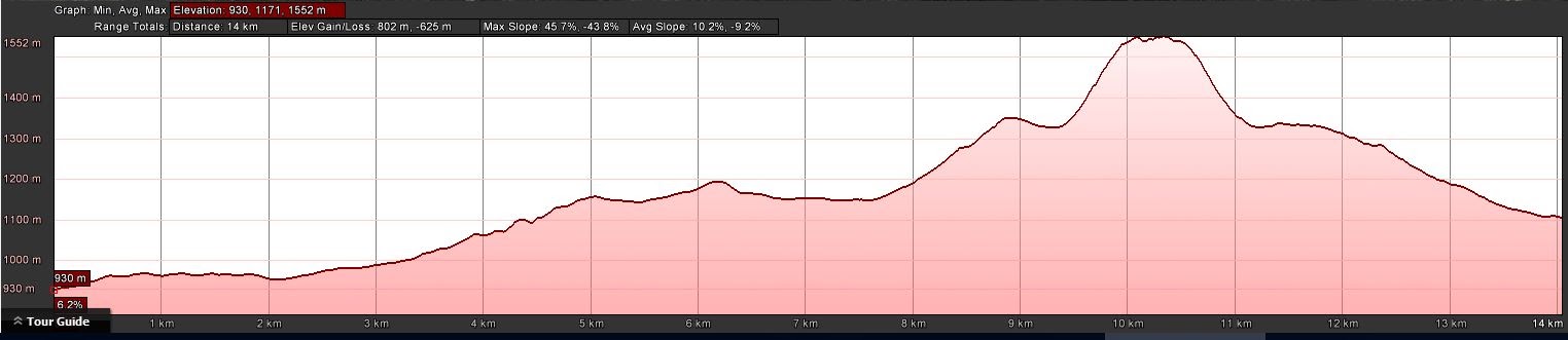
Day 1: Distance: 14.2km | Climb: 800m | Time: 8.40am – 2.55pm (6hrs 15mins), including 40 mins of breaks | Grading: L/E,R; H(12)
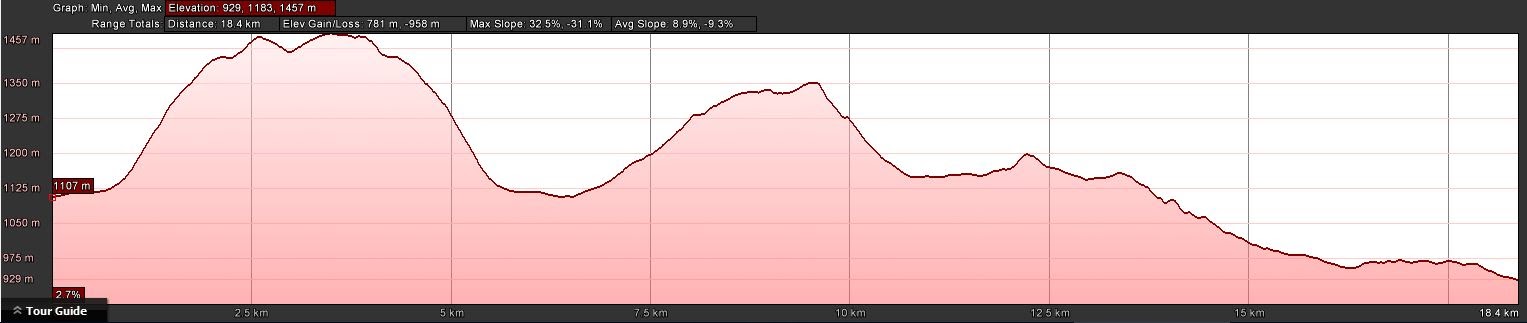
Day 2: Distance: 18.7km | Climb: 750m | Time: 8.00am – 4.55pm (8hrs 55mins), including 1 hr 15 mins of breaks | Grading: L/E,R; H(13)
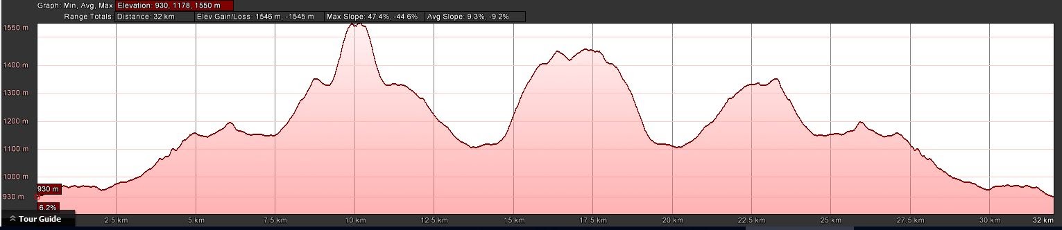
Total: Distance: 32.9km | Climb: 1550m | Time: 2 days | Grading: L/E,R; H(13)
Photographs
Photographs are available, where you can start a large sized slideshow.
Videos
Waypoint and Track Files
Download the .gpx file. (Right click, Save Link As…, Save – if you want to use it.)
To use in Google Earth, do File, Open… and select Gps or All files as the File Type.
Track Notes
Saturday
A great crew of newish and older hands assembled. We were 8 at the start, with Neil riding and walking in (in 2 hours from Orroral Tracking Station to Pond Creek!) on Sunday morning. No wonder he was a mite sweaty when we met!
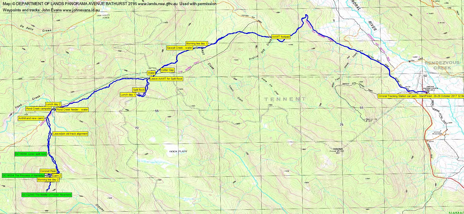
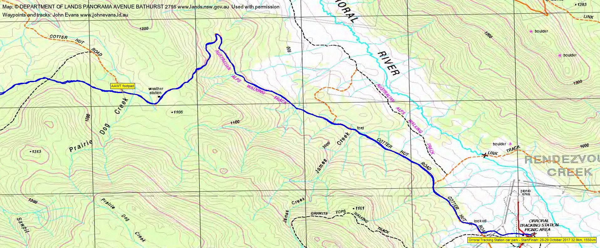
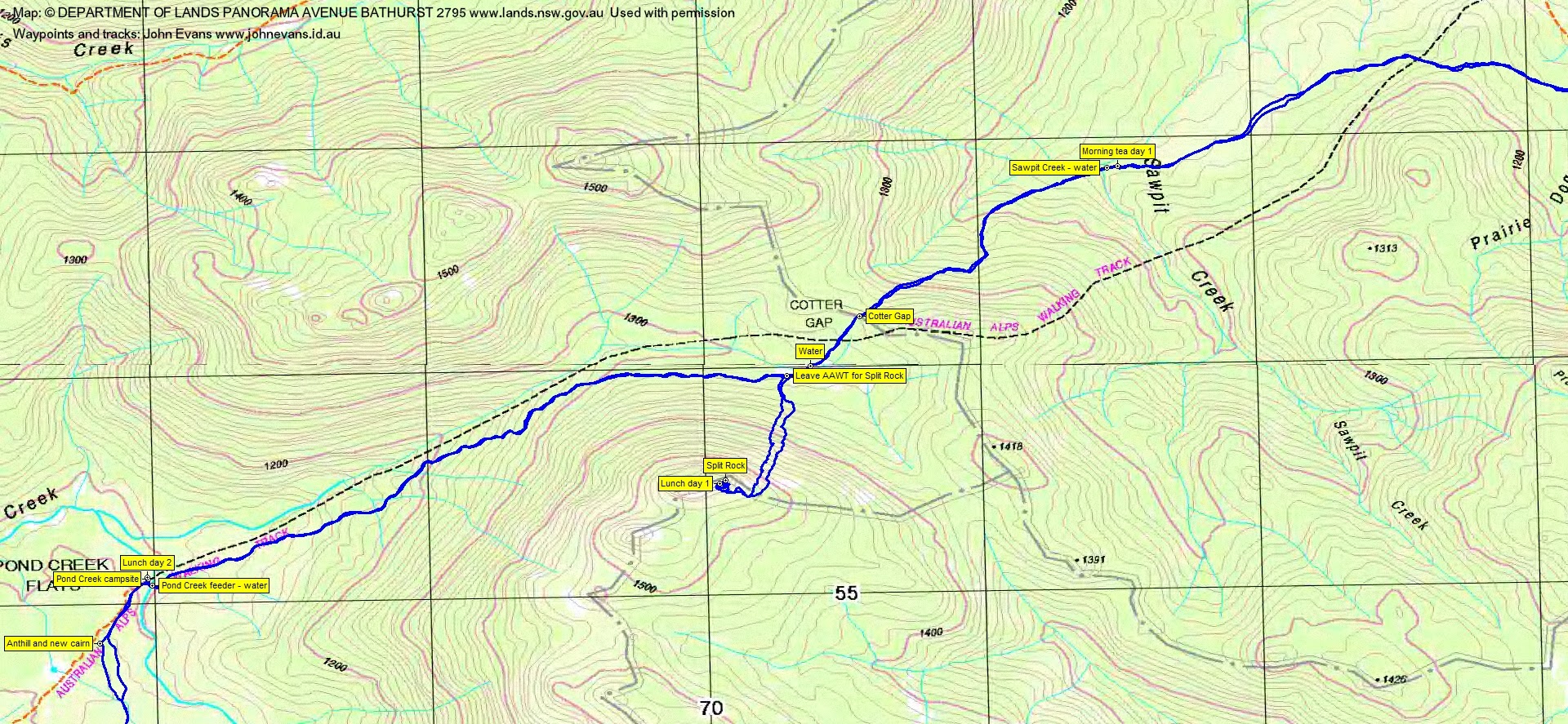
An overcast day, pretty alright for walking. We endured the Cotter Hut Road to the AAWT footpad junction, 5.7km in 1hr 30mins. Now softer on the feet, we walked 2km in 30mins to Morning Tea at Sawpit Creek. You may wonder, good reader, why I record all these distances and times, on this trip in and out with overnight bags. When I am older and more decrepit, I will sit and read these posts and dream of bygone days. Methinks that will be sooner than later. Then the grind up to Cotter Gap and a little over to cross the top of Pond Creek, drop our big bags and pop some goodies in day packs for lunch up on Split Rock. This leg 1.8km in 1hr.
A direct ascent of Split Rock, but no route can escape the band of regrowth guarding the back entrance to the feature. We had a good explore through the split, popped out the far end, saw Robyn searching for the geocache up there, then backed out to join her beside Split Rock for lunch. 2hrs 15mins for the return trip, including exploring and 25mins lunch.
Heavier loads on our backs again, but at least it was downhill to our camp site, just over the Pond Creek feeder and right turn onto the narrow footpad that leads to the elongated camp site. 2.9km in 50mins. We arrived at 2.55pm. I had been warned – the place was seething with ants, which didn’t disappear until sundown.
The usual drill – set up tents, collect water, no fire as we were in the Bimberi Wilderness area. A lazy afternoon, cloud threatening showers. My new chair (thank you again Mike) kept my butt off the ground and away from the ants. I think we ate at pensioner time of 6pm and drifted off to bed just after 7pm. A couple of gentle lots of rain during the night. I disgraced myself by snoring (but reportedly only gently).
Sunday
Up around 6.45am. Patches of sun, but soon the clouds rolled over and by the time Neil arrived (spot on the agreed 8am), the clouds were down over Cotter Rocks. Now with 2 trig baggers and 2 geocachers to satisfy, thoughts whirled through my mind as to how everyone could be satisfied.
We set of with day packs along the AAWT to the anthill and little cairn, marking the start of an overgrown old vehicle track which goes up and over to Little Creamy Flats (you can see it on the ADG66 edition Rendezvous Creek 1:25000 map). Thankfully, the bush was not wet. 1.5km in 45mins into the morning, we arrived at geocache GC1KD5K Junior split rock.
Coronet Peak was clouded, so we agreed on the call to head for the geocache GC1Q2W0 The Middle of Frickin’ Nowhere. It is … and around 500m south of Coronet Peak. A leg of 1.5km in 1hr 15mins, skirting the granite cap on the east got us there for the 2 cachers to log it.
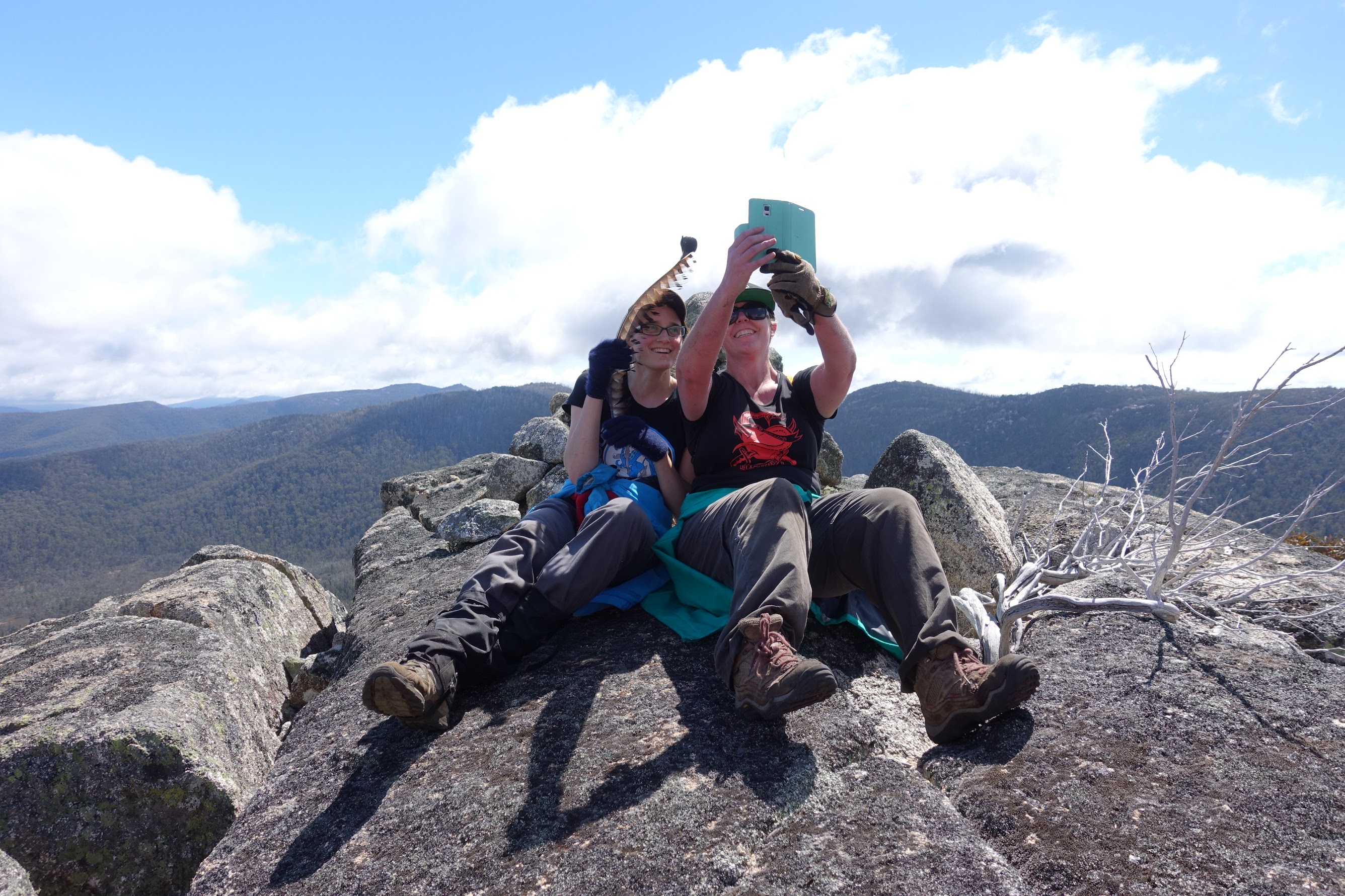
We returned north along the crest, 640m in 45mins. One abortive attempt, then found the cairns and the easy scramble to the top. The trig baggers, waving their newly found and rather magnificent lyrebird tail feathers, were happy. The immediate cloud had cleared, although Bimberi Peak had its head in them. But magnificent views, particularly to the south towards Mts Namadgi and Kelly.
Next, for a hat-trick, we descended from the granite dome of Coronet Peak and took the (relatively) ridiculously easy route via the north of the cap to the west side, where GC1M554 The Princess of Namadgi was logged. 140m in 25mins. Everyone happy! All that was left was to go home.
The descent from Coronet Peak to camp was 2.7km in 1hr 45mins.
We broke camp, had lunch and walkers drifted out when they were ready. A couple of drink stops on the way out. 12.2km in 3hrs 5mins.
Lovely to have some new and younger walkers in the party, as well as old and older friends. Great fun. I don’t envy everyone else having to go to work tomorrow.
Thanks folks, great trip.
Track Maps

Party
9 walkers – Robyn H, Sally L, Trevor L, Stephen M, Lauren O, Lisa Q, Jasmine S, Neil W, me.
Terrylea Reynolds
30 October , 2017 12:33 pmSounds like a fabulous weekend John. I’ve only been to Split Rock once before and that was last winter when it was filled with snow. Good to see it in the clearer weather. The day I went it was bitterly cold. Love reading your posts btw. 🙂
Johnny Boy
30 October , 2017 12:55 pmHi TL. You back in good old Oz yet? Any synergy between your Saturday 11 November and mine? Cheers. john