Keverstone SCA

Tuesday 28 April: Keverstone State Conservation Area – L/R. The reserve is 35 km north of Crookwell. It is a rugged area of about 12 km x 6 km, with steep gullies and ridges covered in dry grassy woodlands. The walk is mainly off-track with numerous steep ascents and descents. There is a 2 hour 15 minute drive each way. Minimum distance: 15 km with 700 metres of ascent. Map: Bigga 1:50,000. Leader: Ian W. Transport: 356 km return. Limit: 8.
7 of us drove in 2 cars via Gundaroo and Crookwell, then on Binda Rd through Binda, Junction Point Rd, Bigga Rd and Wick Wack Rd to where the Dam Circuit Trail leaves Wick Wack Road. Nice to be driven – I slept most of the way there (and back).
Summary
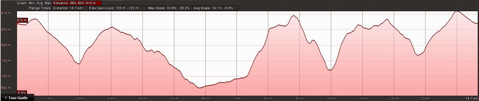
Distance: 14.8km | Climb: 725m | Time: 8.50am-3.15pm (6hrs 25mins), with 60 mins of breaks | Grading: L/R; H(12)
Track Map
Track

Profile
Photographs
Photographs are available, where you can start a large sized slideshow.
gpx File
Download the .gpx file here. (Right click, Save Link As…, Save – if you want to use it.)
kml File
Download the .kml file here.
Track Notes
Another of Ian’s new Crookwell Reserves. Amazing how he finds these places for our walking enjoyment. He played the ‘grand old Duke of York’ today, marching us up to the top of not one hill, but several ridges, and down the other side.
A cool Autumn day, absolutely perfect for walking under blue skies and well warmed by the climbs. Like the other reserves in this area, dry open woodland with plenty of gullies and ridges and a few extra (not map-marked) bits of fire trail. I hadn’t noticed that the OZraster map we were using was 1:50000, so the contour interval was 20m, not 10m.
No particular features, just a pleasant bumpy (see the downs and ups on the track profile) walk.
Thanks Ian and all.
Party
7 walkers – Eric G, Linda G, Ian H, David P, Max S, Ian W (leader), me.
Next Tuesday Walk
Tuesday 5 May: Yaouk Peak – L/R,ptX. A long drive through the south of the ACT to a private property on Yaouk Rd. Farm track and footpad most of the way to Yaouk Peak. Descend 600m off-track via the northern spur. Around 14km and 700m climb. Map: Yaouk. Leader: John Evans 0417 436 877 john@johnevans.id.au . Transport: ~$25 per person.
Sorry, overbooked with 9.
John Hall
29 April , 2015 12:04 amLooks like a great walk John! Thanks for post.
Glad you had the chance to do Frenchmans recently.
Helen and I are off to Eurpoe next week.
Cheers
jh