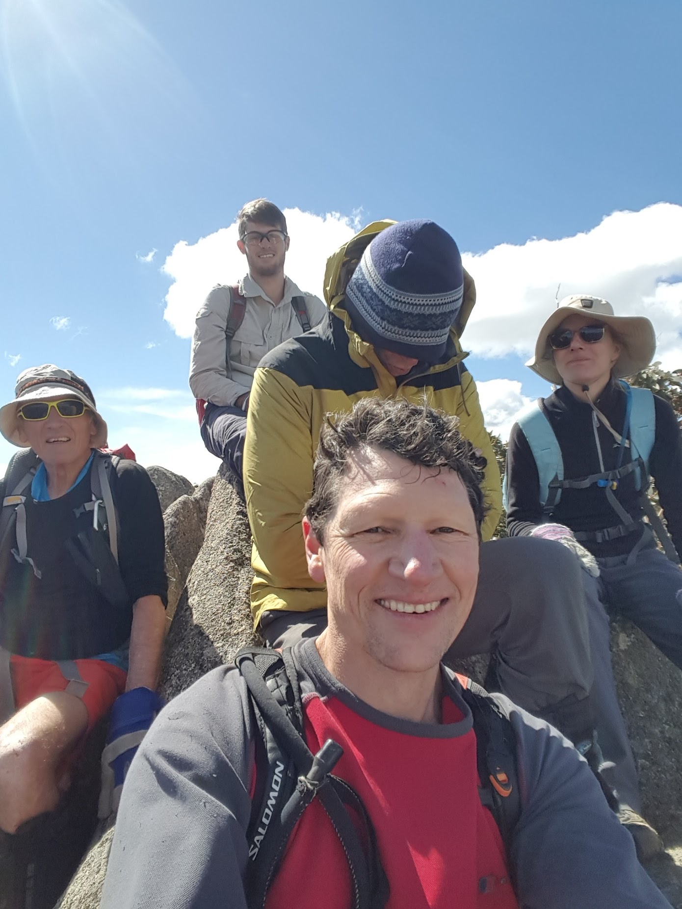
Happy geocachers JohnnyBoyACT, Cankid, Fox in Jox (aka ‘the bulldozer’) and Lokipagan find a Lost Czech Tourist (a little displaced on Mt McKeahnie and theatrically acted by happy Percy-bagging Jonathan) | photo Wayne B
Friday arvo-Saturday 29-30 September: Mt McKeahnie/Dutchies Peak – L/R,X. On the Friday afternoon, we will walk 12km in 3-4 hours from the Orroral car park along Cotter Hut Road to camp at Eighty Acres. On Saturday, we will do a day trip to Mt McKeahnie and Dutchies Peak to indulge the dark arts of Percy bagging and geocaching. Then retrace our steps to retrieve our overnight packs and return to the cars late Saturday. Around 10km and 600m climb, plus the walk out. The trip will suit strong walkers with an appetite (or tolerance) for thick ACT scrub. Walk is exploratory for the leader. Map: Corin Dam. Leader: Jonathan M. Limit: 8. Booking: Please book by Tuesday 26 September.
Further Information
Last time I was at Dutchies Peak was 19 Jul 06 and on Mt KcKeahnie 3-4 Jun 06. I will never return … not even the next time.
Summary
Saturday – Distance: 11.6km | Climb: 510m | Time: 12.45pm – 3.30pm (2hrs 45mins), including 15 mins of breaks | Grading: M/E; M(8)
Sunday – Distance: 20.6km | Climb: 730m | Time: 8.00am – 7.40pm (11hrs 40mins), including geocaching and other breaks | Grading: L/R; H(14)
Photographs
Photographs are available, where you can start a large sized slideshow.
Videos
On Dutchies Peak, if you’d like to retrieve them 😳 .
Well, 18 months later, Nicholas Hall did. Although the camera won’t fire up anymore, I got the pics and video off the card.
Waypoint and Track Files
Download the .gpx file. (Right click, Save Link As…, Save – if you want to use it.)
To use in Google Earth, do File, Open… and select Gps or All files as the File Type.
Track Notes
I declare myself an old man. Took a camp chair for the first time; lost my new $1+K camera (lost the previous one walking with Wayne, so there must be a causal effect); got the runaround from walkers 50, 40, 20 and 10 years younger than me; too much clear air in places for me (now I really know what a ***** difficulty rated geocache is); trailed along in last place except for 15mins out front; and was totally whacked.
Jonathan and I left Canberra at noon on Friday, drove to the Orroral Tracking Station car park and enjoyed (as much as one can a hard fire trail) the walk in along the Cotter Hut Road. Met the local Ranger and had a brief chat. A 15min stop for lunch on the log where the AAWT leaves the Cotter Hut Rd. 2hrs 40mins for the 11.6km and 510vm. It was pretty windy, so we overshot a little to check a camping spot, but in the end returned to the road verge just near the creek culvert. A lone walker passed us as we were setting up camp.
Jonathan did a little recce up the creek line and onto the southern flank of tomorrow’s spur. I sat in my chair – very nice, thank you for the gift, Mike. We were all legal with a camping permit, so no fire in the Bimberi Wilderness. Tea and we twinnies (Tarptent Moments, Exped mats and Western Mountaineering sleeping bags) were in bed by 6.15pm! A wild and windy night (my tent suffered some minor stress damage) with a few showers.
Up at 6am and packed up ready to meet the geocachers riding in. The arrangement was to met them by 8am and they didn’t let us down. We wandered back up the road a couple of hundred metres and met them powering along at 7.45am.
So off we went on the toughest, but also most rewarding, day I’ve walked for a while. Starting at 8am, we crossed the creek to the north of our camp, then sidled up the SE side of the spur towards SH1386. Jonathan found good going, better than we’d expected. A very windy day. Covered the 1.3km in 55mins.
The plan was to keep on the SE side of the crest. At some stage Wayne (the ‘bulldozer’) took the lead and continued out front until the geocaching riders left us in the afternoon.
The next leg took us past a gigantic tor marked with an * on the spur leading to Dutchies Peak. We reached that location at 10.30am, the leg of 1.9km climbing through granite and scrub taking 1hr 40mins.
Using the spoiler pictures from the geocache entry (that’s giving nothing away that the cache is somewhere on Dutchies Peak), we found the start of the crack on the west side of the massive tors. shimmied up it, across the more open area, then more scrambling and air than I normally enjoy. Plenty of granite, above and below, and death-causing holes. Our caching companions were like mountain goats. Thanks for the hand up, Cankid. So GC2BHY8 Lost Czech Tourist found and logged, only the second visit to this cache and after 7 years! Jonathan was pleased too, as this is a Percy.
Most impressed by the geocaching community too. A text a little later from Fox in Jox caused a storm of responses.
I took some photos and videos, packed up my camera, but snapped again a little later up the top … and left it there. One is supposed to leave a swap at a cache, so it’s yours if you can retrieve it before the rain. Doh 😥 .
We were down by 11am, Wayne finding another descent a little to the north of the slot. A 640m leg through scrub and granite to the NW in 40mins to Mt McKeahnie. A quick find and log of GC22HX1 McKeahnie Major. Jonathan was doubly pleased – not only a Percy, but 3 points for standing on the top. Very, very windy and the breeze dropping the temperature dramatically.
Here the cachers took a further leg to the NW. Very difficult and slow going, the 500m taking 1hr 5mins. But another quick find and log of GC2443G Rugged Wilderness. Massive views, particularly to the north where I’ve come in further south of McKeahnie trig. Lunch.
With the benefit of the view back up the hill to Mt McKeahnie, Wayne’s chosen route was a lot clearer and the return was just 35mins!
Back on the hill, we admired the magnificent views that Jonathan had been appreciating. The return was planned, with a leg across the SW of Dutchies Peak. No chance to return to the tors to look for my camera, as time did not allow. 900m in 55mins, but we were well positioned on the SE side of the crest and south of Dutchies Peak.
Here my GPSr chucked its fifth spak attack in as many day’s usage. Thanks to Robyn for her track from here to where the cachers left us. That was 1.2km in 1hr. They then headed SE via another cache to their bikes at the locked gate. (Looking at Robyn’s supplied track, they rode out the 9.7km from there in 32mins!!
That left Jonathan and me. I had a go leading, was forced low by the granite and scribed the ugly loop SE round SH1386. Jonathan then showed me how to do it with compass and took us directly to our camp.
We had a spell, repacked our gear and walked out. Left at 5,25pm and reached the car at 7.40pm. 2hrs 15mins for 11.3km. No torches needed and a beautiful time of the day.
The old car’s breaks worked well on the way home and a big boomer escaped (so did we).
A wonderful trip. Thanks Jonathan. And to Wayne, Hugh and Robyn – you folk are tough and quick!
PS. Lucky I’m with AAMI!
Track Map

Party
5 walkers – Wayne B (Fox in Jox) (also da man bulldozer), Hugh C (Cankid), Robyn H (Lokipagan), Jonathan M (leader), me (JohnnyBoyACT).