Punch Bowl Creek and Blythburn Cottage

Saturday 29 August: Punch Bowl Creek and Blythburn Cottage – M/M,ptX. From off the Corin Rd, walk old fire trails to the top of Punch Bowl Creek. Follow a footpad (it was there in 2007) down through White Horse Flat onto the Booroomba property. Permission has been granted by the land owner. Visit Blythburn Cottage, the location of Elizabeth McKeahnie’s all-female dairy and cattle station. Loop back via vehicle tracks visible on Google Earth but not known to me. Around 16km and 400m climb. Maps: Corin Dam and Tidbinbilla. Leader: John Evans 0417 436 877 john@johnevans.id.au . Transport: ∼$10 per person.
10 of us drove in 2 vehicles, via Tharwa as Point Hut Crossing was closed, to the old Smokers Trail turnoff on Corin Road. We parked there.
Summary
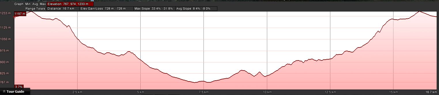
Distance: 16.9km | Climb: 730m (from Google Earth) | Time: 8.55am-2.45pm (5hrs 50mins), including 45mins of breaks and the look round Blythburn Cottage | Grading: L/E-M,ptX; M(11)
Photographs
Photographs are available, where you can start a large sized slide show.
Video
Waypoint and Track Files
Download the .gpx file. (Right click, Save Link As…, Save – if you want to use it.)
Download the .kml file.
Track Notes
Great to get back to walking after 11 days off due to rainy weather. Although not too sure as we gathered at Kambah in the bitter wind and saw black clouds to the west. But, try to forecast, the day came good and it was a lovely late winter’s day under blue skies.
A detour via Tharwa on the way out. I’ve never seen the Murrumbidgee River so full.
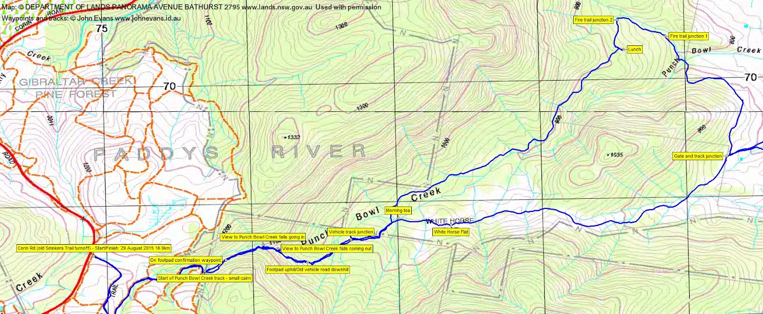
We parked at the gated off start of the fire trail to the Smokers Trail trackhead and negotiated the curves of the fire trails in the area to get us to the boundary between old pine forest and native timber at the top of Punch Bowl Creek. I was wrong about the Namadgi National Park boundary here – it is the park boundary, but we were entering the Park (at least on my old 2006 vintage digital maps).
The second thing I missed, by not walking another 5 metres up the fire trail, was a small cairn marking the start of the Punch Bowl Creek footpad. No real dramas, as we crossed a drainage line, went a little south and high, but picked up the footpad after a couple of hundred metres. It is a footpad here, a little crowded by shrubs in places, but benched.
After a while we caught our first glimpse of the Punch Bowl Creek falls, roaring with water after the recent rain (on 17 Jul 07 they were iced). The fall off the side of the footpad was severe, but after another 100 metres, three of us couldn’t resist the temptation so doubled back and sidled down for a view of the falls. Magic! We returned straight back up to the track.
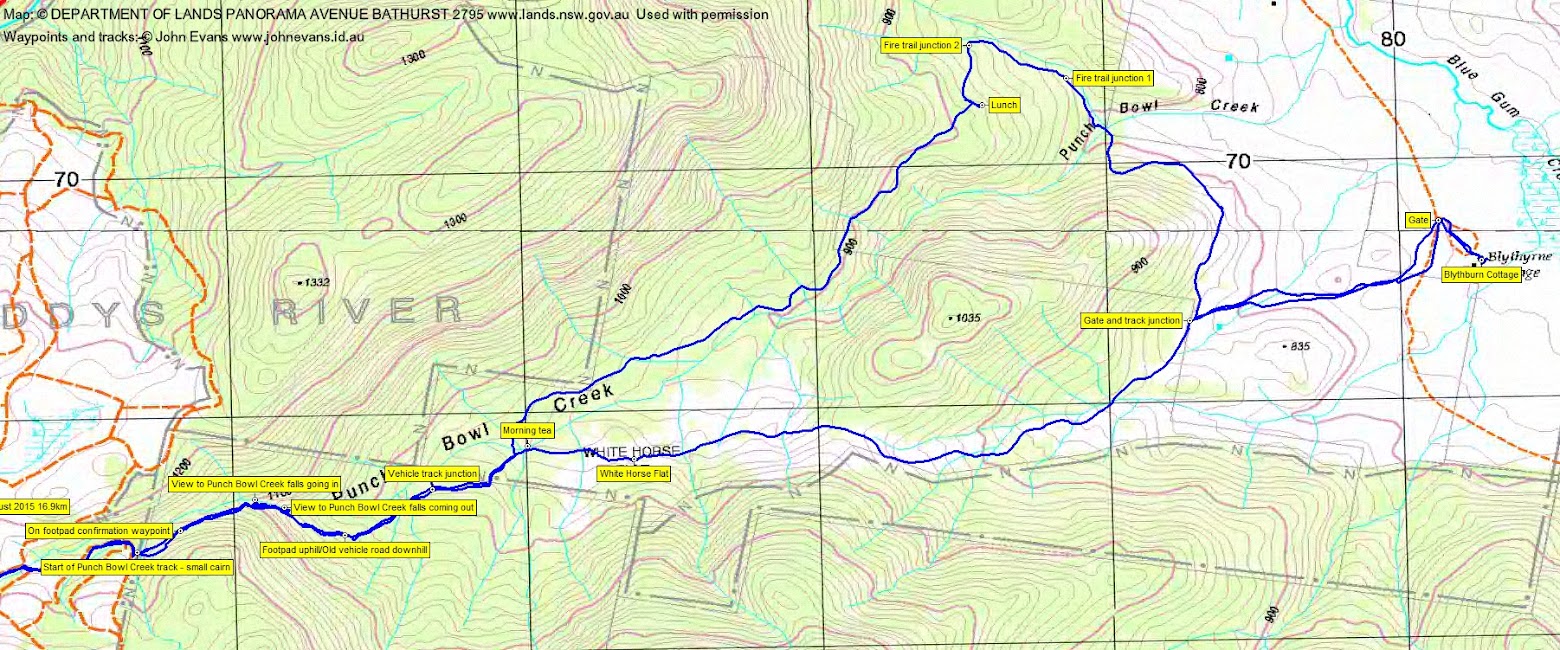
Continuing down the footpad, the down began to ease off and the pad became an old track. I’ve marked this point. Further on and easy walking, we came to a gate through a fence line and the first of several large wild pig traps. It was here I planned to return from across the other side of Punch Bowl Creek, so we nipped down a few tens of metres to check that we could cross the creek at this point in the afternoon. Back to our descent, we came out of NNP onto the Booroomba property and stopped for morning tea on Punch Bowl Creek in the sun. Nathan tweeted up a storm with a very nice photo. The breeze stopped before I could call 5 minutes and the smell of dead pigs by the second trap drove us out from morning tea.
Wet underfoot, especially as we entered White Horse Flat. None of them, just black cattle. The old vehicle track continued to provide easy and uneventful walking as we headed towards the open Blue Gum Creek valley and the pasture land of ‘Booroomba’.
A gate gave us access down towards our objective and a short detour to the north took us along a fence line to another gate and so to Blythburn Cottage. Jenny gave us the history of the place, Margo added information from here. We had a good poke around.
We retraced our steps to the gate and track junction and began our homeward leg along the vehicle tracks I’d seen on Google Earth (not marked on any maps). Not terribly exciting, but perhaps better than returning the same way as we came in. Nice views to the Booroomba buildings complex as we sidled towards a crossing of Punch Bowl Creek, then a curve around to a nice spot on dry rocks just off the track for lunch.
Another fairly boring leg along the true left side of Punch Bowl Creek, but great company and chatter. Quite a number of trails in the area and we took an unplanned one down to re-cross Punch Bowl Creek and join our inward route just uphill from morning tea.
Another opportunity to view the falls as we climbed out. At the same spot as in the morning, so I thought, but the track on the map shows different. My mistake, but it shows how extensive the series of Punch Bowl Creek falls really are.
Jenny led us home and, I must say, perfectly along the upper footpad to the marker cairn. A stroll back to the cars.
A pleasant and easy trip, apparently enjoyed by all as party members had not been to Blythburn Cottage. Thanks everyone for your company.
Note that, recognising the NNP boundary, one can walk from Corin Road to Punch Bowl Creek falls, a fraction over 2km, in less than an hour. A nice little destination when the water is flowing (or frozen).
From just above White Horse Flat you are on the Booroomba property and permission to walk there should be sought from the land owner.
Timings
| From | To | Distance | Time |
| Corin Rd | Start Punch Bowl Creek footpad | 1.6km | 20mins |
| Start Punch Bowl Creek footpad | Morning tea | 1.8km | 50mins |
| Morning tea | Blythburn Cottage | 4.0km | 1hr |
| Blythburn Cottage | Lunch | 3.5km | 1hr |
| Lunch | Re-join track | 2.5km | 40mins |
| Re-join track | Start Punch Bowl Creek footpad | 1.8km | 45mins |
| Start Punch Bowl Creek footpad | Corin Rd | 1.6km | 20mins |
Track Maps
Track overview

Track 1
Track 2
Profile
Party
10 walkers – Margo C, Rob D, Nathan H, Jenny H, Jonathan M, Terrylea R, Barrie R, Llewellyn S, Imaina W, me.
Next Saturday Walk
Saturday 5 September: Glendale Drystone Walls and the Billy Range– M/M-R,ptX. From the Brandy Flat Walking Track northern track-head, climb 300m to the north through a little scrub to visit the amazing drystone walls. Does anyone know why they were built? Find geocaches GC1W3E8 Getting Stoned and GC1W57N Passing Stones. Then north-east to climb onto the Billy Range. Return via a spur to Reedy Creek and so to the Brandy Flat fire trail. Around 12km and 750m climb. Map: Michelago. Leader: John Evans 0417 436 877 john@johnevans.id.au . Transport: ∼$12 per person. Late bookings welcome.
Linda Groom
30 August , 2015 8:56 amA very creative route!
Johnny Boy
30 August , 2015 9:16 amWell, in the end it was follow the vehicle tracks, so not too much creativity on my part. Lovely to see the Punch Bowl Creek falls up close and the others had not been to Blythburn Cottage. So a good day, despite me (grin).