View from Mt Tennent – Deadmans Hill, Booroomba Rocks and Blue Gum Hill

Saturday 3 January: Cbr100Challenge Training – Mt Tennent – L/E. A quick (as quick as I can go at the moment) trip up Mt Tennent. Around 14km and 800m. Approximately 3 and a half hours. Map: Williamsdale. Leader: John Evans 0417 436 877 john@johnevans.id.au . Transport: Drive yourself to meet at the Namadgi Visitors Centre outer car park at 7am. No need to book, but please contact me if you need a lift and I’ll try to assist.
6 of us met.
Summary
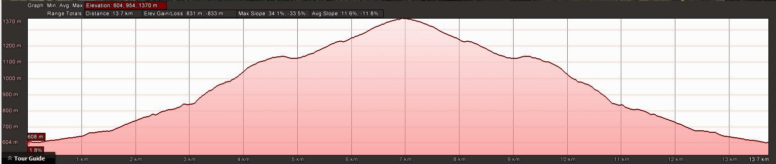
Distance: 13.8km | Climb: 830m | Time: 7.00am-11.10pm (4hrs 10mins), with 20 mins of breaks | Grading: L/E; M(9)
Track Map
Track

Profile
Photographs
Photographs are available, where you can start a large sized slideshow.
gpx File
Download the .gpx file here. (Right click, Save Link As…, Save – if you want to use it.)
kml File
Download the .kml file here.
Track Notes
So the Cbr100Challenge training schedule for week 2 says ‘Strong hard walk approx. 1 hour’ for Saturday and ‘long walk approx. 4 hours or 20km’ for Sunday. Perhaps this little ramble was somewhere in between.
I knew Trevor was coming, but grateful for the extra company and pleasantly surprised when 6 of us headed off. Certainly the right time of the day to be starting; those on the way up as we neared the end coming down would have had a hot trip.
Maurie turned out to be a cacher (we’ll turn CBC to the dark side yet!) and it was the first trip up Tennent for Michael and Margaret.
A few others on the hill.
The view towards Canberra was a bit hazy from the top, but clear to the south-west and west over Deadmans Hill, Booroomba Rocks and Blue Gum Hill. To the south we saw the Clear and Booth Ranges, and Mt Gudgenby on the horizon. The Tinderrys in the distant east.
Hi to the blog reader and her companion that I met as I was waiting at the T-intersection on the way down.
A cool drink at the Namadgi Visitors Centre was just the ticket.
Party
6 walkers – Berlinda B, Maurie D, Trevor L, Michael and Margaret T, me.