
Saturday 3 June: High Hills East of Gibraltar Creek – M/R. We drive to the Corin Dam road, near to Woods Reserve. We then walk off-track down to Gibraltar Creek, then up spurs to the unnamed high hills to the east of the creek. We then proceed north east along the tops for a few kilometres before dropping back down to the creek and the road again. This is rough, rocky, scrubby terrain. Around 11 km and 700 m climb. Please advise leader of intention to participate by COB Thursday 1 June. Map: Tidbinbilla. Leader: David D. Meet at Kambah at 8:00 am. Transport: 90 km ($10 per person).
Further Information
When the walk was announced, the generous leader was happy to choose a route that included a few geocaches. The walk was shortened on Saturday morning to fit other commitments, but still a great workout.
Summary
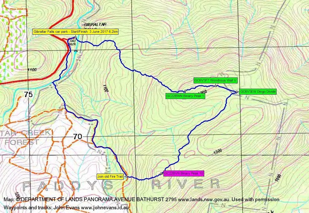
Distance: 6.2km | Climb: 425m | Time: 8.45am – 12.50pm (4hrs 5mins), including 20 mins of breaks | Grading: S/R; M(10)
Photographs
Photographs are available, where you can start a large sized slideshow.
Waypoint and Track Files
Download the .gpx file. (Right click, Save Link As…, Save – if you want to use it.)
To use in Google Earth, do File, Open… and select Gps or All files as the File Type.
Track Notes
Pretty cool when we stepped out of the car at Gibraltar Falls. One of David’s COG friends was already there, spotting birds.
We stepped across Gibraltar Creek and into a band of shrubs. The thorny Bursaria was a bit tough on cold knees, but we soon got above it. Medium scrub on the 330m and 1.6km climb to the first high hill, taking 1hr 10mins. David is a great bulldozer!
It took us a while, but Roger eventually found GC22BWN Binary Peak 1. Easier going across the top of the hill to the next cache, 315m in 10mins. I was leading and wondering if we’d end up on the top of a little cliff, but the wall in geocache GC6V3F7 Wondrous Wall V was quite different – the old dog-proof fence. The next cache was straight down the fence line and David found it for us. GC6V3EW Dingo Divide logged.
Now the fear (reverence) of the Lord … (Proverbs 9:10) is a wonderful thing and … is the beginning of wisdom. However, the fear of your wife is another thing all together. David had an appointment back in town, which he knew about, and received a reminder call from his wife. A quick look at the map and we reckoned we could make another cache 1.2crow-lometers away. I’ve never seen David walk so strongly before! He took off like a bulldozer on steroids and we made the 1.3km across the ground in 45mins. Or maybe it was that geocaching got into his blood (not).
I have no fear of my wife (not) and will even admit to losing my glasses ($20 magnifiers thank goodness). But she won’t read this, so I’m safe.
Roger and I, with some help from David, spent 20 minutes looking for GC22BVN Binary Peak 10. As with my glasses, no joy. And with the time ticking away, we had to give up. No morning tea, to boot.
A helter-skelter descent of 140m over 375m in 20mins to hit a decommissioned fire trail. This turned into good fire trail after a while and, when it started to bend away to the Corin Rd, we popped off-track down a convenient spur to cross Gibraltar Creek around 500m upstream from the car.
A combined bush-bash, animal trail and, eventually, onto the old road bench to get us back to the car.
A great little trip, thanks David and Roger. But will have to return to that cache some time. A bit disappointing that, in a party of 3, there were only 3 GPSrs and 3 PLBs 😉 .
Track Map
Party
3 walkers – David D (leader), Roger E, me.