Eucalypt grass

Tuesday 3 March: Nadgigomar Nature Reserve, Western Section – L/M. The walk is in the Sunset Mountain section of Nadgigomar Nature Reserve 35 km north of Braidwood. The terrain is hilly or slightly undulating and there are extensive mature, dry sclerophyll woodlands. A fire has recently burned through some of the reserve and our route will take us in and out of burnt areas. The route is mostly off-track. Minimum distance: 18 km with approx. 400 metres of ascent. Map: Oallen. Leader: Ian W. Transport: 192 km return. Limit: 8.
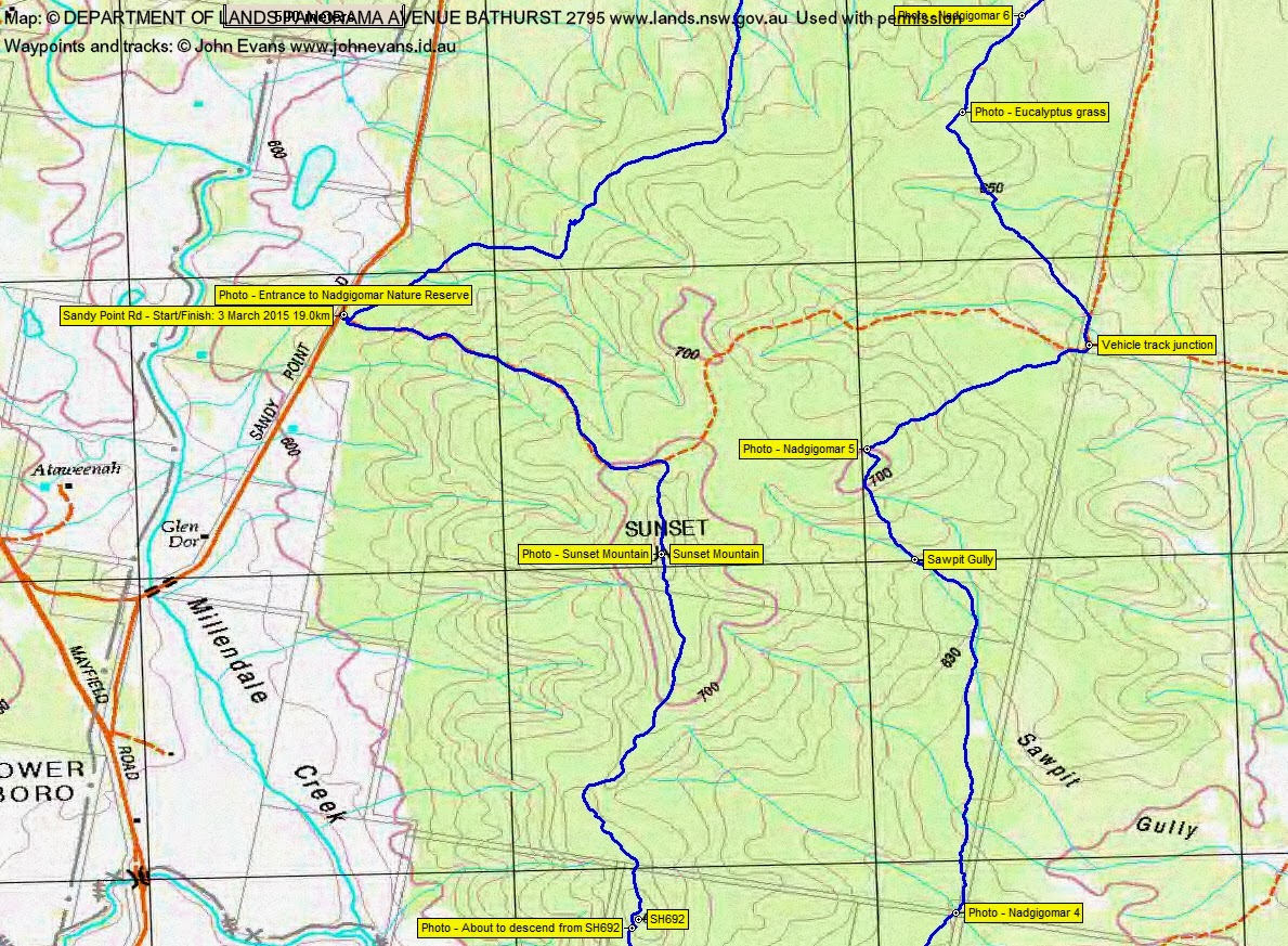
3 of us drove via Queanbeyan, Tarago, Lumley Rd, Mayfield Rd and Sandy Point Rd to park opposite the entrance into Nadgigomar Nature Reserve.
Summary
Distance: 19.0km | Climb: 470m | Time: 8.30am-2.50pm (6hrs 20mins), with 25 mins of breaks | Grading: L/M; M(11)
Track Maps
Track overview

Track 1
Track 2
Track 3
Profile

Photographs
Photographs are available, where you can start a large sized slideshow.
gpx File
Download the .gpx file here. (Right click, Save Link As…, Save – if you want to use it.)
kml File
Download the .kml file here.
Track Notes
Around 1hr 20mins to drive from Woden. All sealed road, except for the last maybe 7km, which was good dirt.
This was a great walk! Lots of different land forms and plant cover. The southern part of the walk had a few more ups and downs; the northern section was pretty flat. Whilst the predominant vegetation was Brittle Gum woodland, we also had moist drainage lines, grass trees, she oaks and a spectacular area of ‘eucalypt grass’ – rampant short regrowth following a controlled burn in early 2014. Although only knee to waist high at the moment, we wondered how high they’ll be in a year or so and how difficult to traverse.
I’ve included quite a few photos of the various different types of vegetation and labelled the point of the photo on the map segments.
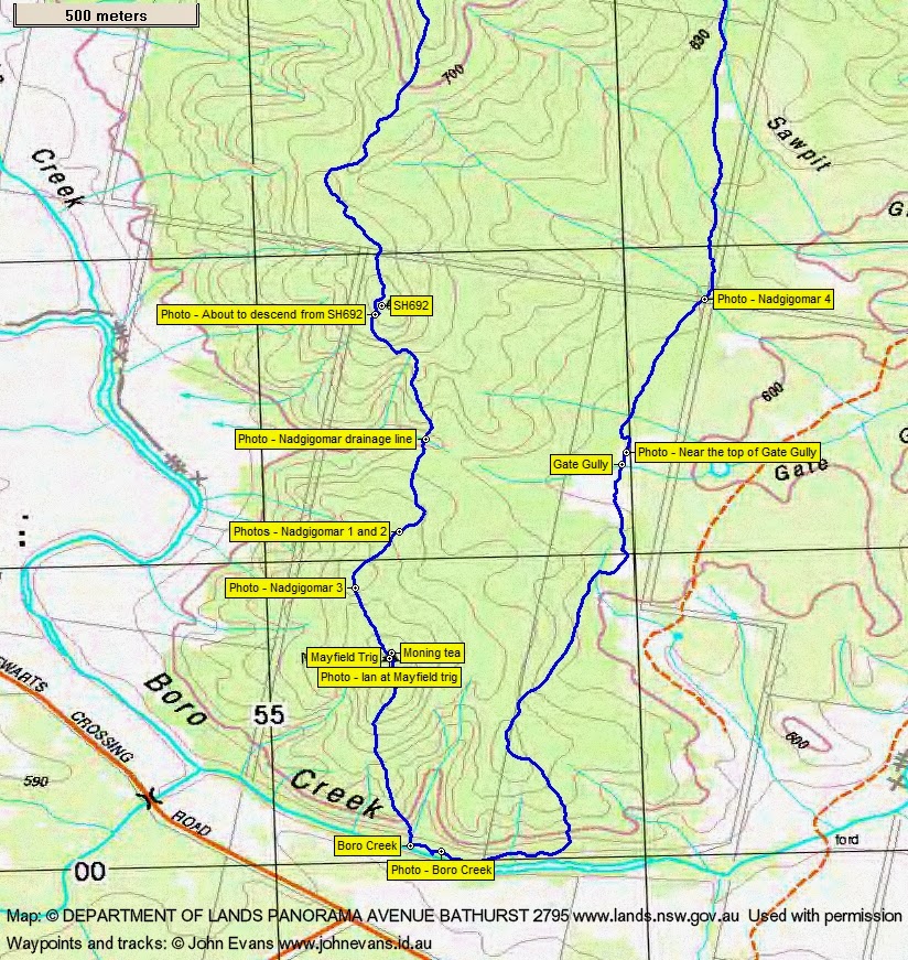
We followed the Sunset Mountain Trail in for a bit, as Ian warmed up his broken body. Turning south off the track, we ‘bagged’ the most un-prepossessing Sunset Mountain. We continued south along a few downs and ups to arrive at Mayfield trig for morning tea. 4.4km in 1hr 20mins.
The next leg took us down to Boro Creek. We walked that area for a while, then returned up to the dry eucalypt woodland and headed generally north. The top of Gate Gully was shrubby and a little further on nice grasses underfoot.
At 12noon we crossed Sunset Mountain Trail. The leg from morning tea to here was 5.8km in 1hr 55mins.
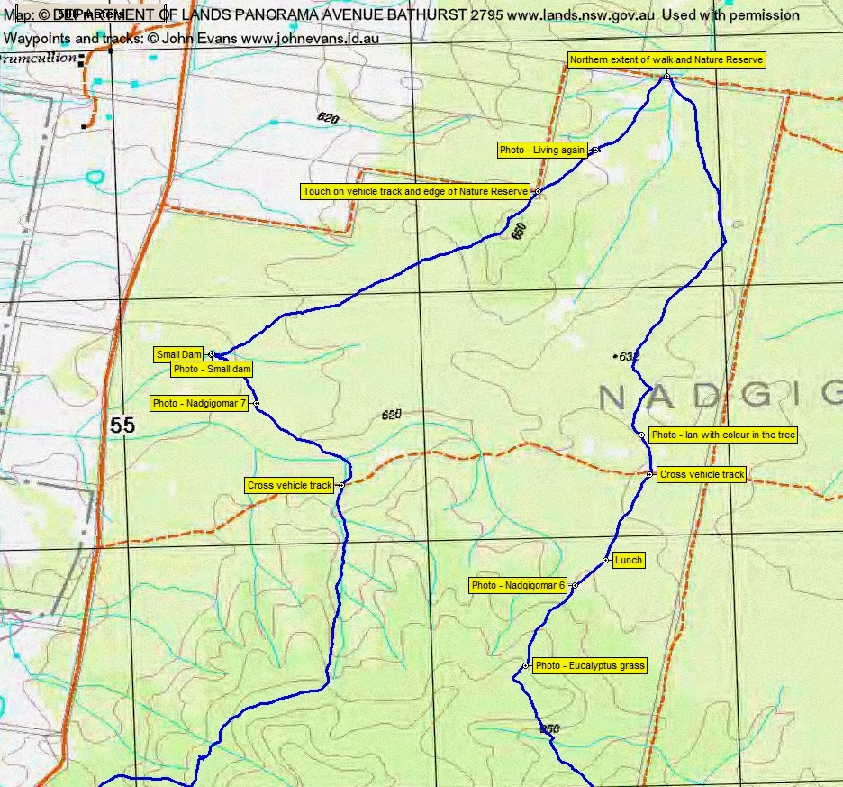
Around 500m NW of the Trail we ran into the area of dense eucalyptus seedling regrowth. Most interesting – none of us had seen anything like this before. An area of dry, sandy soil (which the controlled burn had missed) took us to lunch. 1.5km in 35mins.
A little warmer out in this part of the NR with less shade and the sun breaking through. But most of the time we enjoyed cloud cover and mild temperatures. Continuing north we crossed another vehicle track. Lovely colour in the tree trunks. North of SH632 it was pretty flat – we crossed one contour line (but couldn’t see it on the ground). From lunch to the northern extent of the walk was 2.2km in 33mins.
Ian H enjoyed 5m on the fire trail, then we struck off into the light bush again. Our next leg took us 2km in 33mins south-west to a small dam.
From here it was 3km in 1hr SE, S and SW back to the car.
An excellent little walk! If anyone would like to inspect this area, but would like to do less than 20km, then Sunset Mountain Trail and the other more northern east-west vehicle track would make excellent bounds for a shorter walk.
Party
3 walkers – Ian H, Ian W (leader), me.
Next Tuesday Walk
Tuesday 10 March: Cbr100Challenge Training – Walk the 25km route – L/E. It’s getting close, so best to maintain walk fitness. Westside@ActonPark – Black Mountain – Scrivener Dam – Red Hill – Melbourne Avenue – Commonwealth Ave bridge. Around 25km and 675m, starting 6.20am. Map: Canberra. Leader: John Evans 0417 436 877 john@johnevans.id.au . Transport: Drive yourself. Late bookings welcome.