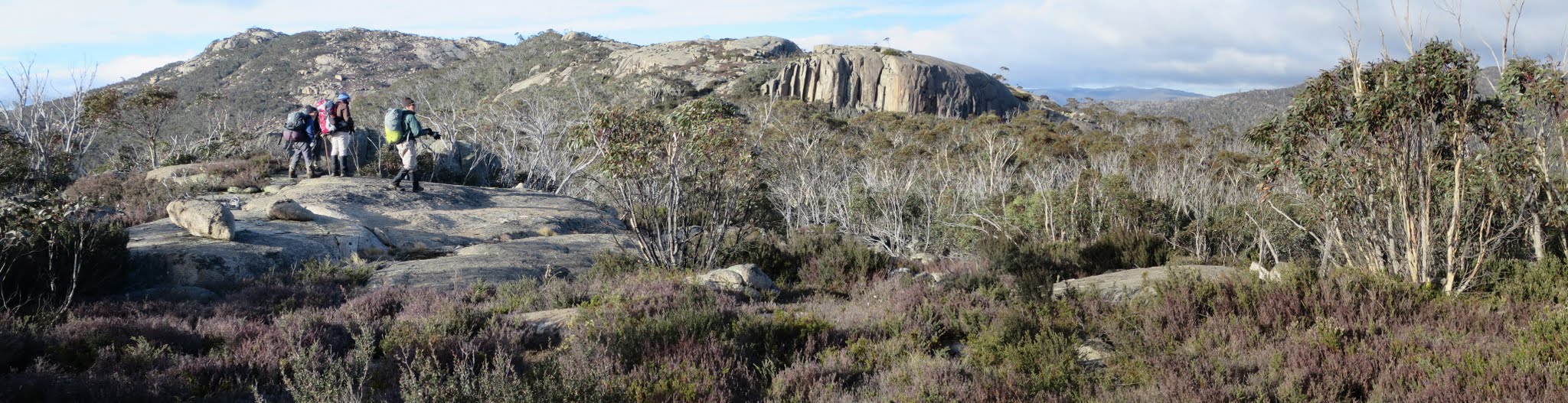
Walking the SE Scabby Range – view from near BM J82
30-31 May 2015: The Fortress and Sams Creek – M/R. This is a reconnaissance along the ACT border between the saddles south of Kelly and north of Gudgenby. Some difficult scrub and terrain. Maps: Rendezvous Creek, Yaouk. Leaders: Jenny & Rob H. Transport: $40 per vehicle.
5 of us drove in 2 cars to the Yankee Hat car park.
Further Information
My notes: Day 1 – Yankee Hat car park via SE Gudgenby saddle and Sams Creek FT to below Mt Kelly. Pick up water and ascend via gully to border on crest of Scabby Range at GR 55H FA 707439 (MGA). Around 18km and 750m. Day 2 – border marker hunting S along the border and over ‘The Fortress’ at 1730+m. Scrub and granite. Descend to north Gudgenby saddle, then down to rejoin Sams Creek FT and so home. Around 17km and 350m. Sun times for 30 May are: 0634-0702-1700-1728. Sun times for 31 May are: 0635-0703-1700-1727. So 10hrs of daylight.
Summary
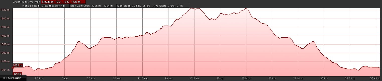
Distance: 37.4km | Climb: somewhere between 1325m (Google Earth) and 1740 (GPSr) | Time: 2 days – 9hrs 10mins + 10hrs 10mins | Grading: L/R; H(13+)
Track Maps
Track overview
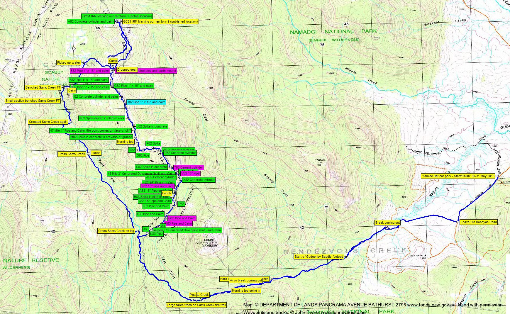
Track 1
Track 2
Track 3
Track 4
Profile
Photographs
Photographs are available, where you can start a large sized slideshow.
Video
There’s no sound but the wind
Waypoint and Track Files
Download the .gpx file here. (Right click, Save Link As…, Save – if you want to use it.)
Download the .kml file here.
Track Notes
What makes a walk an epic? Is it because, as one ages, all walks are harder so therefore epic? Or, as one ages, does one attempt the epic walks before boots are hung up?
This walk was definitely an epic! As well as the above it gave huge views, extremely difficult going and challenging weather. It also yielded my first ‘first to find’ (FTF) geocache and the last of the southern ACT border markers, on what may well be my penultimate border marker hunting trip.
Huge thanks to Rob H for putting on the walk – I was too wimpy to go up there without him. And what do you do if you have the opportunity to log a geocache, but you don’t have the location with you? You take the cache owner, of course! So huge thanks to BorderTrekker (aka Stephen G) too.
A safe drive out (and back) with no animals or vehicles damages. A car already there – great to run into Hayden B and a mate, about to pop up to Mt Gudgenby then go round to camp at Lutons Crutching Shed.
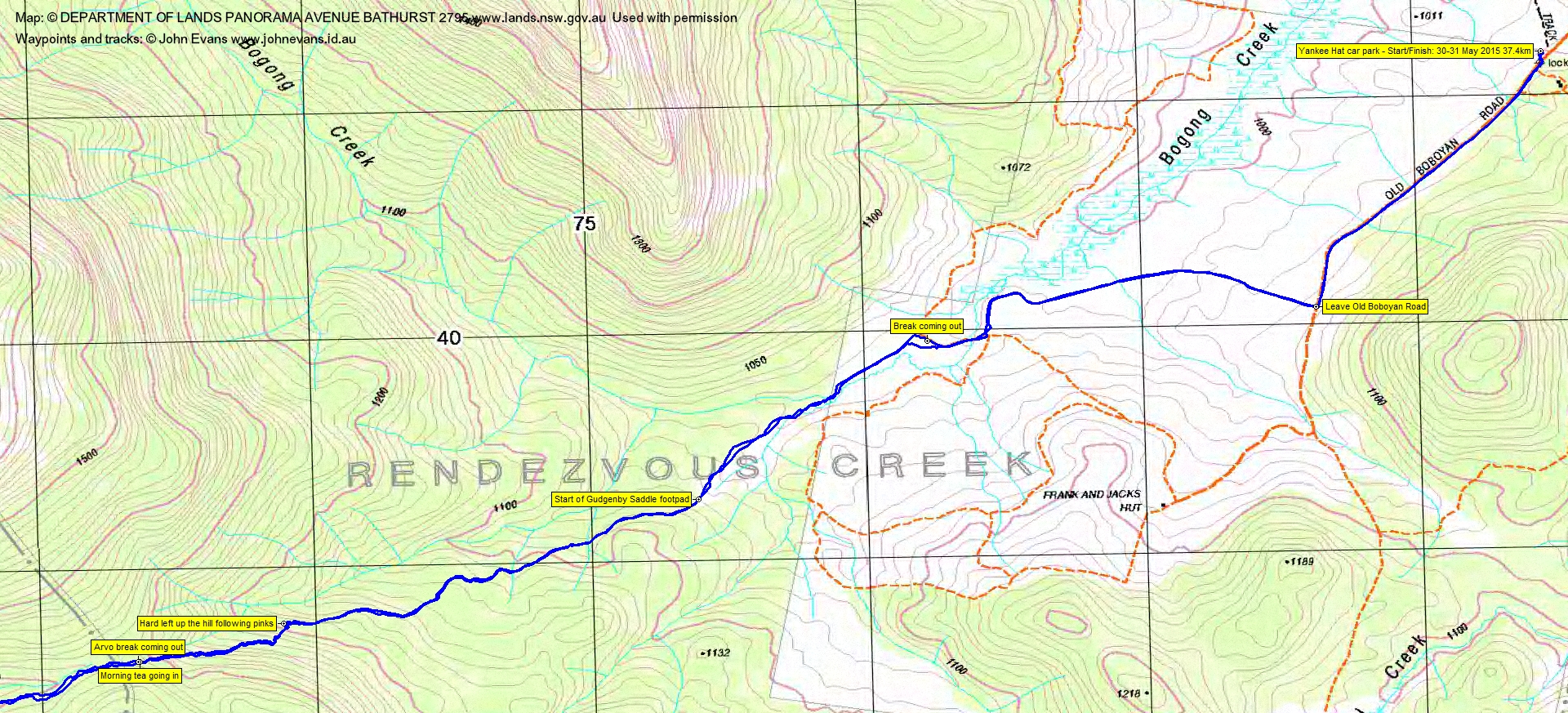
An uneventful 4.3km in 55mins to the start of the Gudgenby Saddle footpad via Rob’s Bogong Creek route. It was quite cool as we started out, in beanies and gloves. I had on 5 top layers but we soon warmed. A budget dance of the seven veils saw 3 of my five tops removed at some stage.
2.4km in 55mins to the Saddle. Perhaps a few fewer tapes along the bottom section, but some nice bright orange ones towards the top and maybe a few more cairns. Hayden and mate arrived as we were having morning tea, they’d come in via Frank and Jacks Hut.
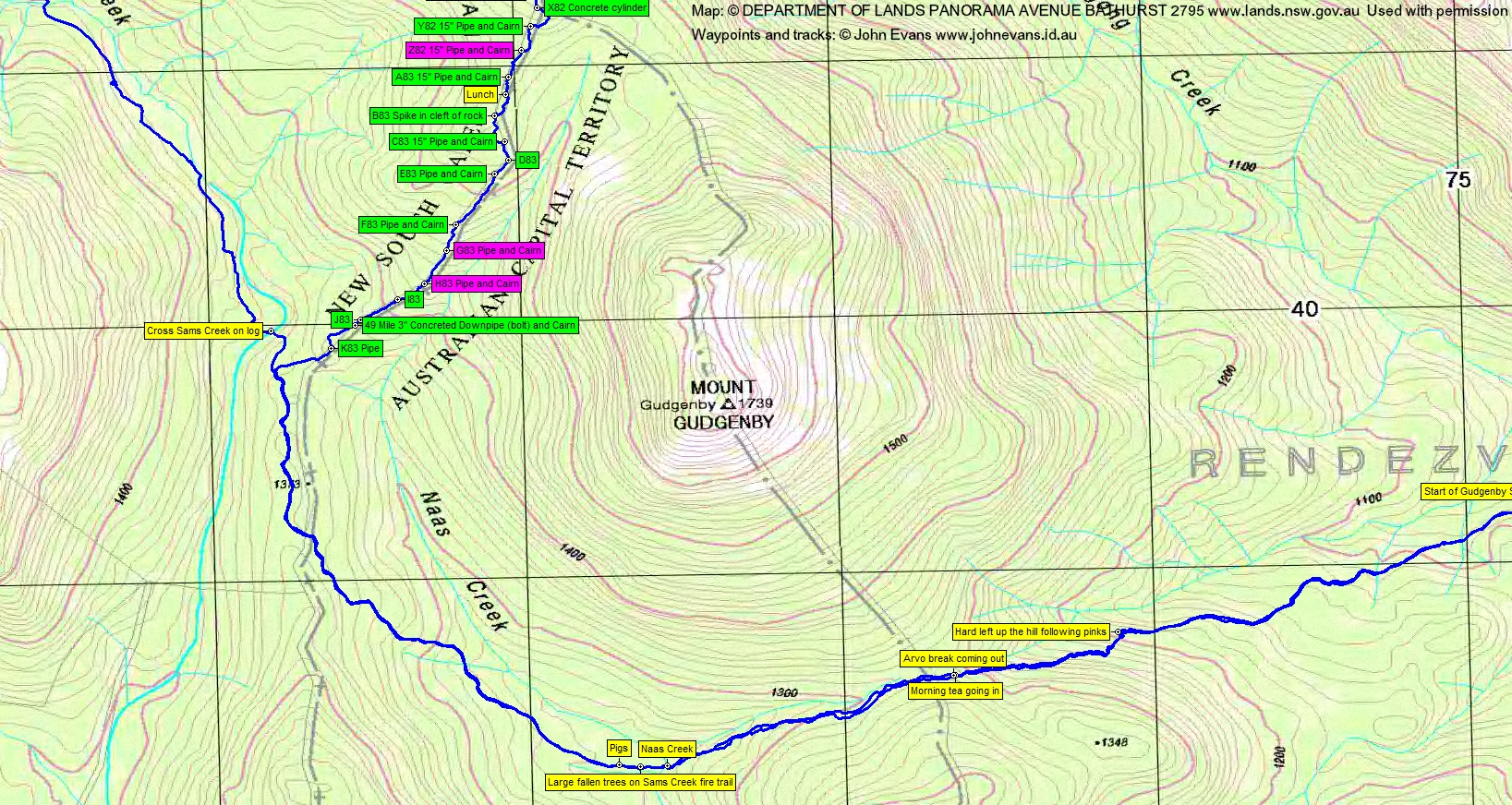
The next leg took us down to cross Naas Creek, around the SW of Gudgenby and to cross Sams Creek. 3.6km in 1hr 20mins. A quick sip of water.
Rob had already come into his own by unerring navigation. No one knows this part of Sams Creek Fire Trail better than he and it is becoming very difficult to discern. It’s very easy to trail along behind the leader with GPSr full of locations on the Fire Trail from previous trips; it’s another thing to pick up the line of the Fire Trail by reading the lie of the land and other signs. From the first crossing of Sams Creek to lunch at the second crossing was 2.5km in 1hr 5mins. Lunch in as much sun as we could find.
Away again at 1pm. We took a higher, westward arc around the Sams Creek yards site, then crossed Sams Creek for the last time. Some trouble picking up the Fire Trail alignment here (the 1st edn Rendezvous Creek map shows it on the west side of the creek, but there were thoughts that it could be down closer to the creek on our east side). Anyway, we eventually picked up some obvious benching and had a good run for 500m or so.
The old map shows Sams Creek Fire Trail continuing in a northerly direction, but there is a footpad which turns east and north up past a little cairn, then north-east on the side of Sams Creek to another of Rob’s spots where we picked up water. From lunch to the water spot was 3.2km in 1hr 40mins.
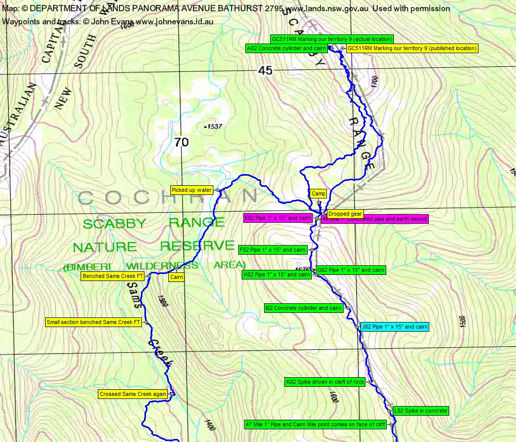
Stephen had been talking about a foray to his geocache GC511RM Marking our territory 9 if time allowed and he was willing to accompany me. So after picking up our water we missed the short break with the others and set off up to the saddle. A little slower with an extra 4kgm of water on board! 40mins for the 850m up across the ground. Nice to see water in a couple of little tarns (the saddle was dry when we came through here on 14-16 Mar 14).
We dumped most of our gear where the others would see it and set off north up the Scabby Range at 3.20pm. Stephen is a big guy and has 10 foot legs up to his armpits. I got a bit of my own medicine back as I panted after him. It was me accompanying him, not vice versa! It was pretty rough going and we had to be back before night fall. On Stephen’s memory alone, we headed up the crest to the 1733m (marked on the 1st edn map) feature above Bogong Gap. It was bitterly cold in the westerly wind, but my blood was running hot for a geocache and not having to ever come back. We got to one tor feature and had a brief look, but Stephen decided no. I was able to get my phone going and, via the Geocaching app, find that we had 66m to go to the next tor block. Phone then conked out in the cold, even though it had plenty of charge.
On we went and Stephen recognised the cache location. Is this cheating, taking the cache owner with you? I did contribute via my phone! This was Stephen’s third visit to the cache and my second, but as it had now been published, I was able to claim a first to find (my first FTF). The leg in was 1.7km in 50mins.
A note on the location. The published location is off-set (for a good reason). The cache is VERY near to border marker A82, which is at UTM 55H 670888-6045152 (MGA). In geocache speak S 35º 43.367′ E 148º 53.362′.
We left at 4.15pm and got back to our gear and nearby camp site at 5.10pm, just on dark.
A welcome fire was going. I chose to camp out off the edge of the tree line (didn’t like the combination of wind and large trees above). Tea and a brief chat before the usual drill – to bed around 7.30pm, a couple of hours of music and a surprisingly warm (in my bag with most of my clothes on) night. Windy and scudding clouds overnight.
Up at 6.30am. The disadvantage of my chosen tent site was the amount of frost to be wiped and shaken off the tent. I won the personal battle of the bladder. Breakfast in bed, then pack up to leave at 8am. The little tarns nearby were iced over.
So my objective for the day was to follow the border south along the crest of the Scabby Range, across the top of the Fortress at 1730+m and down to rejoin Sams Creek Fire Trail. We started at the locations of border marker E82 and the 46 Mile marker (which we couldn’t find on 14-16 Mar 14 and couldn’t find this time) and I needed to finish at border marker S82, the location of which we’d visited on 28 Sep 10. That would complete visiting all the border marker locations in the SW of the ACT and join up the border walking lines. Easier said than done!
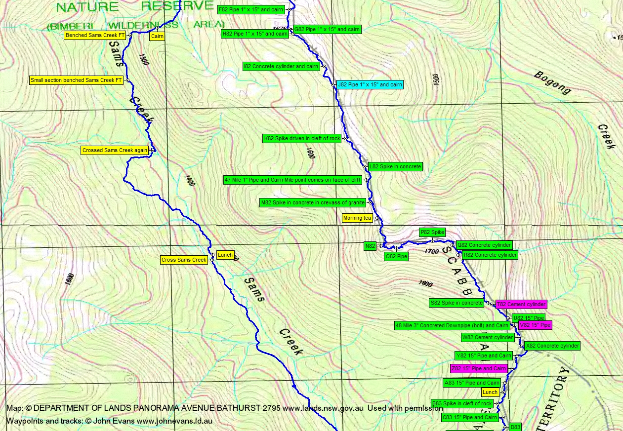
Climbing to SH1676 we found F82 and G82 and, coming off the top, H82. The view south was staggering – granite slabs, tors and cliffs with tight scrub in between. The wind was howling – Mt Ginini at 1760m recorded wind gusts to 46kph and the apparent temperature at 8.30am was -10.4ºC. I82 was a lovely straight lockspit with intact concrete cylinder and survey point nail. J82 was an unlikely find.
I was keen to see K82, described in the original field notebook as ‘Spike driven in cleft of rock’. That’s a similar description to W57 at Mt Gingera, which I’ve not found on several visits. And there it was, a railway spike under the centre of the lockspit.
The weather was still sunny but with clouds starting to roll in. The wind speed had increased and the temperature not risen. Ice on the pools was thick! Wonderful views all round, including SE across the top of the Yankee Hat ridge down to the Gudgenby grasslands. We could almost see the cars.
L82 was another spike. The 47 Mile marker, like most mile markers, a cairn. M82 was easily spotted, a long lockspit atop the granite.
Morning tea was thankfully called, in the lee of the crest. From the start to here was 2.4km in 1hr 55mins. A chance to pick up emails and tweet, once I got the phone going via a kick from my supplementary battery pack.
Away at 9.55am and we began the climb to ‘The Fortress’. N82 is a wonderful marker, sitting high up on a boulder. Not to be missed, it marks a right angled bend in the border. A difficult and slow climb to O82. Further east revealed P82.
Q82 is atop ‘The Fortress’, with magnificent views. And thanks to Matthew Higgins who commented that our trip was a real homage to Harry Mouat and that when he and his party did this part of the border in 1996 they considered that a peak should be named after Harry and it is the ‘Fortress’ that was picked as that peak. So, from now on, Mt Mouat!
From morning tea to Q82 was 860m across the ground in 45mins.
R82 is SE and just down from the top. The lockspit points right at Mt Gudgenby. Both Q82 and R82 have concrete cylinders marking the border corners.
We descended to S82, which I hadn’t found last time, but now here it was. At last, previous border marker hunting tracks joined! From Q82 to S82 was 620m across the ground in 50mins. Very slow going through dense bush and boulders.
Couldn’t find T82. A run down to west of the north Gudgenby saddle and SW from there to lunch yielded U82; no V82; 48 Mile marker; W82; X82; Y82; no Z82; A83. The border south of S82 had been covered before. From S82 to lunch was 1km in 1hr 10mins. A little sleet as we began lunch, with the weather closing in from the NW.
We continued our run south down the border to rejoin Sams Creek Fire Trail. Saw B83; C83; D83; F83; no G83 or H83 (didn’t really care); I83; J83; 49 Mile marker; K83. From lunch to Sams Creek Fire Trail was 1.7km in 1hr 20mins.
A little drizzle as we turned for home on the Fire Trail caused shells to come out.
An uneventful trip back, except for the sighting of a herd of wild pigs just before the large fallen trees marker where we turn to cross Naas Creek. The exit was 10.2km in 3hrs 35mins.
We arrived at the cars at 6.10pm, so the walking from our break coming out was in the dark. I love walking in these conditions and the sight of the mist rolling down Bogong Creek to fill the low areas, and the mist pouring off the side of the lower Mavis Ridge to fill the mouth of Middle Creek, this against the dark back-drop of the hills, was magnificent.
A huge trip, thanks all. Stephen and Dave, part of the SES team that did the border 18 months ago, were able to complete this part which they missed due to high temperatures and lack of water.
Party
5 walkers – Stephen G, Jenny and Rob H (leaders), Dave McG, me.
Stephen G
1 June , 2015 2:20 pmMany thanks to Rob and Jenny for leading us on another of John’s border marker/treasure hunts on the border, and to John for this typically comprehensive and evocative description. ‘Crystal clear’ in every sense! Great to be back out on the border with Dave in this year of the centenary of the completion of the original survey.