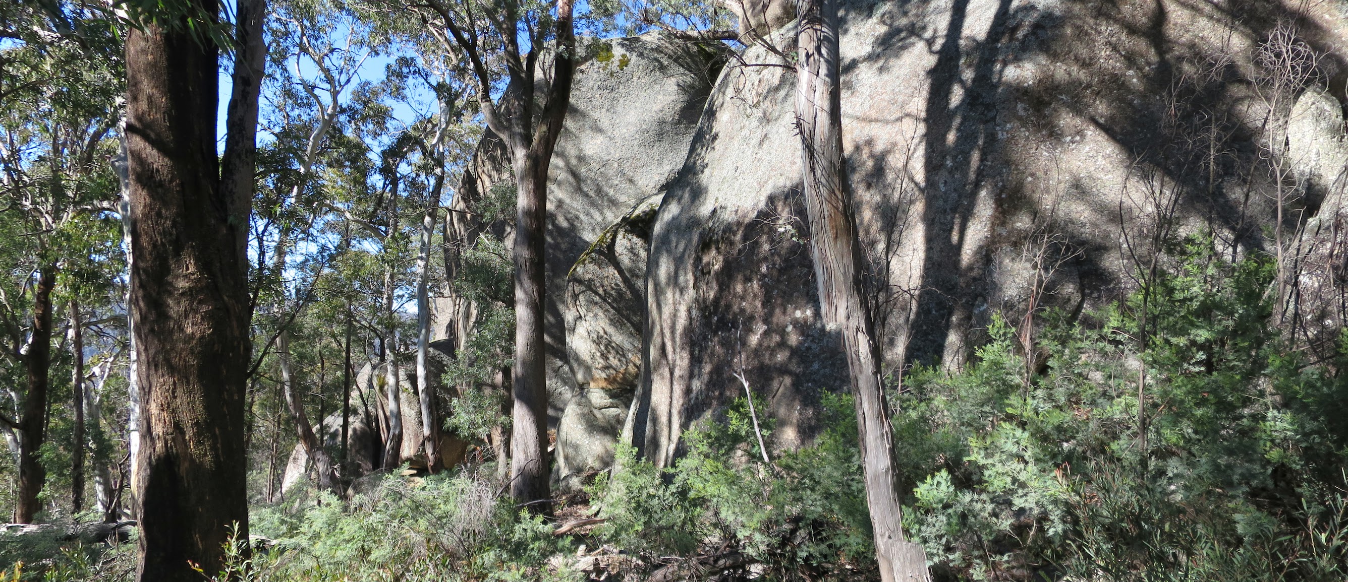
‘Big Boy’ granite on ‘Wretched Ridge’
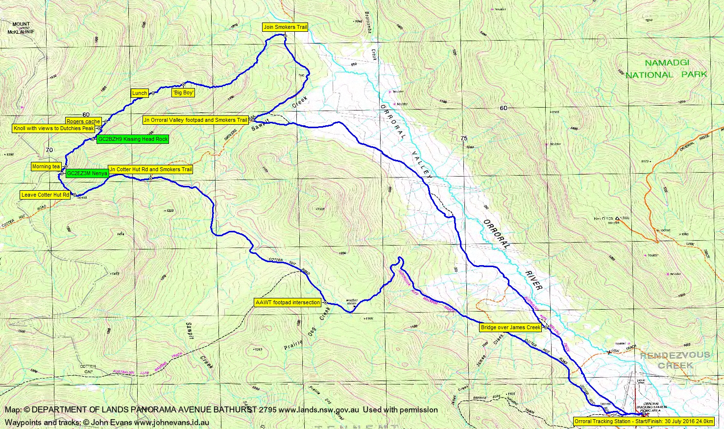
Saturday 30 July: Geocaches above the Cotter Hut Road – L/E&R,ptX. From the Orroral Tracking Station insert 10km along the Cotter Hut Road. Off-track for 2km and climb 200 vertical metres for geocaches GC2EZ3M Nenya and GC2BZH9 Kissing Head Rock. Return via Smokers Trail and the Orroral Valley. Around 20km and 500m climb. A walk suitable for those wanting an easy insert and exit, with a short introduction to the Namadgi bush. Maximum altitude 1300m. Maps: Corin Dam and Rendezvous Creek. Leader: John Evans, john@johnevans.id.au 0417436877. Please book by 12noon Friday. Transport: ∼$12. Limit: 8.
4 of us met at my old folks home and drove to the Orroral Tracking Station site car park.
Further Information
Marmaduke Rothschild’s geocache hidden on today’s walk has since been published. It’s GC6PCDQ Wretched Ridge.
Summary
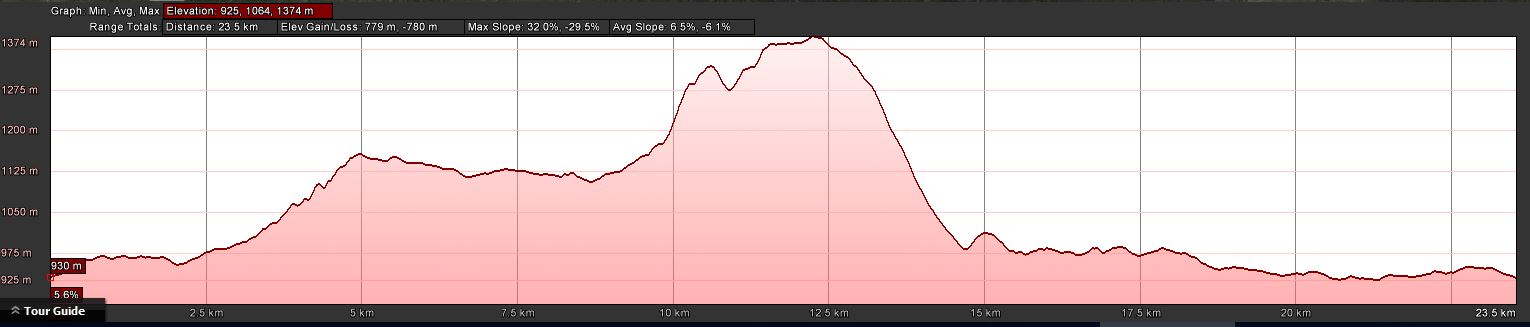
Distance: 24.0km | Climb: 780m | Time: 7.40am – 4.25pm (8hrs 45mins), including 35 mins of breaks | Grading: L/E&R,ptX; H(14)
Photographs
Photographs are available, where you can start a large sized slideshow.
Videos
Waypoint and Track Files
Download the .gpx file. (Right click, Save Link As…, Save – if you want to use it.)
To use in Google Earth, do File, Open… and select Gps or All files as the File Type.
Track Notes
We met at 7am in Gordon and were walking by 7.40am. The fog lifted as we left town and by the time we were cresting Fitzs Hill we had a blue sky day. Two wedge-tailed eagles having breakfast on the side of the road – they are big birds.
A frosty start in the Orroral Valley. 2 hours for the 10km to the gate on Cotter Hut Rd where we went bush.
What followed was the widest band of road-side shrubs I’ve ever had the displeasure of pushing through – it extended to the cache! It took 36 minutes to travel the 500m and 110m climb. The going was thick on the south-east facing slope and there were a few patches of snow. But we made a quick find of geocache GC2EZ3M Nenya.
More slow and hard going as we climbed another 30m then contoured along the 1300m line to morning tea. This little leg took 20 minutes for 200m. Views to the distant Tinderry Range as we had a 15min break.
The next leg took us to the north-east to the next cache, dipping down to cross a drainage line then up to find and log the geocache GC2BZH9 Kissing Head Rock. A dramatic granite feature. Difficult going, but a bit quicker, the 650m taking 32 minutes.
With the party willing to push on (and Roger with a beaut cache to hide further on), the plan was to get up out of the shade and snow to the crest of the ridge, in the hope that the going would be easier. So a further 60m climb over 400m taking 33 minutes to find the sun on a knoll which gave us great views to ‘Dutchies Peak’. A fine little cave presented a perfect location to hide Roger’s cache – luckily we checked the straight line distance from the previous cache to this location and it was only 180m (must be at least 200m from another cache). So on we went.
The going was not much easier on the crest and we named the area ‘Wretched Ridge’. Roger found a place to hide his cache and we pressed on through the shrubby going and snow patches, climbing a little to the high point of the walk at 1360+m. At last a lunch spot presented itself. The leg from the knoll with a view to lunch was 1km taking 56 minutes.
‘Wretched Ridge’ didn’t improve much after lunch; starting to go down made it a little easier. But a massive, massive series of granite blocks possibly made the leg worthwhile. We dubbed it ‘Big Boy’ and it’s just off the 1300m contour at GR 55H FA 71645-60421 (MGA94). Check out the videos and pics.
A small change from the plan of the place where we came out onto Smokers Trail, so that the other cachers could grab a cache there. From lunch to Smokers Trail was 2.2km in 1hr 15mins.
All over bar the shouting, except for the exit. 9km in 2hrs. Lovely views up to the Ridge of Stone and the various granite climbing features on it as we walked down the Orroral Valley.
Thanks boys! We’ll never have to go back up there again as, as I understand the caching rules, I can log Roger’s new cache once it has been moderated and listed and a FTF has been recorded (so hurry up Tank Engine or mtbikeroz).
Track Maps
Track overview
Track 1

Track 2

Profile
Party
4 walkers – Mike B (human muggle), Roger E (Marmaduke Rothschild), Llewellyn S (BlackLotusEater), me (JohnnyBoyACT).