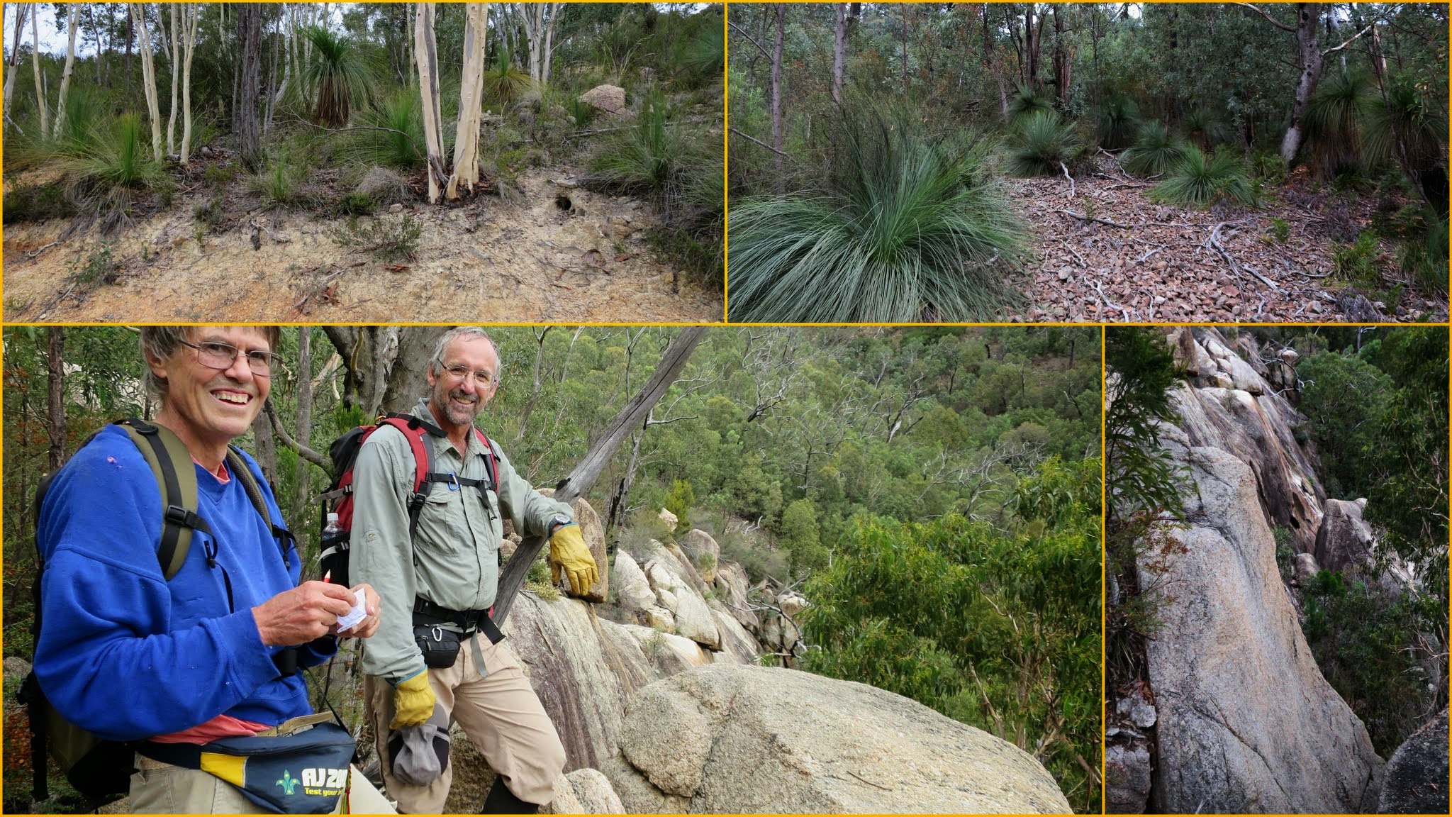
Plenty of Grass Trees | Sidling across scree to GC5CHVG Pierces Plummet | Happy buddies at GC5CHVG Pierces Plummet | A good drop below GC5CHVG Pierces Plummet
Saturday 4 April: Pierces Creek Falls – S/E-R. A short morning walk to Pierces Creek Falls and then on to the northern end of the Tidbinbilla Range for views. Mostly on fire trail however there is about 700 metres (distance) of scrub up and down a steep 100 metre (height) slope with loose rocks to the waterfall. I propose to look for two geocaches (GC5CHVA GC5CHVG ) on the way. There is also third geocache if anyone wants to visit it at the northern most end of the range. Distance about 7-8 kilometres. Leader Roger E. Limit 8. Transport about $4.00.
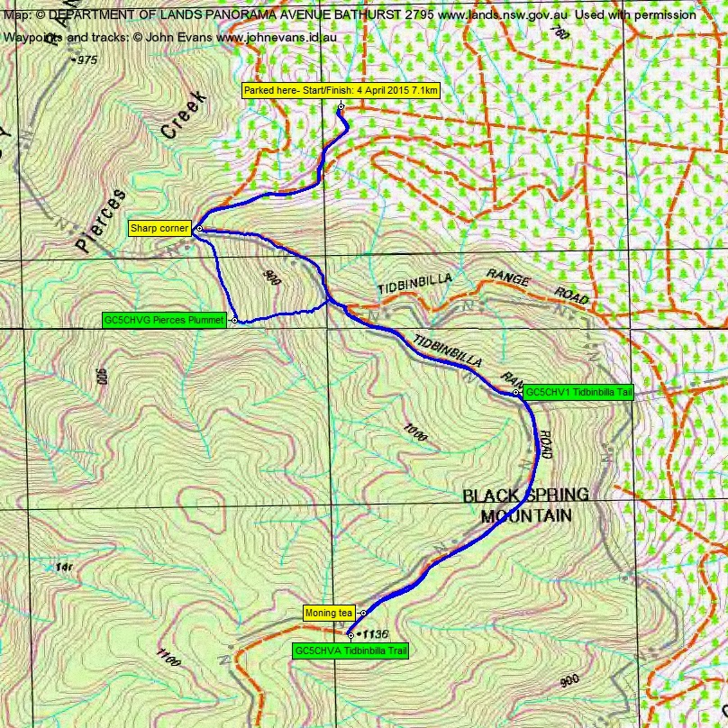
3 of us met and drove via Laurel Camp Rd in the old Pierces Creek Pine Forest area then west to near Tidbinbilla Range Rd.
Further Information
Pierces Creek Falls this certainly isn’t. Maps were Cotter Dam and Tidbinbilla.
Summary
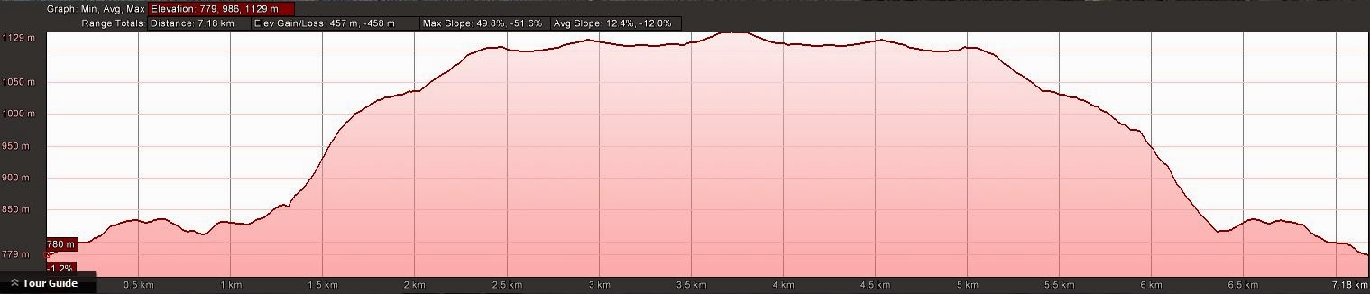
Distance: 7.1km | Climb: 460m | Time: 8.40am-11.30am (2hrs 50mins), with 7 mins of breaks | Grading: S/E-R; M(9)
Track Map
Track
Profile
Photographs
Photographs are available, where you can start a large sized slideshow.
gpx File
Download the .gpx file here. (Right click, Save Link As…, Save – if you want to use it.)
kml File
Download the .kml file here.
Track Notes
So good to get a walking endorphin rush (even if it was a gentle one). My dear wife is not too flash and it’s been a fortnight since the last walk.
Break up the word ASSUME and you get something along the lines of it makes an ASS out of U and ME. Note to self – never assume where a walk leader plans to park and insert. Sorry Roger 😳 .
A little wrong road on the way in the Pierces Creek Pine Forest area, but a win for me. Logged GC4DHFB Tulip 3 – Mineshaft.
So instead of descending to GC5CHVG Pierces Plummet from the sharp corner of the Tidbinbilla Range Rd (Roger’s plan), we climbed to the nose of the Tidbinbilla Range from my assumed sharp corner and sidled to the cache. But some very nice scrub with grass trees, scree and sharp Bursaria. Marmaduke Rothschild made a quick find and we admired the drop below. The log showed that the only previous cachers to visit here came at 4am in the morning to get the FTF. Brave in this country and coming to this drop. We climbed 200 vertical metres up to the Tidbinbilla Range Rd through a little easier going.
A stroll in a southerly direction along the Tidbinbilla Range Rd. Recently control burnt for several metres in on the east side. A quick find of GC5CHV1 Tidbinbilla Tail in the vicinity of Black Spring Mountain.
Some fire fighting equipment on the side of the road.
The hint for GC5CHVA Tidbinbilla Trail said ‘Fence Post’ and it was on the east side of the road. So I wondered what condition it would be in after the burn. It did look fairly forlorn and stood out like the proverbial, but it was in good nick.
Morning tea just after we about turned, on the west side of the road out of the grime.
Back where we emerged from the bush from our climb up from the first cache, we descended a very steep old fire trail. I’d come up it on 4 Aug 04. Back to the car.
Roger kindly stopped several times on the way out for me to find and log GC4DHHC Tulip 8 – Mineshaft, GC4DHFZ Blackfellow’s Road – Mineshaft, GC4DHH8 MRC 3 – Mineshaft, GC4DHFX Tulip 7 – Mineshaft and GC4DHGZ Tulip 5 – Mineshaft. This last one was right by the side of Laurel Camp Rd and its contents scattered about. I put it back together again but all I could add was a pencil. It needs a new log book.
Thanks guys, nice to get out even if only for half a day. A chance to try my new camera, a bit better than my old iPhone 4S.
Party
3 walkers – Mike B, Roger E (leader), me.