View west from the first knoll north of Tinderry Twin Peak over Michelago

Tuesday 4 August: Tinderry Range – L/R/X. From the Burra Rd we follow the West Keewong and other trails east for 6 km before heading off-track for most of the day. Ascend
to spot height 1325m (GR 057 528) and follow the crest of the Tinderry Range south for 4 km, passing over a couple of large knolls to the saddle 500 metres north of Tinderry Twin Peak,
which we won’t visit on this trip. We then head northwest, off-track for 8 km, following a series of steep spurs back to the start. This is a long walk with some thick scrub and rock
scrambling. Minimum distance: 20 km with approx. 950 metres of ascent. Maps: Tinderry, Michelago, Williamsdale. Leader: Ian W.
Transport: 112 km return. Limit: 8.
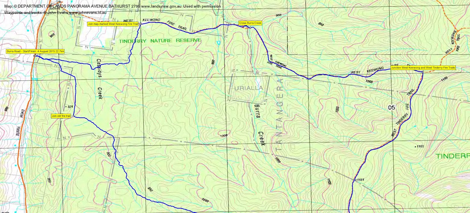
7 of us drove in 2 vehicles via the Monaro Highway, Williamsdale Rd and Burra Rd to park at an entrance to the Tinderry Nature Reserve.
Summary
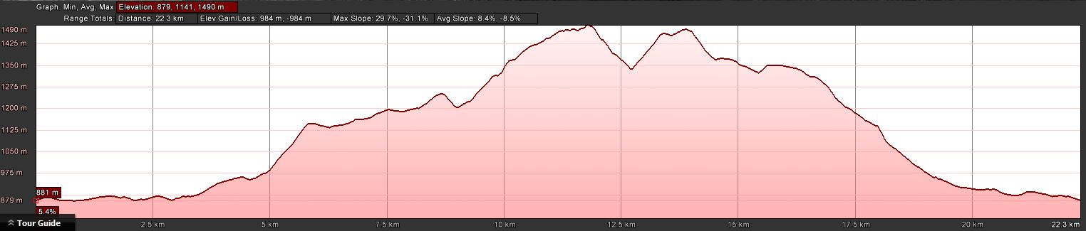
Distance: 22.7km | Climb: 980m | Time: 7.40am-4.55pm (9hrs 15mins), including 55 mins of breaks | Grading: L/R; VH(15)
Track Maps
Track overview

Track 1
Track 2
Track 3
Profile
Photographs
Photographs are available, where you can start a large sized slide show.
Video
Waypoint and Track Files
Download the .gpx file. (Right click, Save Link As…, Save – if you want to use it.)
Download the .kml file.
Track Notes
The temperature was at -4ºC as we drove out through the frost. With a maximum of 9ºC in Canberra for the day, it was a bit cooler at 1450m on the Tinderry Range. But a beautiful blue-sky
day and just perfect for walking.
The first leg was a climb up the West Keewong Fire Trail, the last 700m rising 140m from the 1000m contour. A heart starter. 5.9km in 1hr 20mins.
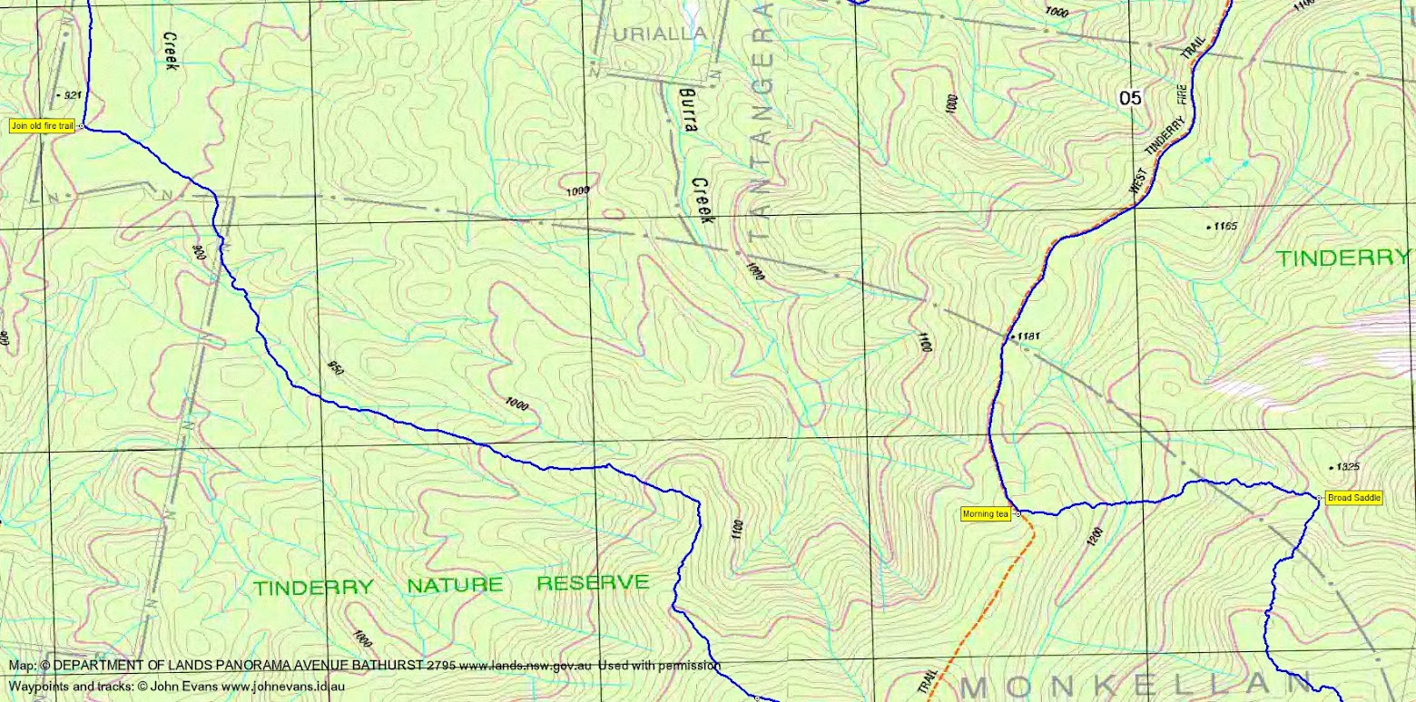
Then 2.8km in 40mins along the West Tinderry Fire Trail to morning tea.
From here we went off-track to complete the climb to the crest of the Tinderry Range. As with most of the crest, woodland canopy but with a awful lot of windfall timber and massive areas of
wild pig rooting. 1.3km in 40mins.
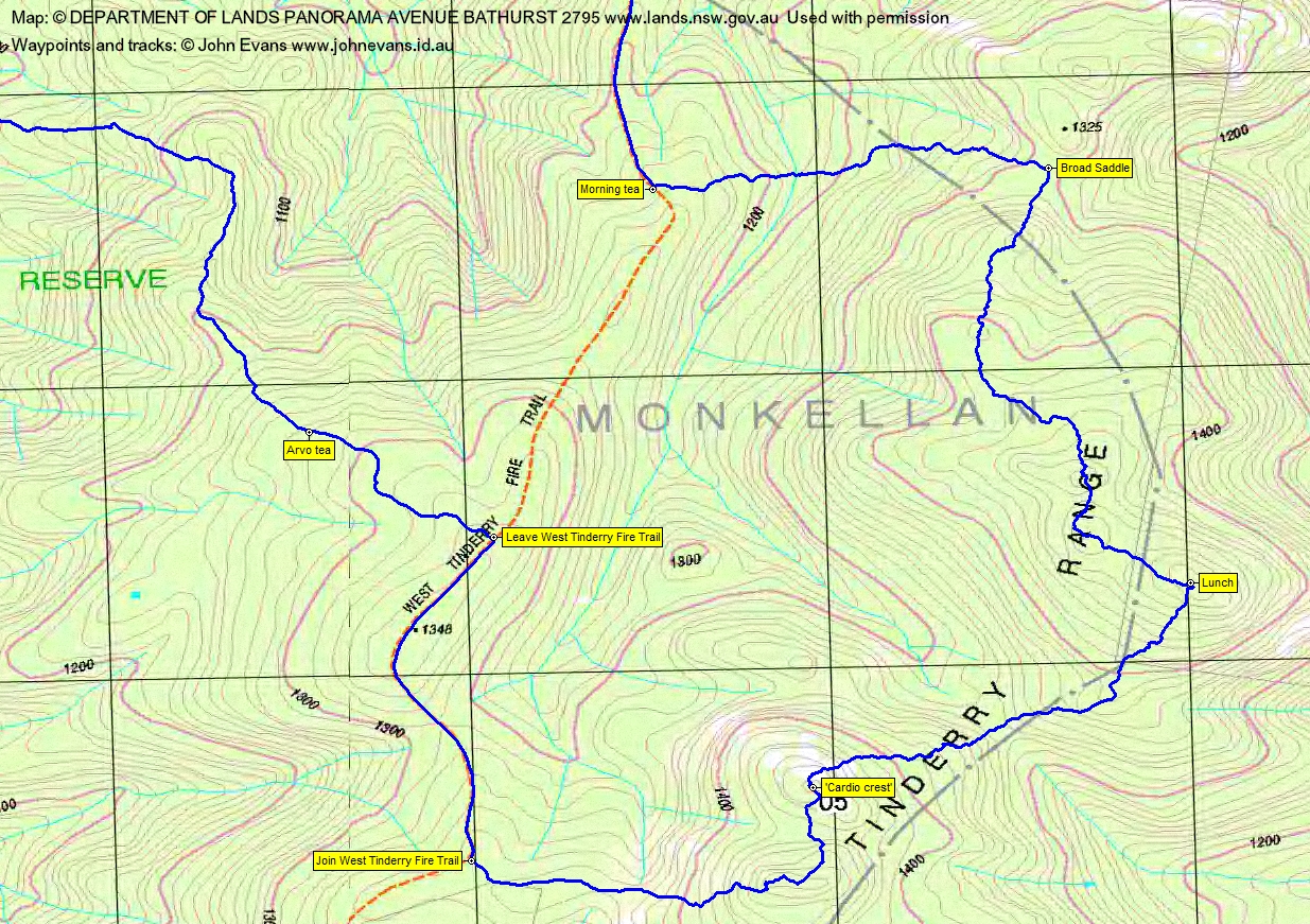
The next leg took us south along the crest. A bit more climbing and a series of rocky knolls to negotiate. From the broad saddle to lunch was 2.0km in 1hr 20mins. Slow going for a long
walk.
We could see Tinderry Twin Peak and Tinderry Peak in the distance from lunch, with a lesser knoll to the north of the Twin that we were heading for. So our track took us to the south-west,
down to a saddle, then up to a knoll which Ian said was unnamed. Today we called it ‘cardio crest’. 1.6km in 1hr 10mins. Great views to the west! We could see Googong Dam to the north.
Another knoll to the south also provided great views before we began our descent from the Range. Great views to Tinderry Twin Peak. We descended to the West Tinderry Fire Trail. This leg
1.5km in 50mins.
1.3km in 17mins on the West Tinderry Fire Trail.
A very pleasant (if you didn’t have a sore knee) descent from here, the gradient reducing and the going easing. 6.3km in 2hrs 10mins, including arvo tea.
A hard walk with a high grading. Thanks Ian.
Party
7 walkers – Mark B, Eric G, Meredith H, Stewart J, Jonathan M, Ian W (leader), me.
Next Tuesday Walk
Tuesday 11 August: An interesting cave site on the southern approach to Mt Herlt – M/R/X. On a previous walk we came across a cave that is worth another visit. The approach
is via the Rendezvous Creek grasslands and up a wooded spur on to the ridge that leads to Mt Herlt. The exit will be exploratory – out via Middle Creek. The walk will just scrape into M for
length but will be rough and scrubby on the spurs up and down. About 400m climb, about 13km distance. Map: Rendezvous Creek. Leader: Jenny H.
Transport: $40 per vehicle.