… or grumpy old man picks further holes in Cbr100Challenge route
Track Check out Black Mountain
Thursday 5 March: Cbr100Challenge Training – Check out Black Mountain – S/E. An opportunity to check out the 100km course of the Cbr100Challenge around Black Mountain.
Parked at the electricity sub station in Frith St.
Summary
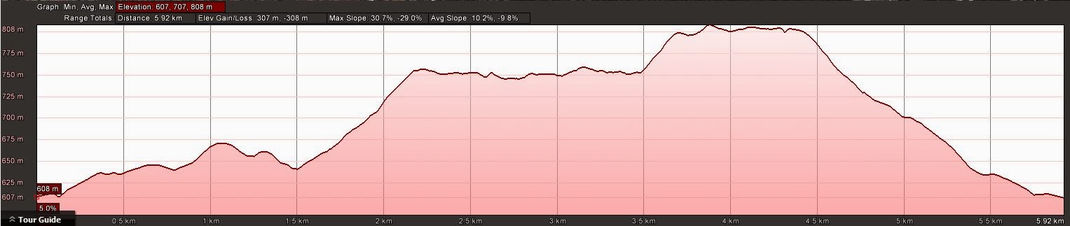
Distance: 5.9km | Climb: 310m | Time: 10.20am-11.25pm (1hr 5mins) | Grading: S/E; E(6)
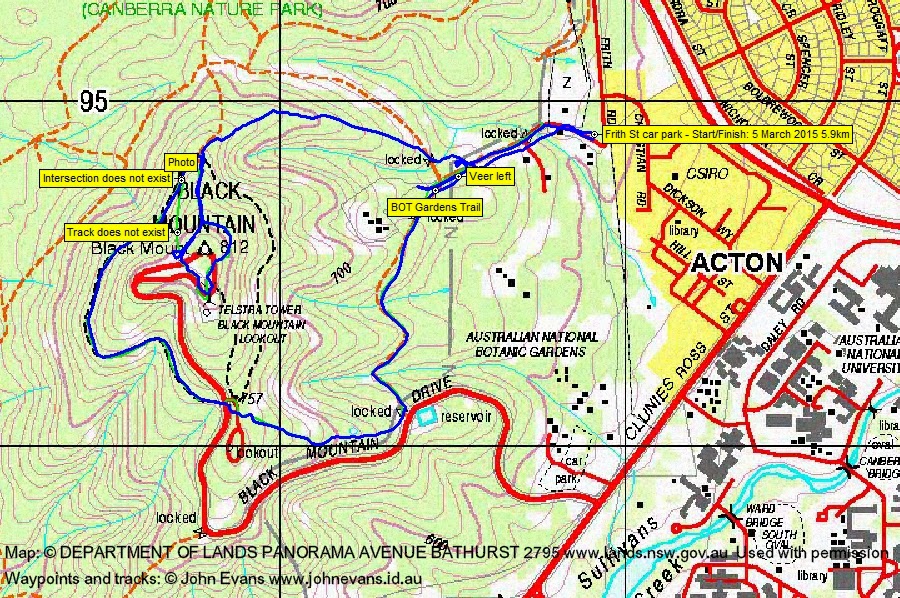
Track Map
Track
Green – current Cbr100Challenge 100km course alignment
Blue – me today
Profile
Photographs
Photographs are available, where you can start a large sized slideshow.
gpx File
Download the .gpx file here. (Right click, Save Link As…, Save – if you want to use it.)
kml File
Download the .kml file here.
Track Notes
An opportunity to check out the Black Mountain area (after a recent course change) for the Cbr100Challenge 100km route. Dropped Gay at U3A and parked in Frith St behind CSIRO.
I got excited as I drove up the road – lots of pink tapes about. Surely the course isn’t being marked 2+ weeks out. Correct – marked for Capital Punishment MTB Enduro.
Headed up the road and got the first junction correct – not up the concreted Black Mountain Tower track. A bit of faffing around around till I got it right – finally via an insignificant path onto the BOT Gardens Trail, which runs around outside the top perimeter of the National Botanic Gardens. I’ve never been on this trail before.
It generally contours to within sight of Black Mountain Drive, then climbs steeply from near the reservoir. This will be a doozy at around 3am on Sunday morning after 65km or so.
Through the lower car park and across Black Mountain Drive to join the ‘hat band’ track going clockwise around the west flank of the hill. Met a couple of guys with big packs training for Tasmania.
As I found a few weeks ago, the Cbr100Challenge intersection with this track does not exist (supposed to come down to here via a non-existing track). A photo via ContextCam (which superimposes geotagging data – a great app for a few $). Continued on 20 or so metres to the main intersection, turned sharp right and headed up the concrete path.
At the next intersection, headed left onto a flanking track that I’d never been on before. A Telstra work cage and sign on the track in view of Telstra Tower. Up to the main area at the top, following the Cbr100Challenge route.
More faffing about to exit Black Mountain. A new exit point to me and down a minor track, but well off the Cbr100Challenge course, So about turn, back up and a bit of a look around. There is no footpad or track on their alignment (green in the track map). In fact, for tired walkers in dark conditions, this would be dangerous. Will obviously be fixed, I hope.
So back down the minor track which soon joined the CCT alignment, down to the north and turned down the Black Mountain Track concrete path back to the car.
Party
1 walker – me.