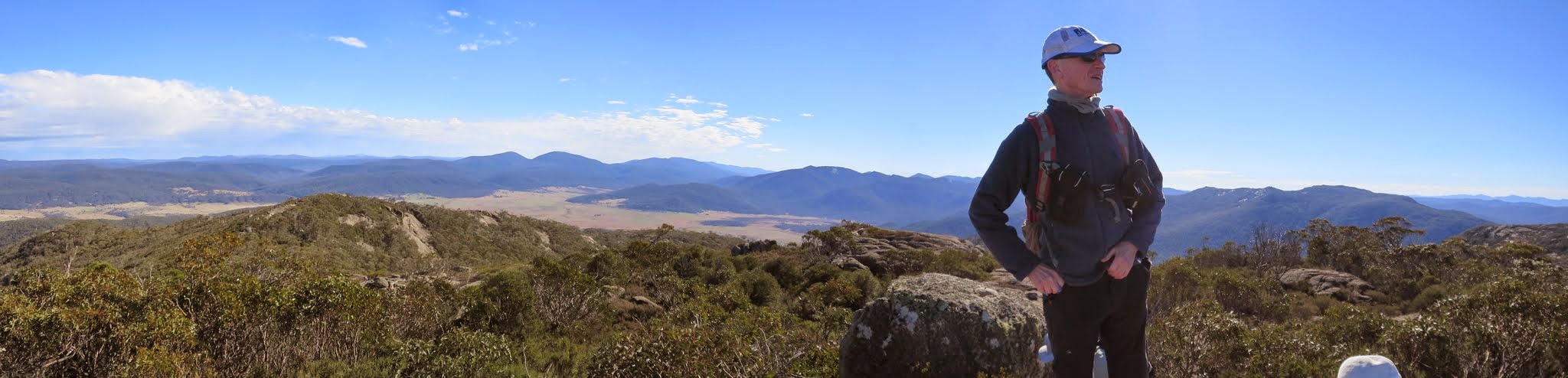
Ian on Yaouk Peak framing Mt Scabby and Sentry Box Mountain
Tuesday 5 May: Yaouk Peak – L/R,ptX. A long drive through the south of the ACT to a private property on Yaouk Rd. Farm track and footpad most of the way to Yaouk Peak. Descend 600m off-track via the northern spur. Around 14km and 700m climb. Map: Yaouk. Leader: John Evans 0417 436 877 john@johnevans.id.au . Transport: ∼$25 per person.
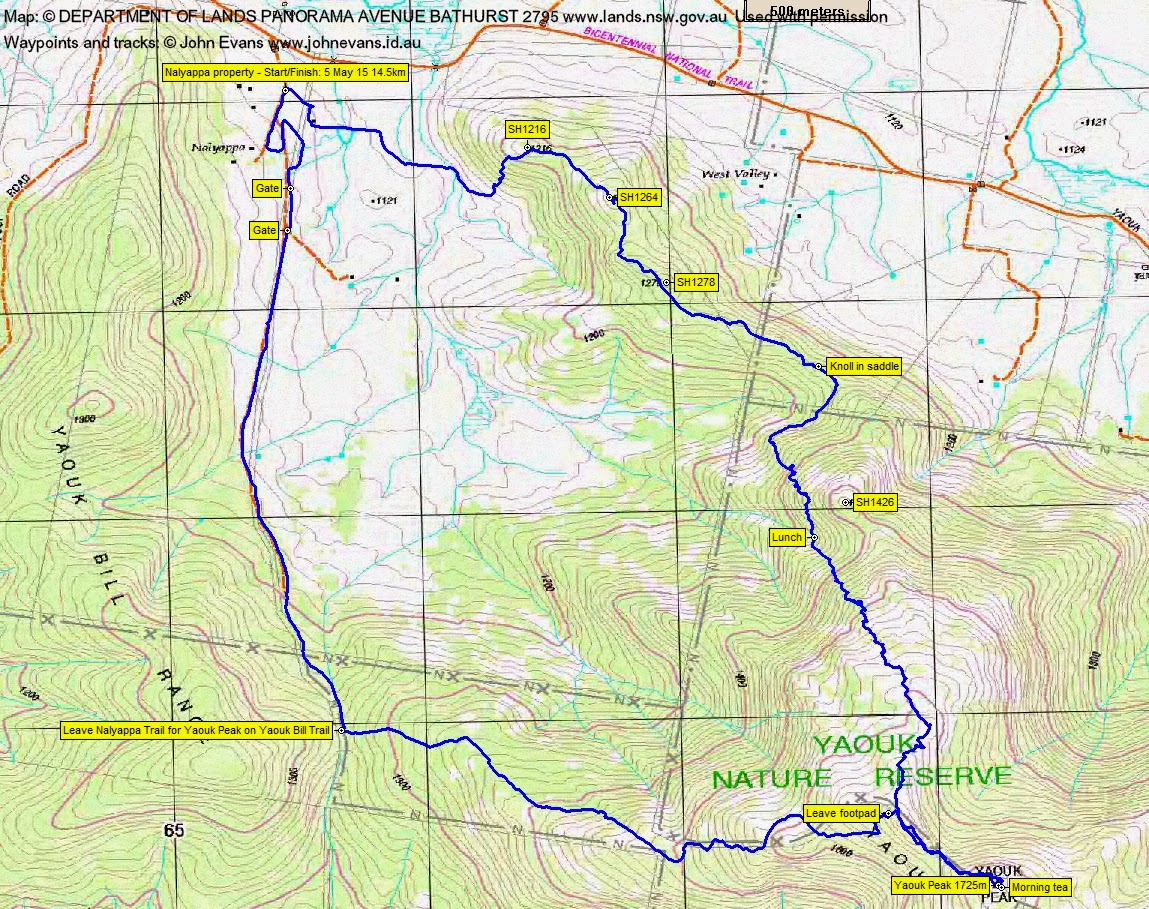
8 of us drove in 2 cars via the Boboyan Rd and Yaouk Rd to ‘Nalyappa’.
Further Information
‘Nalyappa’ is a private property and you need to gain permission from the owner to walk through to the Yaouk Nature Reserve.
Summary
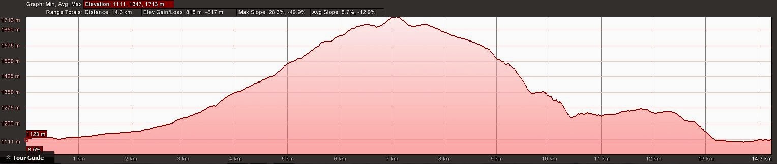
Distance: 14.5km | Climb: 820m | Time: 8.10am-3.00pm (6hrs 50mins), with 50 mins of breaks | Grading: L/R,ptX; H(13)
Track Maps
Track overview
Track 1
Track 2
Profile
Photographs
Photographs are available, where you can start a large sized slide show.
Video
Mute the sound – there’s nothing but the wind
gpx File
Download the .gpx file here. (Right click, Save Link As…, Save – if you want to use it.)
kml File
Download the .kml file here.
Track Notes
88km each way from Kambah shops to ‘Nalyappa’. No wildlife or cars damaged. About a 1 hour 30 minute drive. (A little further for Paul, who had driven down from Sydney the previous evening and drove back after the walk. Now that’s a keen party member!)
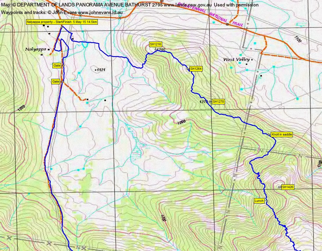
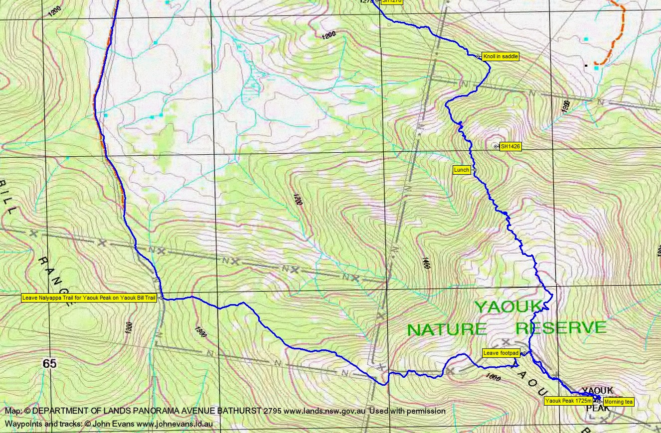
We began with a lap of the farm house area – until I got my bearings right. Then the long road south along the farm track, which becomes Yaouk Trail at the entrance to the Nature Reserve. After another 400m we came to the Yaouk Bill Trail sign and turned east to climb the spur towards Yaouk Peak on this Trail/track/footpad. A couple of photos of its varying states.
At a waypoint I had from my previous visit on 11 Jun 05, we pushed through a bit of scrub and gained some granite slabs which led us to the top rock pile of Yaouk Peak. 7.2km and 2 hours 10 minutes for the trip in, a little quicker than I’d expected.
The wind was howling! At one stage I was knocked over into Cynthia. The video is a little shaky in places as I held on. Mute the sound – there’s nothing but the wind. Nice views all round, which I didn’t see on the previous visit. The old trig vane was inscribed “… First gentlemen to reach this site 18/5/1939 AD”. I wonder who the previous visitors in 1931 and 1932 were, and the trig builders?
Fabulous views all round, especially to the ACT hills to the north – Scabby, Sentry Box and Gudgenby – over Bradleys Creek.
We retreated out of the wind for morning tea. Showers coming in from the west made a rainbow.
Our return leg was no more distance, but took a lot more effort and time. We first returned to near where we left the Yaouk Bill Trail, then generally followed the NNW spur.
Relatively open going at first, down granite slabs with bits of scrub between. But at around 1500m the going got a bit rougher. The last slab gave us a view of what was to come and my plan to follow the crest through SH1426 was changed to a sidle around its western flank. A little drop soon after required us to toss packs down before we could negotiate it.
Lunch was taken at 12.20pm, 2.7km and 1hr 35mins into the descent. This was a point where we could either cut and run for home via an easier descent to the NW to the open flats, or continue our rounding of SH1426 and regain the crest of the spur. The latter was chosen and we set off again after a very generous 25min lunch.
Some more steep and scrubby going to get back up to the crest at, yes, a knoll in a saddle. From there, easier and more open going through SH1278, SH1264 and SH1216. A final steep and scrubby little descent to the flats where a convenient tree got us across the creek.
Grazing paddocks and farm track back to the cars. From lunch was 4.7km in 2hrs 10mins.
Great views, a nice round, hopefully enjoyed by all. We were fortunate with the weather.
Party
8 walkers – Cynthia B, Eric G, Jenny H, Paul M, Max S, Chris R, Ian W, me.
Next Tuesday Walk
Tuesday 12 May: Cookbundoon Nature Reserve – M/R/X. The reserve was gazetted in 2010 and is located 15 km northeast of Goulburn. It is an area of about 7 km x 1.5 km, with steep gullies and ridges of native forests and woodlands. The area is new to the leader and will be on fire trails and off-track. There is a 1 hour 30 minute drive each way. Minimum distance: 15km with 500 metres ascent. Maps: Towrang, Chatsbury 1:25,000. Leader: Ian W. Transport: 270 km return. Limit: 8.
Nature Reserve Statement of Management Intent here; Fire Management Strategy with map here.