Fitz Hill, Glendale drystone walls and Billy Range
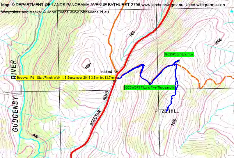
Saturday 5 September: Glendale Drystone Walls and the Billy Range– M/M-R,ptX. From the Brandy Flat Walking Track northern track-head, climb 300m to the north through a little scrub to visit the amazing drystone walls. Does anyone know why they were built? Find geocaches GC1W3E8 Getting Stoned and GC1W57N Passing Stones. Then north-east to climb onto the Billy Range. Return via a spur to Reedy Creek and so to the Brandy Flat fire trail. Around 12km and 750m climb. Map: Michelago. Leader: John Evans 0417 436 877 john@johnevans.id.au . Transport: ∼$12 per person. Late bookings welcome.
4 of us drove in 1 vehicle to pull off the road at the top of Fitzs Hill for the first walk, then to the Brandy Flat Walking Track car park for the second walk.
Further Information
A couple of geocaches and Fitzs Hill added.
Summary
Distance: 3.5 + 10.2 = 13.7km | Climb: 190 + 690 = 880m | Time: 8.05am-9.05am + 9.25am-3.10pm (6hrs 45mins), including 1hr of breaks | Grading: L/M-R,ptX; H(12)
Photographs
Photographs are available, where you can start a large sized slideshow.
Video
Waypoint and Track Files
Download the .gpx file. (Right click, Save Link As…, Save – if you want to use it.)
Download the .kml file.
Track Notes
Walk 1 – Fitz Hill
I’ve had these geocaches up my sleeve for a while, but always too tired to walk up to them on return visits from down south. So a stop on the way this time. I’ve spoken to one of the cache owners after first seeing them. I believe they are on private property; the cache owner said he had a map which showed public access up the fire trail when his cache was planted in 2010.
Anyway, we tromped up the fire trail. A stiff climb first thing in the morning. My eagle eyed companions retrieved GC3WDP3 Fitzy’s Five Thousandth and GC25P6Q Fitz’s Fun with no fuss.
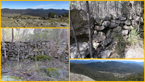
Since one may as well be hung for a sheep as for a lamb, we continued on up to the top of the rise of Fitzs Hill. Lovely views. Back down to the car.
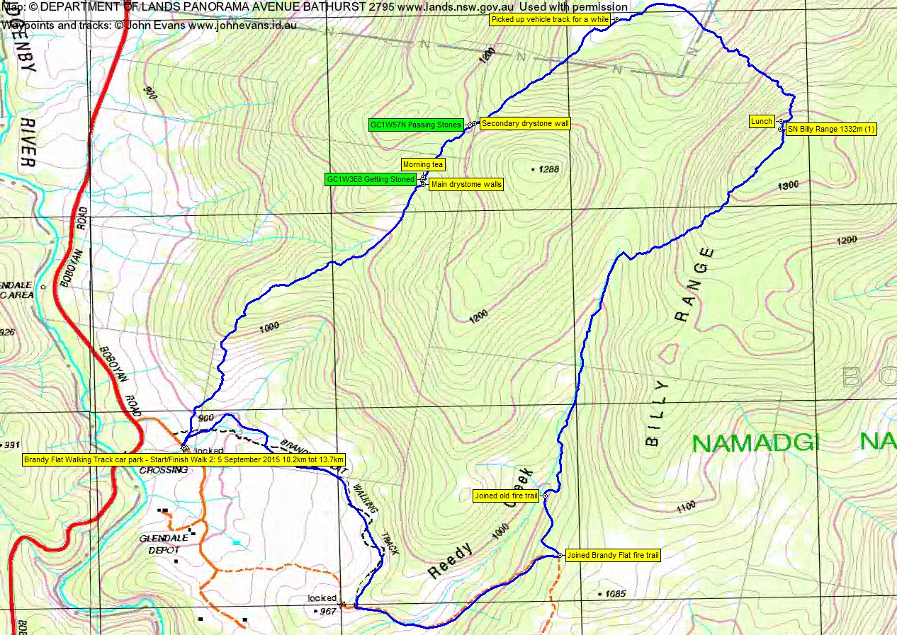
Walk 2 – Glendale drystone walls and the Billy Range
My third visit to the walls (others on 20 Nov 07 and 14 Nov 10), so you’d think I’d have the route correct. Better this time, following the walking track for a few tens of metres, then striking off-track up the crest of the spur. A lot of scrubby wattle and Cassinia, a couple of open patches. We broke out onto the open lead at around the 1090m contour which heads up to the main wall. I think I actually earned my keep and found GC1W3E8 Getting Stoned. Looking for the cache and morning tea led to visiting several more smaller sections of the walls. Some bits, up on the rocky knoll where we sat for morning tea, defy reason as to why they were built.
350m further up, we came to the second wall and cache GC1W57N Passing Stones, found by not me. Then a pleasant descent through more open going down the drainage line that forms Half Moon Creek. A little discussion as to how one does a half-moon – is it all trousers half way down or, somehow, half trousers all the way down? This brought us out onto a broadening cleared area, past a significant large boulder and, for a while, onto an old vehicle track.
At a convenient point we did a right turn, got ourselves back into NNP after a little trespass, and ascended 250m onto the Billy Range. A dry flank of the range, but plenty of Bursaria to rip at bare arms and legs. A bit of a puff, but not too bad. David tried to call in a wedge-tailed eagle soaring above us.
We curved up to the edge of the 1300+m flatish top of the Range here and found ourselves a bonus. A lovely granite slab with a huge view down to the open valley from which we’d climbed and up and beyond to the Namadgi hills and the Brindabella peaks on the horizon. A call home and a tweet.
David prowled and sighted during some of his lunch time, ensuring that we’d not get a 0.85 Billy Range Percy, but a full 1.0. He spied some boulders nearby, a little higher ASL, so we exited via them and scaled to the top.
The afternoon’s descent began by a wattle-scrubby leg along the 1300m feature, then downhill off the Billy Range to the top of Reedy Creek. More wattle and Bursaria, but a fraction softer on this more south facing side. Eventually out onto the cleared top of the Creek which I’d spied on Google Earth.
An uneventful hand railing down the creek, keeping up the side of the drainage line most of the time, especially round a little steep falling cascade area. At 1000m we came upon an old fire trail which climbed a little to join the Brandy Flat Fire Trail.
And so back to the car. Some lovely wattle in flower. The spot where the Brandy Flat Walking Track leaves the Brandy Flat Fire Trail always surprises me.
A beautiful blue sky spring day, with barely a breath of a breeze. So warm that I led my companions astray by stopping at the Tharwa General Store for refreshments on the way back. I must be a regular, as Val asked me where I’d been. I explained that the walking didn’t stop during winter; just that it was too cold to drink beer in that season.
Trust my companions enjoyed it. I did and the lunch spot was a real bonus.
Timings
| From | To | Distance | Time |
| Boboyan Rd | Fitzs Hill | 1.9km | 36mins |
| Fitzs Hill | Boboyan Rd | 1.7km | 24mins |
| BFWT car park | Morning tea | 2.0km | 55mins |
| Morning tea | Lunch | 2.6km | 1hr 35mins |
| Lunch | Join BFFT | 2.9km | 1hr 35mins |
| Join BFFT | BFWT car park | 2.7km | 38mins |
Track Maps
Track 1 – Fitz Hill
Track 2 – Glendale drystone walls and Billy Range
Party
4 walkers – Penny C, David D, Brett G, me.