View over Queanbeyan to Canberra from the Cuumbeun Nature Reserve

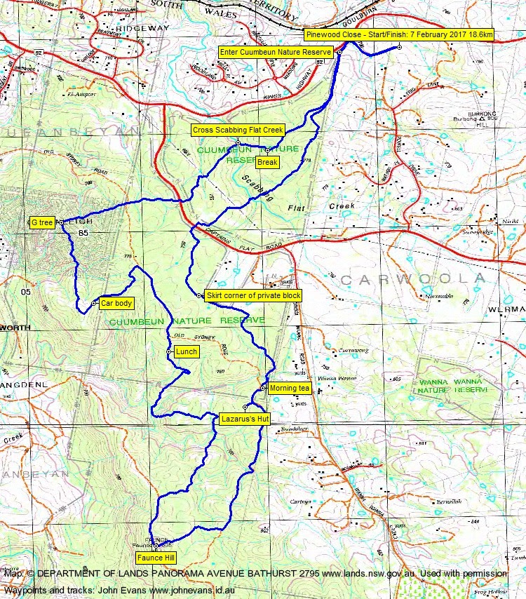
Tuesday 7 February: Cuumbeun Nature Reserve – L/M. A plan B instead of the Tinderrys, which could have been wet and slippery.
Further Information
I was last here with Ian on 1 Apr 14.
Summary
Distance: 18.6km | Climb: 640m | Time: 7.40am – 3.00pm (7hrs 20mins), including 60 mins of breaks | Grading: L/M; M(11)
Photographs
Photographs are available, where you can start a large sized slideshow.
Waypoint and Track Files
Download the .gpx file. (Right click, Save Link As…, Save – if you want to use it.)
To use in Google Earth, do File, Open… and select Gps or All files as the File Type.
Track Notes
Cuumbeun Nature Reserve brings out the Duke of York in Ian, and he led us up to the top of ridges and down across gullies many times.
Showers as we met on the Monaro Highway for plan A, the Gulwan area of the Tinderrys, so we headed out through Queanbeyan to Pinewood Close. Coats were required for the first 100m, then the weather just threatened all day.
We headed down Pinewood Close, around the corner and entered the Nature Reserve. Then SW to cross the Captains Flat Road and SE around the private block. Then generally S.
A visit to Lazarus’s Hut, its history revealed by Tim the Yowie Man.
Again generally S down the map-marked Old Sydney Road, now the Queanbeyan River Fire Trail. A short-cut to Faunce Hill and its trig, where I found an old geocache log. Now with reception all day I checked the geocaching app and at one stage I was within 28m of a cache. So a return trip will be scheduled!
Faunce Hill was the southern extent of the walk, so we turned for home. Not as easy as it sounds with Ian leading. More downs and ups through gullies exercised us as we returned to the north. And, just for fun, he added in an extra loop out to the west, first via a car body in the bush and then over the surveyed and map-marked Greenleigh area (similar to the surveyed and map-marked area at the junction of Gundaroo Rd and Duke Rd just over the ACT northern border). Good thing they didn’t develop Greenleigh – steep, poor rocky soil. We found a metal G hanging in a tree, marking the area?
Back across a few more fire trails (we crossed more than we walked along), back over the Captains Flat Rd, across the bucolic Scabbing Flat Creek (did the mulesed lambs recover there in the old days?) and so back to the cars.
Nice trip. Thanks Ian and all.
Track Maps


Party
6 walkers – Mark B, Melinda B, Eric G, Trevor L, Ian W (leader), me.
Next Tuesday Walk
Tuesday morning 14 February: Gigerline Trig – S/M. A walk in the Canberra Nature Park on the outskirts of Canberra’s southern suburbs. We follow the Murrumbidgee River south from Tharwa and then head east to the trig point before returning the same or similar way. Great views from top. About 100 metres from the trig is a large band of rock that has a geocache, GC22727 Gigerline Guardpost, located at it. Will be visiting this as well. Distance about 8 k with 300 metres of climbing. Map: Williamsdale. Home by lunchtime. Leader: Roger E. Transport: about $1.00, after meeting at Lanyon shops. Limit: 8.