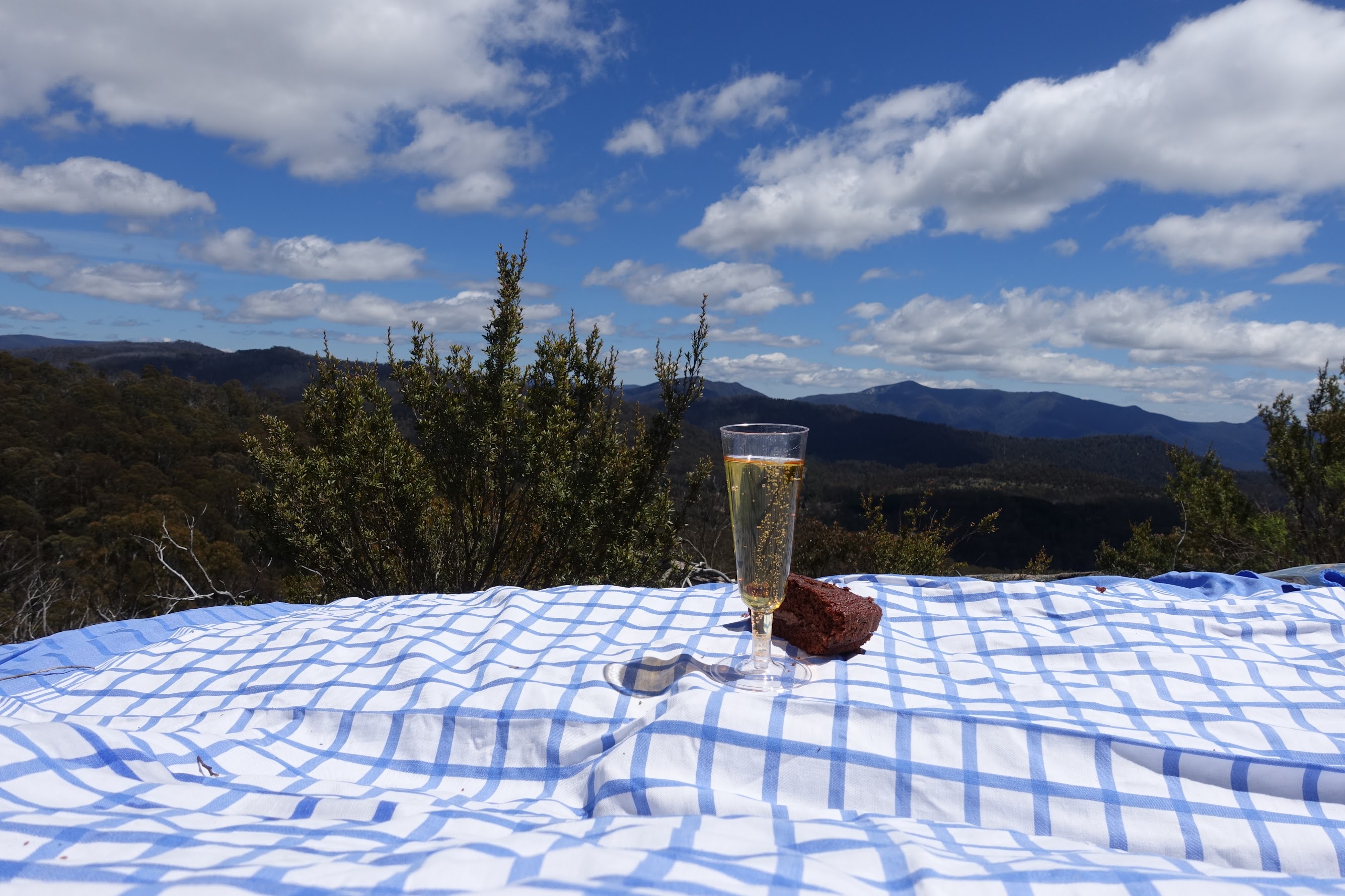
Chocolate cake and bubbles on White Horse Rocks
Tuesday 7 November: Punchbowl Creek and Blue Gum Creek – M/R/X. Follow the old track down Punchbowl Creek, view the falls, then climb up to White Horse Rocks and continue south to the saddle that leads down to Blue Gum Creek. Follow grassy open areas down the creek for a while then head west back to Smokers Trail. About 8.5km long and ∼450 m of climbing, probably some quite scrubby areas. Map: Corin Dam. Leader: Jenny H. Transport: $8 per person.
Further Information
A little different to advertised, basically reversed.
Summary
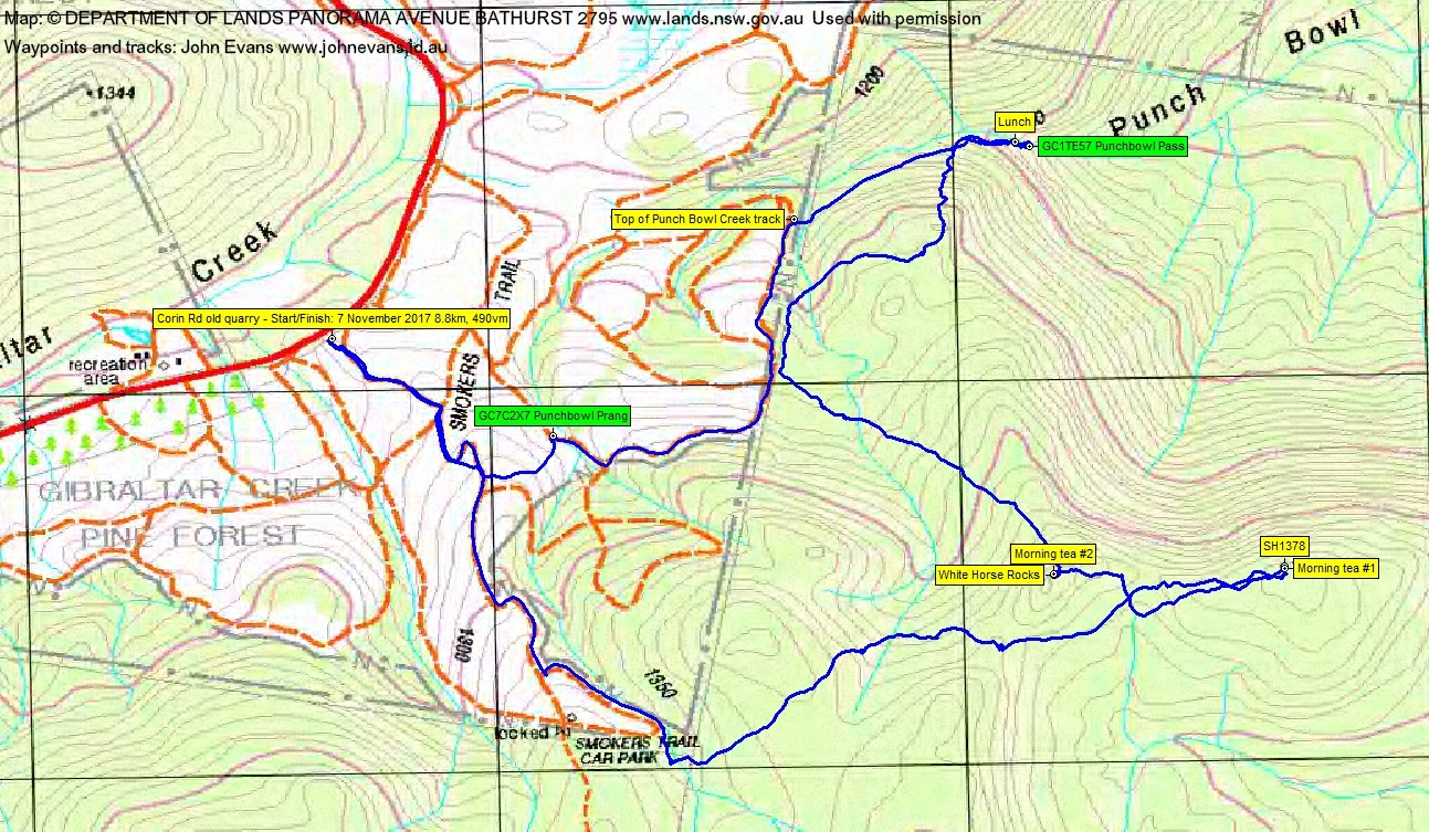
Distance: 8.8km | Climb: 490m | Time: 8.50am – 3.05pm (6hrs 15mins), including 75 mins of breaks | Grading: M/R; M(9)
Photographs
Photographs are available, where you can start a large sized slideshow.
Waypoint and Track Files
Download the .gpx file. (Right click, Save Link As…, Save – if you want to use it.)
To use in Google Earth, do File, Open… and select Gps or All files as the File Type.
Track Notes
I am indeed a blessed and fortunate old codger! Jenny organised a ramble fit for my advancing years and a great bunch of friends came along to enjoy this area of Namadgi National Park and celebrate my birthday.
We started on Corin Road at the old quarry area and wandered up a fire trail to join the management trail part of Smokers Trail. Up towards the old Smokers Trail car park we took a map-marked (now filled with logs and regrowth) fire trail, then struck off to the NE to head for SH1378. The initial slow going soon became more manageable and we wandered along through bitter pea regrowth in ‘bacon and eggs’ flower. On the higher slopes there were areas of tall-treed open forest.
We crossed a lovely open run between White Horse Rocks and SH1378, arriving at the latter for morning tea #1.
Next we walked generally west across the top of the drop down to Punch Bowl Creek and White Horse Flat to White Horse Rocks. Here we enjoyed a sumptuous birthday spread (on a table cloth, of course) of fresh, home baked chocolate cake, a little white wine and sparkling apple juice. Some very nice words were said. A place with grand views; not a mention was made of the Melbourne Cup.
Heading off with full tummies, we made our way down to Punch Bowl Creek. Those who hadn’t yet seen it were suitably dismayed by the bulldozed fire trail which has replaced the lovely footpad down the side of the creek. And it looks like the fire trail has not been ‘finished off’ and seems to be unusable.
My wonderful leader and companions even indulged in the dark art of geocaching, no doubt just to humour me. They crawled up and down the steep bank of the creek below the fire trail. Much to my embarrassment, no cache could be found. So we retreated upstream a few tens of metres and settled in by the gurgling creek for lunch.
Disappointed in my performance, I returned to the indicated cache location and, with Phillip’s help, found and logged GC1TE57 Punchbowl Pass. This was a highly valued prize, as on 8 Jun 17 I’d reported it gone and registered a DNF. Now that makes a birthday!
Again, on our homeward leg though the pine forest fire trails, my leader and companions were generous enough to detour via GC7C2X7 Punchbowl Prang for me to find and log.
A truly lovely and relaxed walk with great friends. Thank you Jenny and all.
The day was topped off with many social media messages and an email from friends, Skype calls with my children in Mexico and Sydney. My dear wife even gave me a 6-pack of (light) beer. Who could ask for more?
Track Map
Party
7 walkers – Chris F, Linda G, Jenny H (leader), John J, Max S, Phillip S, me.