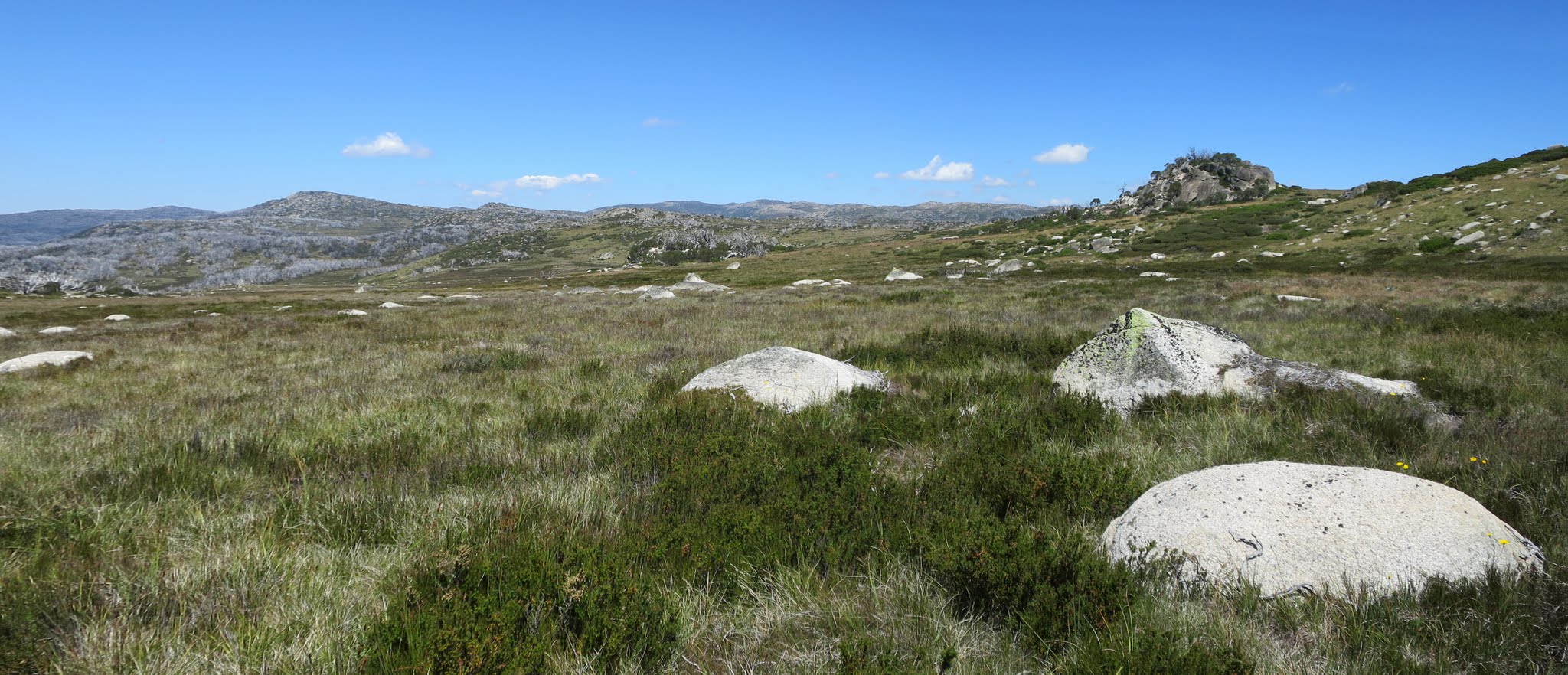
View south along the Great Dividing Range including Big Brassy Peak
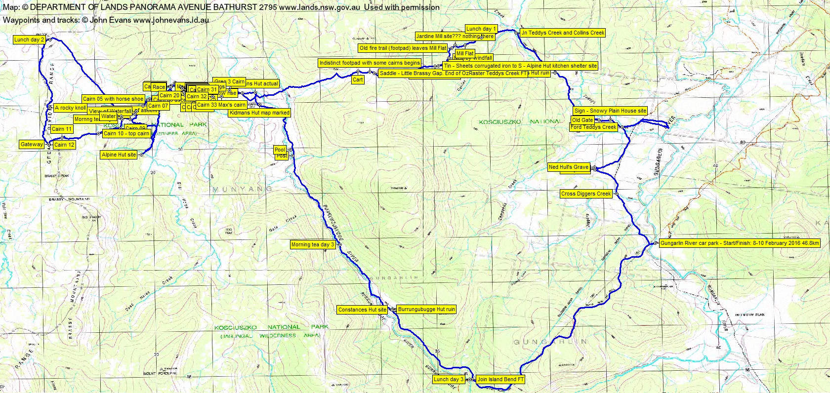
Monday 8 – Wednesday 10 February: Kidmans Hut, KNP wilderness – M/M,X. Weather dependent. Commence Gungarlin R, 12 km to Kidmans Hut where we will camp for 2 nights. Day 2 explore area below Main Range, hopefully find ruins of Alpine Hut. Day 3 Return to car via Burrungubugge Hut ruin and along Gungarlin R. (15 km 300 m, scrub, hard). This walk is mainly exploratory for leader. Maps: Nimmo Plain, Jagungal, Geehi Dam, Kalkite Mountain Leader: Max S for further details. Numbers limited.
6 of us drove in 2 SUVs via Nimmo Hill to the Gungarlin River Camping Area car park.
Further Information
Huge thanks to Max for organising this trip. Information from Robert Green (who has recently authored Exploring the Jagungal Wilderness – A bushwalker’s guide to Kosciuszko National Park, in hard-cover (ISBN 9780994451590) and e-book format (from Amazon)), and Greg Hutcho contributed greatly to the planning. One of Robert’s aims is to make this area of Kosciuszko National Park and the Jagungal Wilderness Area better known. I’m sure this trip and this presented information will contribute to that.
There is some detail on the Gungarlin River dredge, Snowy Plains House (Napthali’s), Kidmans Hut and Brassy Gap (derivation from ‘as cold as a brassy monkey’) on pp 118-122 of Huts of the High Country by Klaus Hueneke, ANU Press 1983 ISBN 0 08 034388 0.
Summary
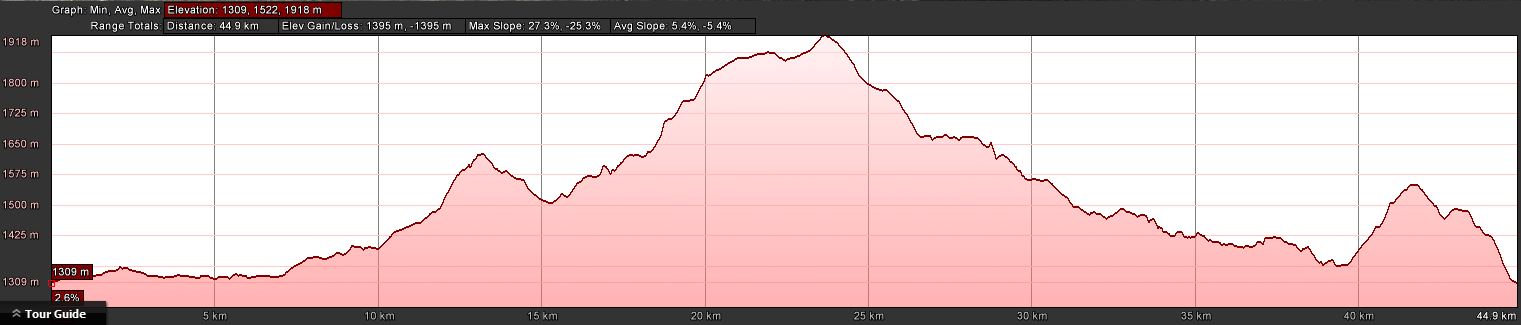
Distance: 46.8km | Climb: 1395m | Time: 3 days | Grading: L/R,X; H(12)
Photographs
Photographs are available, where you can start a large sized slideshow.
Videos
Waypoint and Track Files
Download the .gpx file. (Right click, Save Link As…, Save – if you want to use it.)
To use in Google Earth, do File, Open… and select Gps or All files as the File Type.
Track Notes
Day 1 – Gungarlin River to Kidmans Hut
This was a fabulous walk led by my best walking buddy Max S and accompanied by other great friends. It was a hard, exploratory walk. We enjoyed perfect weather in this wonderful place. In less than ideal weather (snow, cloud, etc), it would be an extremely challenging walk and you’d need to know what you were doing.
I was whisked from my very front door in leather-seated comfort, pushing out a few zeds. Left lower Canberra at around 7.15am and travelled via Cooma, Cooma airport, right into Rocky Plain Rd from Kosciuszko Rd, crossing Middlingbank Rd, left off the sealed road into Nimmo Rd, and a pretty rough ride to the Island Bend Fire Trail near Nimmo Hill. Finally a very rough Island Bend Fire Trail following the power line to the Gungarlin River Camping Area car park. Around 2hrs 45mins.
Kitting up, we met another party from northern NSW setting off for a week out. Friends of friends in Canberra – small world.
Away just after 10am NW up a very gently sloping beautifully green open valley to Daveys Hut. Caught up with the other party. Had a quick poke about (a lovely hut) and a look at the nearby Ned Hull’s grave.
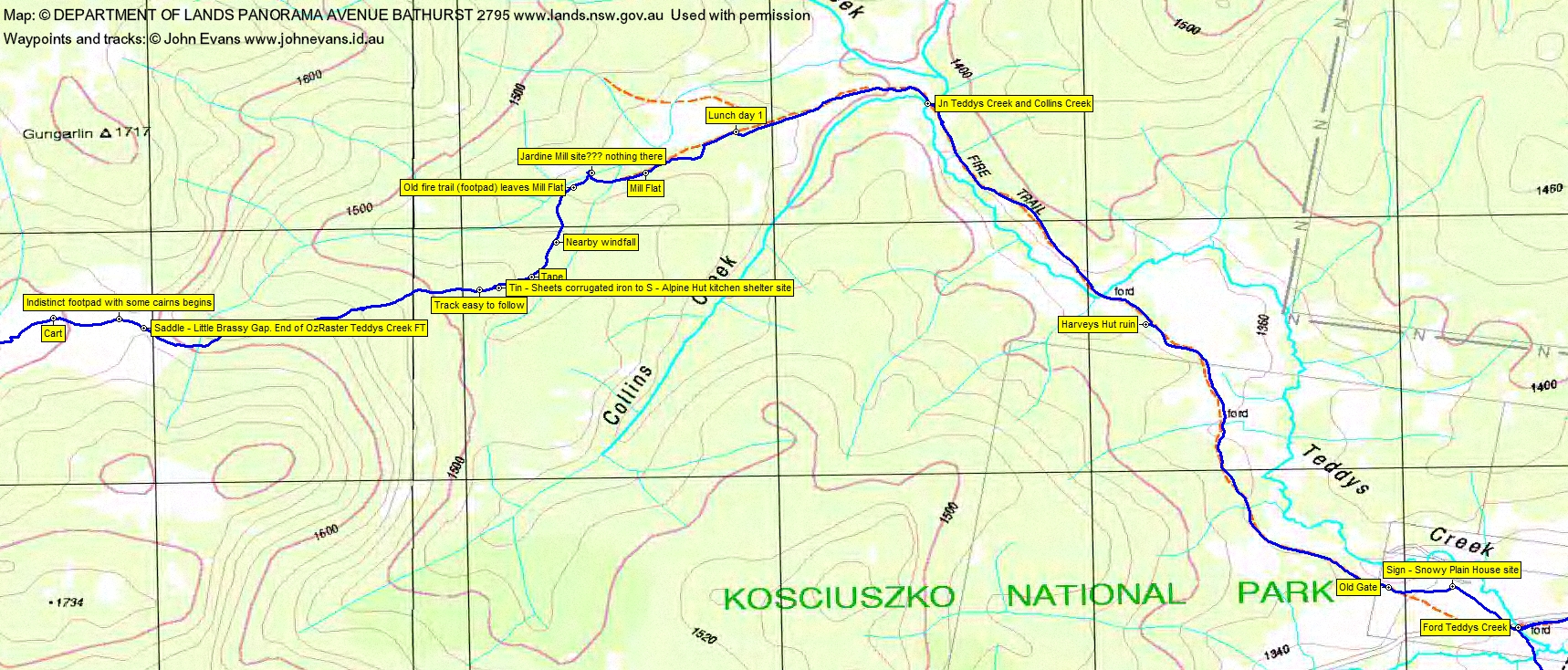
Crossing Teddys Creek, we took a faint fire trail to the NE, then branched off east and headed to the KNP boundary. Here Eric took a photo of a distant feature, zoomed in on it and identified it as the dredge site that Max was looking for. You can see that our track on the map segment went no further, as the dredge was on private property, but a couple of us had an even better telephoto lens and it was as if the site had been visited.
Back to pick up our packs, we wandered up a hill to the Snowy Plains House site. A great location.
An old gate (one of Greg’s helpful waypoints) was passed as we continued along the pretty Teddys Creek fire trail. We called in at the Harveys Hut ruin. We turned SW at the junction of Teddys Creek and Collins Creek, by this time complaining bitterly that no morning tea had been called. At 12.50pm our leader relented and we found shade from the sun, It was certainly warm and the slip, slop, slap was in vogue.
Our route continued on through Mill Flat, where we had a look for the Jardine mill site, but could find nothing. A few tapes on the track as we left the Flat. We viewed the Alpine Hut kitchen shelter site (read Robert’s book for more information!). Another nice section of rising track took us to Little Brassy Gap.
From here it was all down hill, with Kidmans Hut soon in view across a feeder and the Back Burrungubugge Creek. A broken down cart with, was it the skeletons of the beasts of burden that pulled it?, lay on the route.
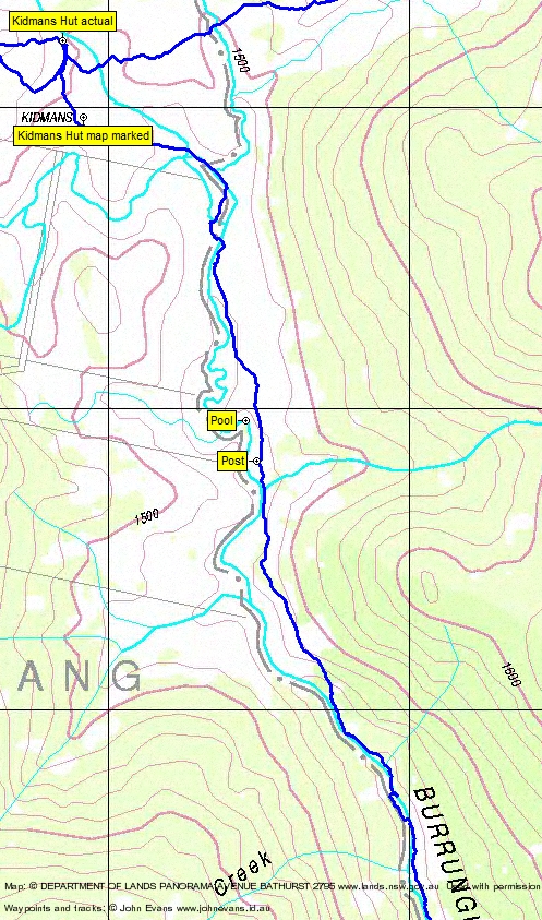
Into Kidmans at 3pm. The surrounds a bit slopey and pig rooted. The first two of us to arrive found reasonable sites, but the other four had to camp a little further away. The other party of 5 arrived some time later and camped down near the creek. A few ants.
Some canvas and aluminium stools in the hut aided the comfort of sitting around outside. We all cooked on gas and didn’t light a fire.
My usual drill – to bed on that wonderful Exped mat and a couple of hours of music. A mild night and the tent door open (not the mesh). The stars, with no moon or town lights, were magnificent.
Day 2 – Kidmans to Mailbox Hill, return via Alpine Hut site
A relaxed breakfast as the sun came down into the valley. Another perfect day.
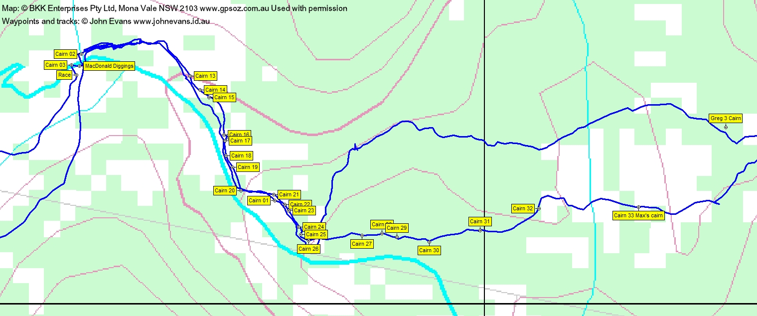
Away at 8am with day requirements in packs. We tried to follow open leads to the SW then NW, but there was a little scrubby going to get us to the bottom of the Burrungubugge gorge (don’t think Shoalhaven-like!). We dipped our toes in the river, then tried the bank and eventually picked up the cairned route to the top of the gorge where it opens out onto a plain. Picked up a couple of cairns indicating where the route crosses the Burrungubugge River and identified MacDonald Diggings and possibly the race.
Although the open lead rising to the saddle in the south (and so up to Big Brassy Peak) looked inviting to me, Max knew where we should be heading. The next leg took us SW across the lead, then up a scrubby at times ascent. Again, some known cairn locations in my GPSr, thanks to Robert and Greg. A nice view to the upper Burrungubugge River falls as it tumbles down from a higher plain.
At last out onto it and, because there had been much banter, morning tea was called. Water from the nearby river.
Nearly south down the lead, then W-ish up over a gentle rise. Passing the known cairn 10 we saw wild horses to the SW under Brassy Peak. Now these beasts (be they wild horses or brumbies) can divide a nation and also a family. I know one such couple where one loves the animals and the other rates them second only to pigs or the damage they cause. Where do you stand? Aerial shooting by professionals or let the hunters at them? Anyway, they galloped closer and looked in good nick with shiny coats. They cut close across our path, then were gone.
At 11.20am we reached the crest of the Great Dividing Range at a know location of a gate. Posts on the ground, but with tied off wire, identified the site. Huge views on this wonderful day!
Decision time and, although I hoped for south to the Brassys, it was north to Mailbox Hill. Just as good! I don’t know much of KNP, but had heard of Mailbox Hill and Cup and Saucer and the Bulls Peaks. Have visited Jagungal. So this trip put the area in context for me somewhat.
Lovely walking along the crest. Open going, but not easy, traversing wet patches and the ever-present pig rooting. Mailbox Hill provided enormous views, lunch and home and social media contact. One wouldn’t be dead for quids!
A 2km leg to the SE though open going took us to the water point near morning tea, then another 1km descent through some scrubby going to the next open plain (the saddle area we’d seen from MacDonald Diggings). A little west of south in the hot afternoon some saw us across the top of Dead Horse Creek and at the Alpine Hut site. Objective achieved! A poke about, with Max relating the hut’s history and usage.
We retraced our steps to the saddle and continued along a brumby trail for a while, heading east of north back to the race and diggings.
A quicker descent of the Burrungubugge gorge. I decided to waypoint most of the cairns, so the map segment is a bit fussing and I have tens of photos of little rocks on big rocks. We came out of the gorge a bit lower and back to Kidmans first lower, then a terrible higher route (because I was leading).
A repeat of the previous night, except it was Teriyaki Beef instead of Honey Soy Chicken. The starry sky took my breath away again (thank goodness, that meant I didn’t snore). A second night without having to get up with old man’s syndrome.
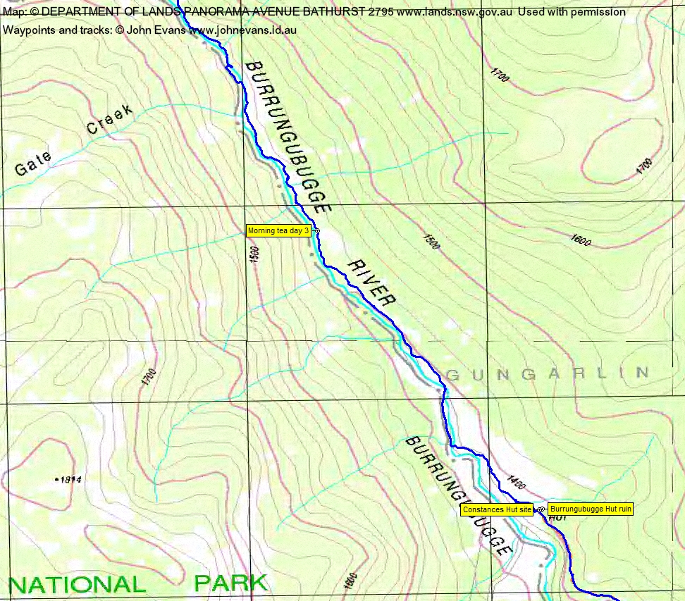
Day 3 – Exit via the Burrungubugge River and Island Bend Fire Trail
Broke camp and away by 8am. Although direct, this was not an easy day. The Burrungubugge River at first provided open going, but there were then high, scrubby spurs to cross. We crossed the river several times, looking for the easiest going. Mike did a great job with a lot of the leading. We were thankful for the wombat pads. It was pretty, but the day was hot. Morning tea was taken in some meagre shade. A lone, maybe limping, horse on the other side. No fisherman’s footpad materialised as we neared the hut sites.
Max had taken me to Constances Hut site and Burrungubugge Hut ruin on 26 Nov 13, so this was another ah hah moment as I put the area together.
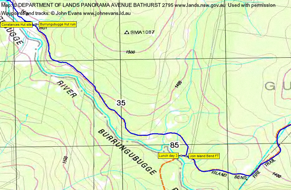
The old vehicle track is in name only for all but the last bit. Very overgrown and only the benching beneath the waist to head high regrowth distinguishes it. Lunch on the side of the Island Bend Fire Trail.
There were options to visit the Botherum Plain Hut on the way out, but after we slowly toiled up the fire trail to the west of SMA0104 in the heat, we’d had enough.
Not one for water (it’s for drinking, isn’t it?), even I enjoyed a brief swim and a wash in the Gungarlin River and a change of clothes.
Spotted the dog tree on the way out, just near where we came back on to the sealed road.
A wonderful trip to Kidmans Hut and an ascent to the crest of the Great Dividing Range. Huge thanks Max and co.
Track Maps
Track overview
Track 1

Track 2
Track 3

Track 4

Track 5
Track 6
Track 7
Track 8
Track 9

Profile
Party
6 walkers – Mike B, Eric D, Stephen M, Max S (leader), Phillip S, me