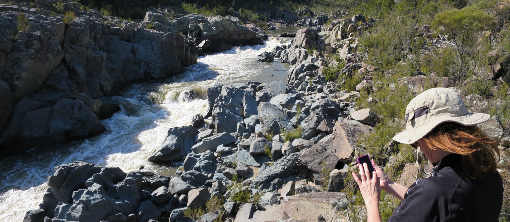
Murrumbidgee River churning
Saturday 8 August: Gigerline Geocaching – M/M,X. Some geocaching in the Gigerline Nature Reserve off Smiths Road. Walk along the banks of the Gudgenby and Murrumbidgee Rivers. Around 10km and 300m climb. Map: Williamsdale. Leader: John Evans 0417 436 877 john@johnevans.id.au . Transport: ∼$8 per person.
3 of us drove to park up the top of a dirt road directly over the Smiths Road Gudgenby River bridge.
Summary
Distance: 8.7km | Climb: 215m | Time: 8.40am-1.30pm (4hrs 50mins), including 50 mins of breaks and a few minutes of driving | Grading: S/M,X; M(8)
Photographs
Photographs are available, where you can start a large sized slideshow.
Videos
Waypoint and Track Files
Download the .gpx file. (Right click, Save Link As…, Save – if you want to use it.)
Download the .kml file.
Track Notes
Foggy as we walkers left home from three different suburbs, but the sun was shining at our Kambah meeting point.
We drove south through the suburbs, then Tharwa, and turned left onto Smiths Road with the Cuppacumbalong shearing shed on the corner. Angle Crossing closed, but we weren’t going that far.
In fact, we only drove a few hundred metres, parked on the side of the road, and Chifleygrrrl began a fine day of cache finding. GC52V1W Vamp Trail – Edward quickly found by Madam and logged.
We then drove across the bridge and straight on up the dirt road to park on the crest by the entrance to the Gigerline Nature Reserve.
A quick look for GC52V1R Vamp Trail – Dracula, but didn’t spend much time as the cache is currently marked off-line due to a few DNFs. We then walked along the ridge north towards the De Salis cemetery, across the other side of where the Gudgenby River flows into the Murrumbidgee River. Not particularly exciting, but I’d always wanted to view the site from this side.
On our return, we had another look for GC52V1R Vamp Trail – Dracula. It turned up easily, thanks to Alison’s eagle eyes!
A vehicle track headed south from the car, so we continued in that direction. A find and log of GC52V23 Vamp Trail – Nosferatu, then GC52V1F Vamp Trail – Lestat. From here the road veered left past the Tharwa Sandwash, Murrumbidgee River Corridor sign, and down to a picnic area. You can drive to here.
A benched old vehicle track continued further up-river and we went down to the bank towards GC1265B High and dry. The hint says “Highest point, driest sand!” and it may have been, but the water flowing swiftly in the river made it impossible to reach. So not a DNF (did not find) but a DNA (did not attempt!).
Continuing along the track Alison again quickly found GC533BM Vamp Trail – Stefan, then GC53EY7 Vamp Trail – Spike.
By now the path had deteriorated into a footpad. We crossed a gully, found GC53EXY Vamp Trail – Sam, Chifleygrrrl dropped off trackable CBHVWH Whiskers the Cat Travel Tag, and sat down to morning tea under a lovely Kurrajong with huge twisted root system. Views down to the river.
We set off up the hill along a fence line and found and logged GC5DNJZ Vamp Trail – Elizabeth and GC5DNKB Vamp Trail – Peter. No need to cross the fence, so I discovered.
From here I’d planned a route well up from the Murrumbidgee River and its cliffs to come around from the top of the last cache down this way. But we could see down along the river and a clear area along the side of the bank. As one does (or, at least, as I do) I chose a middle route – neither one nor the other. A little traversing along the steep side of the river and a look ahead to the tightly scrubbed hillside convinced me to zig and zag us down to the riverside.
Here, a very pleasant amble up-river along the sandy flats. Soon a few rocks appeared at the lower end of the river gorge. The side creek we had to cross was no issue. This is, indeed, a very pleasant area and more than made up for the initial uninteresting country. Some mild scrambling down by the river provided wonderful photos and videos of the swiftly flowing, noisy, river. The spoiler photo and hints led Chifleygrrrl to a find of GCH33C Murrumbidgee Meander II.
We all thought it would be a perfect little amble if the return could be all along the bank of the river. And this we were able to do, staying by the river bank where we had come down from above. We popped out where we’d had morning tea. Back to the picnic area where we had an early lunch.
We walked back to the car, then drove up Smiths Road to stop beside and find GC52V2E Vamp Trail – Angel.
Then drove back over the Gudgenby River bridge and walked up the side of that river to log GC53EYG Vamp Trail – Jure and GC53EYP Vamp Trail – Pam.
Back to the car and home by 2.15pm.
I’d not walked on this side of the Murrumbidgee in the Gigerline NR before. I’ve seen CBC walks of a few years ago enjoying swimming in the area in summer but, not being a swimmer, wouldn’t necessarily come here. The Murrumbidgee Meander II geocache is an example of why I enjoy a bit of caching – it brought me to an area I’d otherwise not visit.
Thanks for your company Alison and Bob. Trust the outing was of use to you too.
Track Map
Track

Party
3 walkers – Robert D, Alison N, me.
Next Saturday Walk
Saturday 15 August: Worn Boot Bash – L/M. This year the route is a circuit: Mt Clear camp ground to Long Flat – Mt Clear – Left Hand Creek – Horse Gully Hut – camp ground. Leaders: Jenny & Rob H.
Helen Turner
8 August , 2015 10:46 pmI’m really pleased you enjoyed my vamp trail. It might be time to put some more upstream. Great blog John.
Johnny Boy
8 August , 2015 11:10 pmHey Helen – thanks for making contact. We had a great time and it’s a lovely area once you get upstream a bit. Hope we saved you a trip out there re Dracula. Thank you for all the work you do in setting them up. Cheers. john