Clockwise from top left – Fungi | Tree fern gully SE of the cars | Scribbles in Tallaganda | Overlooking the Tallaganda forest to Mt Palerang | View west from the west-most point of Mt Minor | Lichen on pink granite at lunch | Mountain Blueberry (Elaeocarpus holopetalus) grove
Wednesday 8 June: A mount minor from the West Wednesday Walk series – M/R. A delightful circuit with three viewpoints, elegant granite and very varied vegetation. From the Jingle Money Fire Trail in Tallaganda NP, up the Serenity Rocks track for 1 km, then off–track for the rest of the day. Firstly, up steep ridges with mostly light scrub to rock slabs with a view. Across to a granite bluff where keen scramblers can take a vertical route while others take a steep but non-scrambling way round. East along a scrubby ridge with bonus lawyer vines, through a patch of sub-alpine rainforest and up through orange granite and ferns, and patches of scrub, to the more westerly of the Mounts Minor. Back through forest to the cars. 8 km, 400 metres ascent & descent, about 5 hours actual walking. An hour’s drive from Queanbeyan, best done with AWD/4WDs. No need to book, but Wed Walk participation rules (see elsewhere) apply. Meet at Spotlight carpark, 6 Bungendore Road, Queanbeyan, at 8.30 am. Map: Bombay. Leader: Linda G. Transport: $44 per car.
13 of us drove in 3 4WD/SUV to park on the side of the Jinglemoney Fire Trail.
Summary
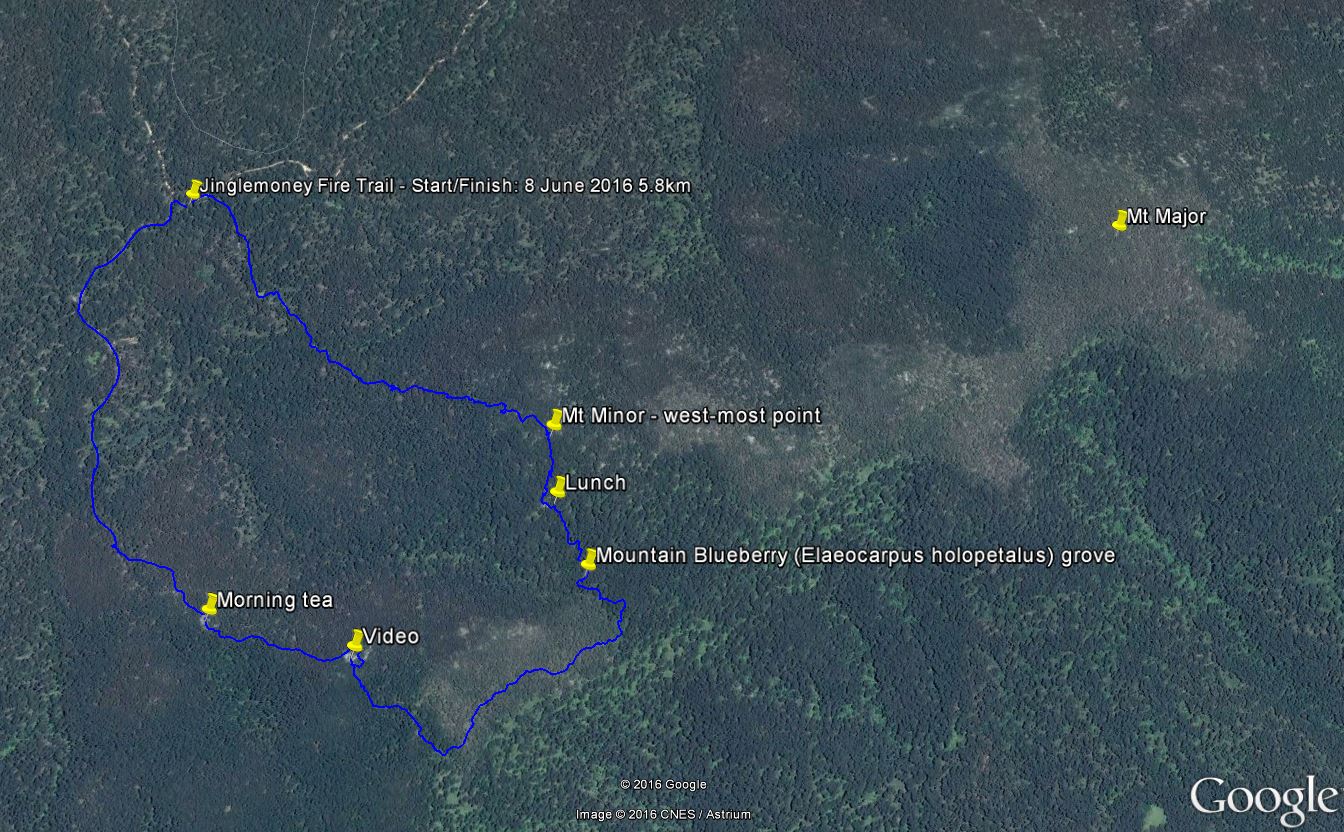
Distance: 5.8km | Climb: 360m | Time: 10.0am-3.00pm (5hrs), including 45 mins of breaks | Grading: S/R; M(9)
Photographs
Photographs are available, where you can start a large sized slideshow.
Some more photos on the CBC Facebook page.
Video
Waypoint and Track Files
Download the .gpx file. (Right click, Save Link As…, Save – if you want to use it.)
To use in Google Earth, do File, Open… and select Gps or All files as the File Type.
Track Notes
A portent of things to come with a short wait at the Molonglo River ford on Briar Sharrow Road as they cleared the debris from the water over the road. Hats off to our drivers for getting us there. They drove through a creek ford that I was happy to walk through to check the depth, but would not have been happy to drive in my old bus. The realignment of the Jinglemoney Fire Trail does not show on my 2006 and 2011 digital maps, so I included a Google Earth snip below.
A short, but beautiful and interesting walk. Pink granite (due to potassium feldspar, thanks David D), stands of Brown Barrel (Eucalyptus fastigata), paddocks of Mountain Pepper (Tasmannia lanceolata), Linda found a grove of Mountain Blueberry/black olive berry/mountain quandong (Elaeocarpus holopetalus) (thanks for the identification Isobel), some temperate rain forest and lovely views.
A cool day for the round, but no rain. A bit windy. The going was a little slippery due to recent precipitation. One small leech bothered to search me out, but was quickly given the flick. I got down ∼2m instead of getting up after lunch. Walked out ok, but have a curry-giving left knee now.
An excellent trip, as always, thanks Linda and all.
Track Map
Track

Track from Google Earth
Party
13 walkers – Peter C, Isobel C, David D, Eric G, Linda G (leader), Jenny H, Barry K, Trevor L, Steve R, Terrylea R, Barrie R, David W, me.