Bungongo State Forest

Tuesday 9 June: Bungongo State Forest – L/R,X. Bungongo State Forest is located between Wee Jasper and Jugiong. This is a new area for the leader. This is a long exploratory walk, in native forests and woodlands, with numerous ascents and descents. The walk starts near the western end of the forest and is mainly off-track in the catchments of Parsons and Old Jeremiah Creeks. There is a 2 hour 15 minute drive each way. Minimum distance: 18 km with 900 metres of ascent Maps: Adjungbilly, Wee Jasper. Leader: Ian W. Transport: 400 km return Limit: 8.
4 of us drove a long way via Yass and the Hume Highway. At Pettit we turned east on the Gobarralong Rd, crossing the Murrumbidgee River. Then onto the Gobarralong Adjungbilly Rd, north up the Nanangroe Rd and finally onto the good dirt of the Bungongo Rd to a convenient road side car park. Left Woden at 6.10am and arrived at 8.40am.
Summary
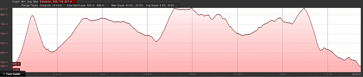
Distance: 19.5km | Climb: 925m | Time: 8.45am-4.00pm (7hrs 15mins), with 50 mins of breaks | Grading: L/R; H(13)
Track Maps
Track overview
Track 1


Track 2

Profile
Photographs
Photographs are available, where you can start a large sized slide show.
Video
Waypoint and Track Files
Download the .gpx file here. (Right click, Save Link As…, Save – if you want to use it.)
Download the .kml file here.
Track Notes
A 13 hour day, door to door. All sealed road, except for the last couple of km on good dirt.
A heart-starting start with a 290m climb to Parson trig. Then down and east, paralleling Parsons Creek. We continued east, picking up the occasional fire trail, to cross Old Jeremiah Creek and a little climb to lunch.
The clouds had been rolling in from the south and the drizzle began. Shells on, but not inconvenient, as it was quite cool too.
Beautiful open walking on the 800+m ridge as we turned SW.
Coming off it, we heard forest machinery. Picking up another fire trail we came upon the workers’ vehicles, then the machinery. The first was picking up pine logs with a grab claw and loading them onto a tray on the vehicle. A bit further on we came upon a harvester machine. Stopped, thank goodness, so the operator could see and hear us. A transformer-like big boy’s toy with a mean looking array of items on the hydraulic arm. A very nice guy, allowed us to take photos, then knocked down and processed a couple of trees as a demo for us. I was so fascinated, I only got the video going at the end.
Thanks to Ian W who found:
The large machine we looked at yesterday afternoon was a Valmet 6 wheeled harvester and it was made in Finland.
The smaller machine carrying the logs to the truck loading area is known as a Forwarder.
A harvester is a complex piece of equipment.
From Wikepedia:
• a chain saw to cut the tree at its base, and also cut it to length. The saw is hydraulically powered, rather than using the 2-stroke engine of a portable version. It has a more robust chain, and a higher power output than any saw that can be carried by a human.
• two or more curved delimbing knives which reach around the trunk to remove branches.
• two feed rollers to grasp the tree. The wheels pivot apart to allow the tree to be embraced by the harvester head, and pivot together to hug the tree tightly. The wheels are driven in rotation to force the cut tree stem through the delimbing knives.
• diameter sensors to calculate the volume of timber harvested in conjunction with a measuring wheel which measures the length of the stem as it is fed through the head.
Moving on, we came out of the pine plantation and across Old Jeremiah Creek again and arrived at the Gildarts Hut site. Not so impressive.
Half a km of fire trail, then a long leg off-track and generally to the NW (with two arvo tea break-lets!) to get us back to the start.
Well worth the long drive to have a look at this area. A few patches of casinia, but mostly open woodland walking with a few ups and downs. Some beautiful stands of timber in places. The misty/cloudy conditions added a little je ne sais quoi to the vistas.
Thanks Ian for another great one.
Party
4 walkers – Eric G, Ian H, Ian W (leader), me.
Next Tuesday Walk
Tuesday 16 June: Gudgenby Valley Wander – M/M. Using old and new knowledge, we’ll visit hut ruins, interesting stone arrangements, the Yankee Hat art site, some lovely hillocks and beautiful stream features. Might see a water rat too, plus an eagle’s nest from last season. About 13km, mostly off-track in grassland with some timber. Maps: Yaouk, Rendezvous Creek. Leader: Matthew Higgins. Bookings: John Evans 0417 436 877 john@johnevans.id.au . Transport: ∼$10.