I79 – twin lockspits | U79 cement cylinder | G80 | View down the headwaters of the Cotter River near Mt Scabby to Mt Kelly

Saturday 22 March: Border Markers from Yaouk Gap to Mt Scabby – L/R,X. Very early start and very late finish. A long drive to the S of the ACT then NW to Rowleys Hut. Walk up Yaouk Trail to Yaouk Gap, then SE along the ACT-NSW border on the crest of the Scabby Range searching for border markers. Lunch on Mt Scabby with later opportunity to view the source of the Cotter River. Steep and scrubby 600m descent. Around 14km and 700m climb. Maps: Rendezvous Creek and Yaouk. Limit: strictly 8 strong walkers. Leader: John Evans – john@johnevans.id.au, 0417 436 877. Transport: ~$35 per person. Further details at www.johnevans.id.au.
3 of us drove from Canberra via the Boboyan Rd to Shannons Flat, then Yaouk Rd and Kennedys Rd to park at the S end of Yaouk Trail and the track to Rowleys Hut. ~100km.
Further Information
Civil sunrise = 6.42am; Sunrise = 7.08am; Sunset = 7.13pm; Civil sunset = 7.38pm.
Around 2hrs 30mins drive each way. About 110km each way.
3km walk with 160m climb up Yaouk Trail to Yaouk Gap. 6km walk with 550m of climb along the border, going unknown, could be scrubby. A wander down to the source of the Cotter River. 4km plunge down the side back to the cars.
Met with Stephen and David from Team SES who did the entire border late last year. They said there is some open granite along the tops, but also some scrub SE of Yaouk Gap. I know the descent from Mt Scabby is difficult.
Look for geocaches GC22CDM SCABBY (regular size, in cubby cave ~30m E of summit in ACT, see phone for spoiler pic) and GC21C1A Source of the Cotter (regular size, cache located a metre or so below the top of the bulge, see phone for 2 spoiler pics). Maybe GCNV1H Gudgenby Gander (small) at the lookout on the way home if it’s light.
Summary
Distance: 14.9km | Climb: 750m | Time: 8.50am-4.40pm (7hrs 50mins), with 30 mins of breaks | Grading: L/R,ptX; H(13)
Track Maps
Track overview
Track 1
Track 2

Photos
Photographs are available, where you can start a large sized slide show.
Video
Google Earth
Download the Google Earth .kmz file here.
Track Notes
Left home 6.30am, then via Pearce (and a brief petrol fill) to Kennedys Rd at the intersection with the track to Rowleys Hut. The roos and wallabies were out in numbers. A couple of patches behind the gates on the upper parts of Kennedys Rd were pretty sloppy after rain. (I spent the rest of the morning worrying that we wouldn’t get out, as the clouds rolled in over Mt Morgan. As it turned out, the day got sunnier – no rain – and the sun and breeze dried the road out a bit. No worries coming home.) Parked around 8.45am, so a 2hr 15min trip from home.
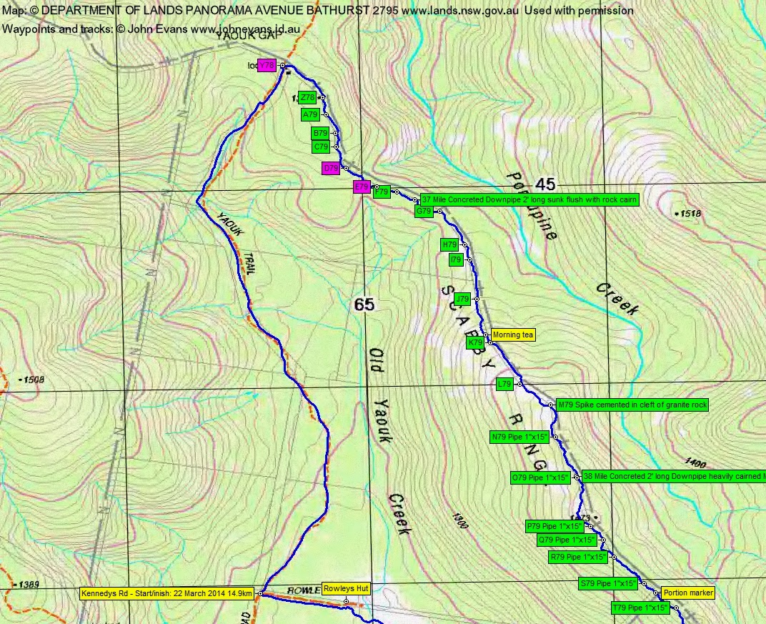
3.1km in 40mins to Yaouk Gap. No sign (again) of Y78.
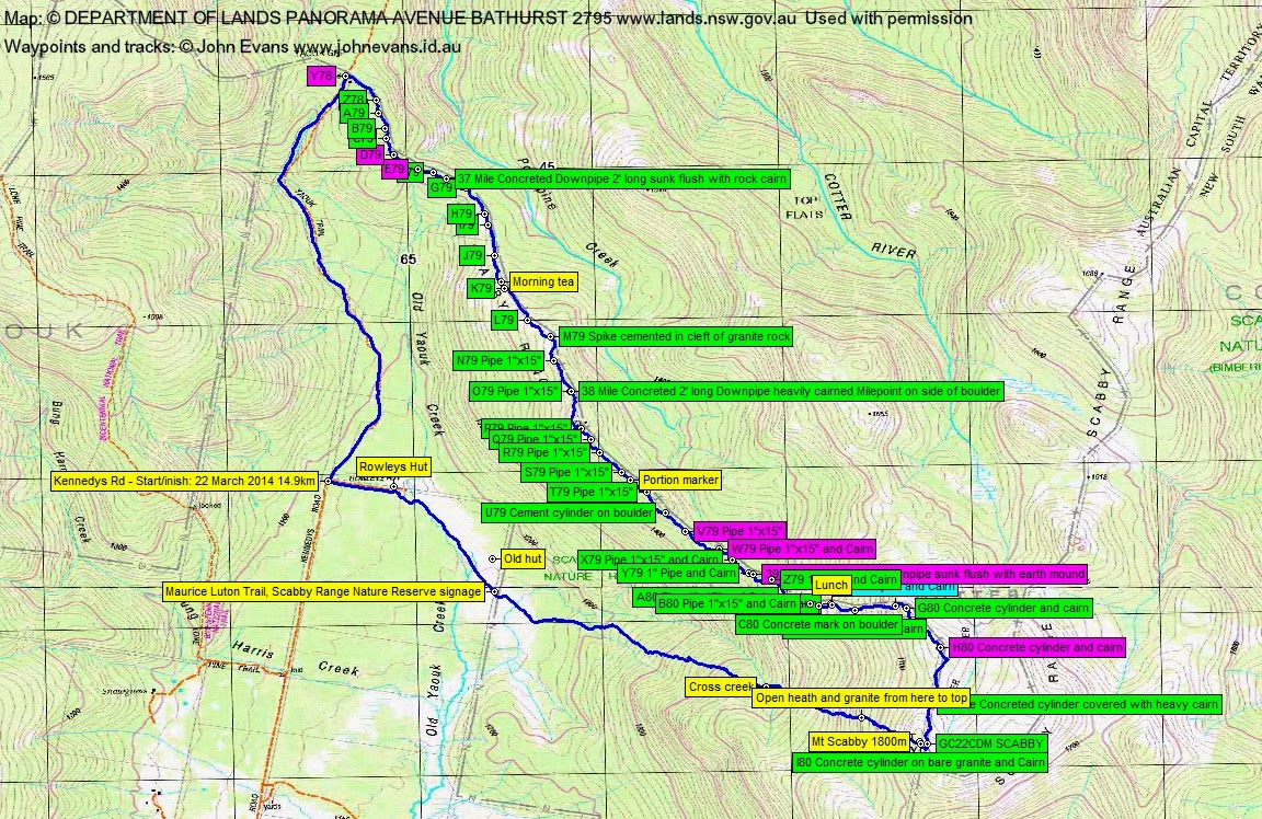
We started up the border on the ACT side, crossing and recrossing the old border fence on the ground many times. From Yaouk Gap to morning tea at 10.40am was 1.9km taking 1hr 5mins. A lot of pea regrowth, wet at first. It was slow going, even with the good system we have – Ian navigates via the route on his GPS and gets us to the next border marker (often finding it); he than takes off to the next whilst I photograph and record our find. At times during the hunting our Oregon GPSrs seemed to be unsettled. Stephen’s MAP60 GPSr came in handy, as it was a lot more accurate and steady. We found Z78, A79, B79, C79. Could not find D79 or E79. Found F79, 37 Mile, G79, H79, I79, J79.
Continuing after morning tea, we thought the going was about to produce open granite, but it was only a small area on the rise to the ridge NW of SH1473. The regrowth closed in again, and was particularly tight between N79 and 38 Mile. from morning tea to lunch at 1.20pm was 3.8km taking 2hrs 35mins.We found K79, L79, M79, N79, 38 Mile, O79, P79, Q79, R79, S79, (a portion marker which plots right on the corner of the Scabby Range Nature Reserve), T79, U79 (containing a cement cylinder in maybe the original surveying team’s lunch tin). We could not find V79 or W79. Found X79 and Y79. Could not find 39 Mile. Found Z79, A80, B80, C80 (concrete mark on boulder – in another lunch tin) and D80 that I sat on for lunch.
Lunch was at around 1600m and we then continued to climb through 1700m, finding E80 (with its 1″ pipe) and, possibly, F80.
G80, at around 1740m, finally brought us out onto the granite of the sub-alpine tops. My gloom departed as we changed from flapping chooks in the regrowth to soaring eagles in the open. Stephen thought that the feeling may have originated in the pain killers he took ;-). Lunch to G80 was 0.5km and took 25mins.
With our new-found energy we skipped along the tops admiring the views. Could not find H80, even though the original description and location pointed to another granite slab marker. Found 40 Mile.
Nearing the Mt Scabby top, we circled from the E so as to find geocache GC22CDM SCABBY. Signed the log. Came up to the Scabby cairn and border marker I80. It was 2.35pm.
A little discussion as to whether we should walk round through the saddle where the Cotter River rises and on to the little cliffette, where there was another geocache. It looked like around 45mins-1hr, so we decided not.
A straight line plunge down to the open Yaouk Creek flats. The first 400m across the ground was on granite and down herb fields. The rest was scrub and regrowth. From Mt Scabby to the Maurice Luton SRNR signage was 3km dropping 620m and taking 1hr 40mins.
From the signage we followed the indistinct Maurice Luton Trail to Rowleys Hut, then out the vehicle track to the car. 1.3km in 15mins.
A bit quicker trip home, as we beat a lot of the roos to the roads. The only strange thing was a little fire burning unattended right in the middle of Kennedys Road just before the ford of Bung Harris Creek. Obviously man made.
A quick stop at the Hospital Hill Lookout to bag geocache GCNV1H Gudgenby Gander.
Thanks lads.
Party
3 walkers – Stephen M, Ian W, me.