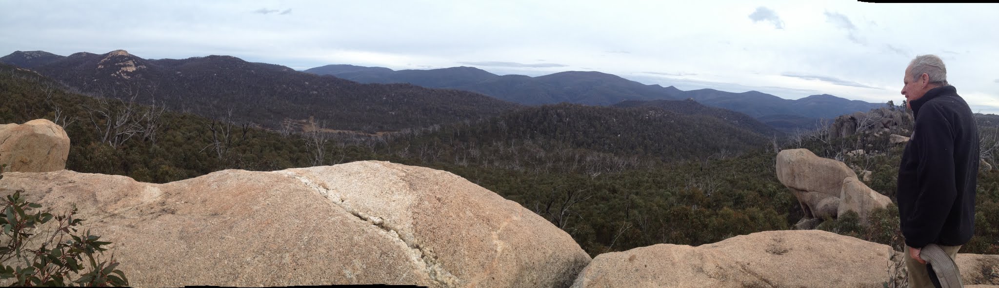
Rob surveys the view over Little Creamy Flats from the geocache site
Saturday-Sunday 17-18 May: Weekends in the southern Namadgi #3 1646 spot height above Little Creamy Flat – L/R. Day 1: Nursery then Rendezvous Creeks, roughly west via spot heights 1406 & 1571 to Little Creamy Flat. Day 2: Early morning climb then return via Pond Creek and AAWT. Maps: Corin Dam, Rendezvous Creek. Leaders: Jenny & Rob H. Transport: ~$32 per car.
6 of us drove in 2 cars to the Nursery Swamp car park. We then put a car at the Orroral Tracking Station car park.
Further Information
If time and leaders allow, search for:
GC41FGW Kids in the Nursery, GC1VFE3 Namadgi Art ? Bear right, GC1KM69 Nursery Creek, GC37J44 Squirrel’s Greater ROCK, GC37J43 Squirrel’s Lesser rock.
I was last in here on 22 Feb 11 – trip report here. I think I’m a little older and slower now and the Namadgi regrowth a little stronger!
Summary
Distance: 29.3km | Climb:1360m | Time: 2 days | Grading: L/R; H(12++)
Track Maps
Track overview

Track 1
Track 2

Track 3
Track 4
Track 5
Photographs
Photographs are available, where you can start a large sized slide show.
Video
Google Earth
Download the Google Earth .kmz file here.
Track Notes
Hours of pickup sticks; a dry camp; didn’t reach Little Creamy Flats or the hoped for geocaches. But 3 geocaches; fabulous scenery; identification of many parts of the old vehicle track into Little Creamy Flats. So who won? I’d call it a draw – Namadgi 3, us 3.
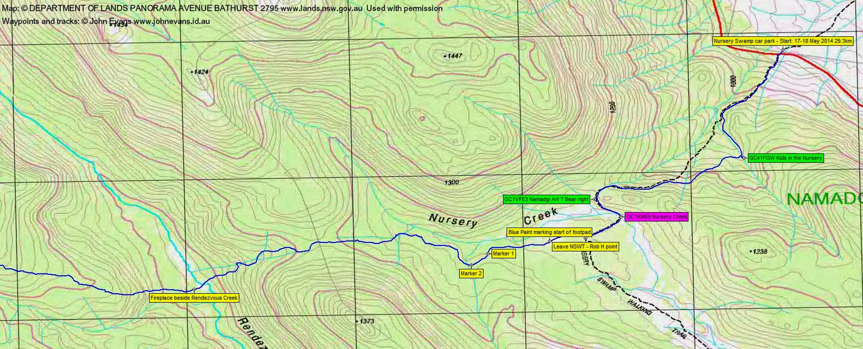
Walking at 8.25am. Going up the Nursery Swamp Walking Track the kind leaders allowed me to indulge my fancies via a couple of quick charges and a find of GC41FGW Kids in the Nursery and GC1VFE3 Namadgi Art ? Bear right. But no joy with GC1KM69 Nursery Creek. Hopefully I can have another look next Tuesday. And so on over the footpad and down to Rendezvous Creek. 5.3km in 1hr 40mins.
Here wise words we spoken – “pick up some more water in case we have a dry camp tonight”! So we did and had morning tea at the camp site on the west side of Rendezvous Creek.
Reasonable going as we climbed generally west from Rendezvous Creek, doing 1.3km in 45mins and climbing 170m. But at around the 1260m contour SE of SH1406 we hit the dreaded pickup sticks.
All you can do is grin and bear it, move slowly and carefully (an overnight bag changes your centre of gravity and pickup sticks would just love to break your leg) and perhaps try either up or down to get out of them. We went up and unfortunately it took us 2hrs 35mins to cover 1.3km (including lunch). An interesting pack pass and crawl just before lunch. Huge views to the Mavis Ridge as we sat on a splintered fallen tree to munch our energy. In the end we rounded SH1406 to the east and north.
Relatively easier going as we again headed west towards SH1571. 2.1km in 2hr 15mins.
Here we turned south for 500m in 45mins. Again, slow going as we checked our position. I must admit that I couldn’t relate ground to map at this time; not till later in the evening after a good pore over the map in my tent.
At 5pm with the light fading, we decided on a dry camp on the side of a hill. A little dirty water for some a bit of the way down the drainage line.
But it’s amazing how a camp fire engenders cheer and some hot tucker and a drink revived the spirits. 11 hours sleep. I missed the sight of a beautiful, nearly full harvest moon rising, but it was nearly light enough to read by it in my tent. A mild night.
Up at 6am. A lovely red sunrise a few minutes later. Options considered. It was obvious that with the speed of the party through the slow going, there was no chance to get over to Little Creamy Flats and our objectives above it – SH1646/ the geocaches on the Namadgi ‘bulb’. So the decision was to head for the saddle north of Little Creamy Flats, where an old vehicle track alignment heads down to intersect the AAWT. I pulled my trump card – an as yet unannounced geocache GC39857 A Mountain for mtbikeroz – down along the spur up above us and generally on our way out. So a happy compromise route was chosen.
We left at 7.30am and headed up to the saddle south of SH1571. Then generally NW along the spur to the geocache. Continued slow going – from the saddle to the cache site 720m in 45mins. What a superb location. Huge views! To the west we saw the Namadgi bulb, SH1646, Little Creamy Flats, Mt Murray, Little Bimberi, Bimberi Peak, Coronet Peak. A bit of a search revealed the cache (a hard cache owner with no hints). Logged GC39857 A Mountain for mtbikeroz.
Similar pace down to the saddle to begin our exit. 700m in 50mins.
I’ve had several goes at trying to map and follow the old vehicle track from the AAWT to Little Creamy Flats (shown on the 1st edition Rendezvous Creek 1:25000 topographic map). Here was the opportunity – a master route finder with his ‘drunkard’s stagger’ (moving from side to side to pick up the best going/find and follow a track); some waypoints from geocachers’ trips (GC37J43 Squirrel’s Lesser rock); some waypoints from my previous trips.
From a mercifully open area very close to the saddle we headed a couple of hundred metres to the NNW. Just 5m from a geocacher’s waypoint on the old vehicle track (OVT) the pea regrowth was over head high but, crashing through, we came upon a (barely) recognisable OVT. What I did from here on was to take a photo of the going and mark a waypoint when the OVT was discernible. It was recognised by vague footpad, barely discernible benching and gaps between the trees. Might have lost it coming down from OVT 05 to OVT 06 (we were well away from a geocacher’s waypoint), but Rob landed us right on the upper creek crossing. A stop for water and morning tea.
The OVT alignment was both discernible and most useful on the section from OVT 06 down to OVT 10. The route drops 100m over this 600m section.
From here, apart from a double back to OVT 11, we were lower and to the NE of the map marked and geocachers’ waypoints. Jen spotted another? cairn (I’d seen one near here a couple of years ago around 90m away) – I wonder what they marked?
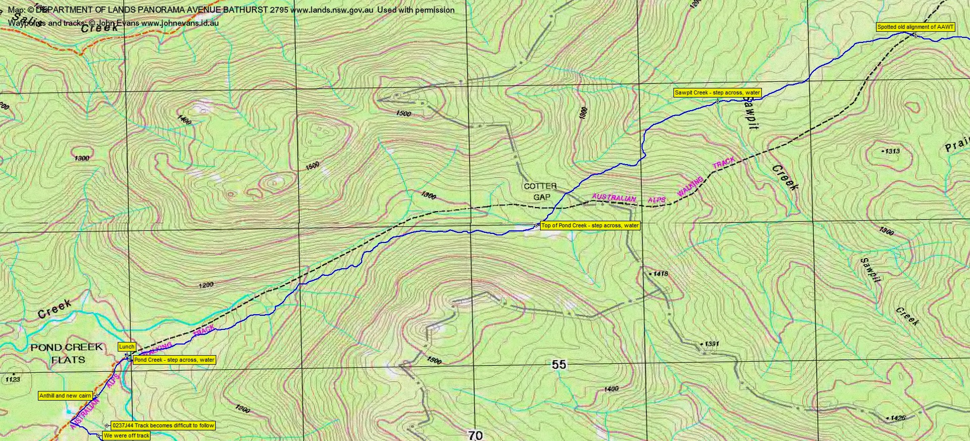
Rob took a large ‘drunken stagger’ and we ended up back on the track alignment at OVT 12 through to 0337J44 Old track spotted here. Then off the track alignment to join the AAWT (although finishing along a couple of hundred metres of tree-gap (another old track?)).
So our leg down the old vehicle track alignment was 4.3km taking 2hrs 55mins:

Lunch at the Pond Creek camp site. I was wrong and had forgotten that I have camped here on my first ever led CBC overnight trip on 5-6 Nov 05.
All that was left was to walk out. We left Pond Creek at 1:50pm and did the 11.5km to the Orroral Tracking Station car park, arriving at 5pm.
A tough Namadgi walk. I’m getting too old for this.
Party
6 walkers – Cynthia C, Doug G, Rob and Jenny H (leaders), Darren R, me.