Peter checks the temperatur
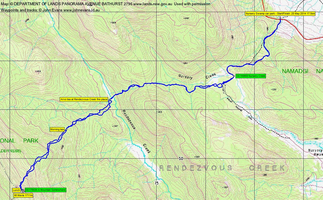
Tuesday 20 May: Mt Mavis Summit – L/R,ptX. Starting at the Nursery Swamp carpark we will follow tracks to Rendezvous Creek. We then head off-track to the 1700 metre summit of Mt Mavis GR723493, before returning on a different route to Rendezvous Creek. The off-track section is exploratory for the leader but it will be thick scrub in places with some rock scrambles. Minimum distance: 18 km with ∼900 metres of ascent. Maps: Rendezvous Creek. Leader: Ian W. Transport: ∼90 km return. Limit: 8.
7 of us drove in 2 cars to the Nursery Swamp car park.
Further Information
Look for geocaches GC1KM69 Nursery Creek and GC17BGN A Mountain Somewhere.
Summary
Distance: 17.5km | Climb: 1120m | Time: 7.30am-4.55pm (9hrs 25mins), with 50 mins of breaks | Grading: L/R; VH(15-)
Track Maps
Track overview
Track 1

Track 2

Photographs
Photographs are available, where you can start a large sized slideshow.
Video
No sound but the brisk breeze. You can see NW along the Mavis Ridge, the NE side of Rendezvous Creek, Mt Herlt, the Mavis cairn, Mt Burbidge, Mt Namadgi, Big Creamy Flats and the Namadgi bulb:
Google Earth
Download the Google Earth .kmz file here.
Track Notes
An early meet in town at 6.30am to conquer this hill in the current reduced daylight hours. We were walking by 7.30am and covered the 5.3km up the Nursery Swamp Walking Track and along the footpad across and down to Rendezvous Creek in 1hr 35mins. The chance to pick up water and have a quick breather. Showers about the hills and a brilliant rainbow – a portent o success to come! I was only given a brief time to look for GC1KM69 Nursery Creek and again failed to find it.
We climbed 1.2km and 160m up in 35mins before we were allowed morning tea at the 1250m contour. Occasional light showers.
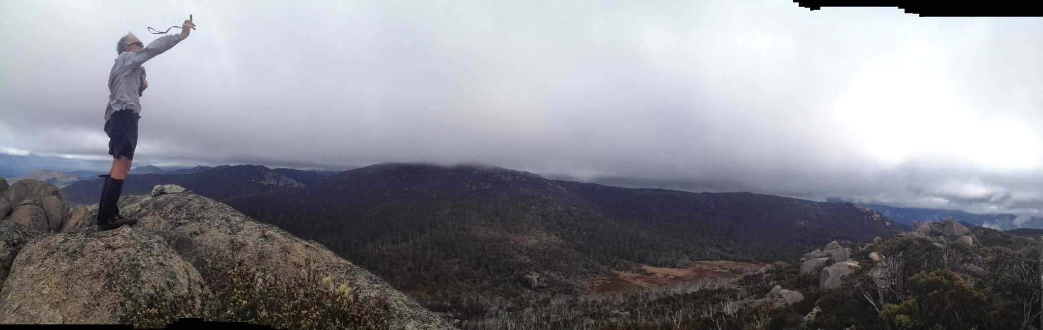
The remaining 2km to the top took us 2hrs 5mins, climbing from 1250m to 1711m, ∼460m (that’s over twice the height of Black Mountain above the lake). We hit the crest ∼100m NW of the top and sidled through dense regrowth at the foot of the gigantic tors till a way up was revealed. We scaled to the top tor with its little cairn. Huge views – the photos and video show it better than I can describe. Then most of us retreated out of the breeze for a quick lunch. A little hunting revealed the geocache GC17BGN A Mountain Somewhere for me. I was tempted to take one of the lovely little snakes, but had no swap.
The return trip seemed a little slower, the 3.4km descent taking 2hrs 23mins (but it was actually 20 odd minutes quicker).
We had a good breather at the fire place. I got Phillip to take a snap of me – I last lay about here on 7 Nov 08 coming back from a birthday day trip to Mt Namadgi. I’m older and slower now and my knee was sore after last weekend’s caning.
3.2km in 1hr back to the Nursery Creek bridge where, thank goodness, after a bit of faffing around, geocache GC1KM69 Nursery Creek was found. Too wet to sign so I took a photo. That Doh! moment when you’ve searched for it twice before and not found it.
A 2.2km (limp back for me) in 30mins back down to the cars.
Great walk, thanks Ian. We all suffered, but enjoyed the staggering views. Nice to get back to the Namadgi regrowth and granite. An ambitious walk with daylight hours shortening, but we did it.
Party
7 walkers – Peter C, Eric G, Linda G, Stewart J, Phillip S, Ian W (leader), me.
Guy Morrison
10 July , 2016 1:20 pmThat’s the route I/we used to climb Mt Boyle in the 1970s and I think the Canberra Bushwalkers then used the route from Orroral Road to Rendezvous Creek a bit as well. I think when we did that ascent we landed on the ridge somewhere between Mt Mavis and the knoll to its NW. We took a more straight line up instead of veering left to Mavis.