View NW from McKeahnie Trig

Saturday 11 January: McKeahnie Trig – M/R. McKeahnie trig from the Square Rock walking track. Opportunity for a different exit route. The hotter the forecast, the earlier the start. Back in town by 2pm. Around 15km and 450m climb. Map: Corin Dam. Limit: 8. Leader: John Evans – john@johnevans.id.au, 0417 436 877. Transport: ∼$7 per person. Further details at www.johnevans.id.au.
8 of us drove from Canberra to the Square Rock car park. ∼90km return, ∼$8.50 but kind passengers insisted on $10 (they must have gotten value for money in all the scrub).
Further Information
Look for geocaches ‘Square Stone’, ‘Orroral View’ and ‘McKeahnie Minor’.
Summary
Distance: 14.4km | Climb: 530m | Time: 7.05am-2.15pm (7hrs 10mins), with 1hr 5mins of breaks | Grading: M/R; H(12-)
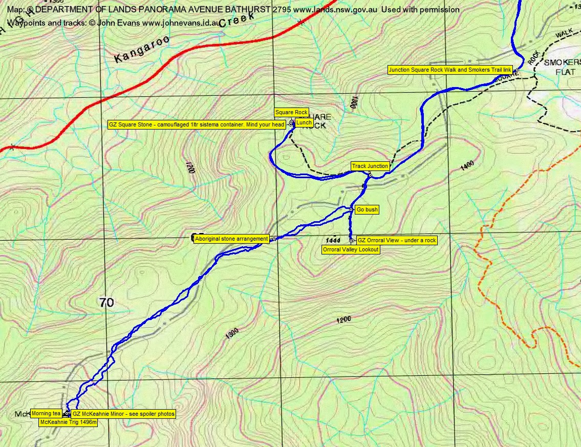
Track Maps
Track overview

Track 1

Track 2
Photographs
Photographs are available, where you can start a large sized slide show.
Video
Google Earth
Download the Google Earth .kmz file here.
Track Notes
Note that the Square Rock Walking Track has been realigned from the route marked on my 2006 vintage digital maps.
A calculated risk taking 2 I’d not met prior, but no trouble at all. The day got to 32°C in Canberra, but quite OK where we were. In fact, the bushes were damp as we wandered up the Square Rock Walking Track. 55mins for the 3.7km to the Orroral Valley Lookout. Spent 5mins looking for geocache ‘Orroral View’, but no joy.
Back a couple of hundred metres, we struck out for McKeahnie trig. First to what I suspect could be an indigenous stone arrangement, guarded by a band of head-high Pea regrowth.
Then, equipped with a couple of extra waypoints from our last exit on 12 Dec 12, and aided by a few patches of burning off, we made a better route in than last time by keeping to the NW side of the crest of the ridge for most of the way. But still plenty of regrowth. After the few hundred metres of open drainage line near the approach to the trig, a good patch of burning off made the last 200m to the trig a snack. From the Orroral Valley Lookout track to McKeahnie trig was 2.5km in 1hr 55mins.
The top of the knoll containing the garnite tors and the trig had not burned, so some tight scrub in there.
Now some of my bushwalking friends scoff at geocaching, but there was a big plus today. Armed with the GZ waypoint, 3 of us scaled a boulder near the trig via some fallen timber and worked our way round to the W side underneath the trig. I found the cache and enjoyed a closer-up view of the trig cairn. Never been this close before. So thanks geocaching! Morning tea.
1hr 50mins for the 2.5km coming back (I don’t know what caused the discontinuity in the track file recording).
A doddle to Square Rock for lunch. Rang home. Found ‘Square Stone’. Quite a few other walkers about. Sitting in the shade, a gentle breeze provided perfect evaporative cooling via sweaty backs of shirts.
Pleasant chatting on the way back. 4.2km in 1hr.
So only 3 more of the 87 accessible trigs left to do for the CBC ‘Stretch Your Legs’ event and a couple of caches. Plus a nice welcome to caching email and an invitation to walk to the Namadgi bulb (I think I’m too old and too slow) from a living legend cacher when I got home.
Party
8 walkers – Anthony B, Cynthia C, Roger E, Vin F, Chris F, Jade K, Phillip S, me.