View W and N from Tinderry Peak

Tuesday 27 May: Granite above Groggy Creek, Tinderries – M-L/R,ptX. A circuit to explore some Tinderries granite. From the Round Flat Fire Trail, up Roberts Creek and its north branch to the large area of granite, both boulders and slabs, at ∼066 E, 470 N (GDA 94). Should have good views to the north. Then we’ll decide the rest of the route from a number of options. Mainly off track, thick scrub in places, some steep slopes loose underfoot. Ascent at least 250 metres, other ups and downs. Map: Tinderry. Leader: Linda G. Transport: $48 per car. Limit: 8.
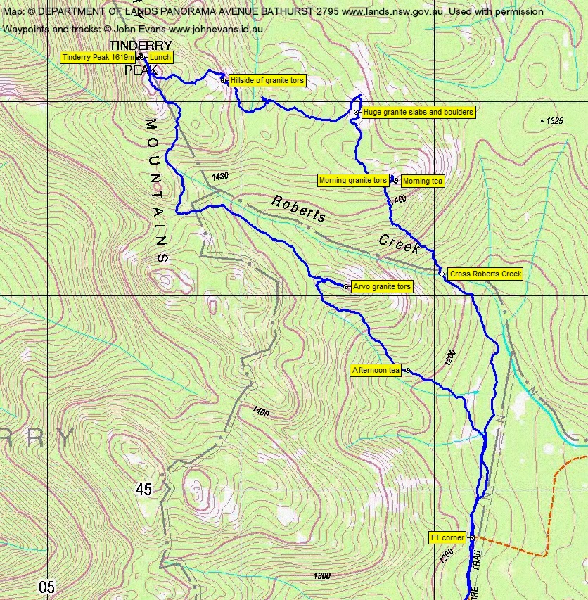
8 of us drove in 2 cars via Michelago up the Tinderry Road to the Round Flat Trail.
Summary
Distance: 12.7km | Climb: 630m | Time: 8.20am-3.30pm (7hrs 20mins), with 1hr of breaks | Grading: M/R; H(12)
Track Maps
Track overview

Track 1

Track 2
Photographs
Photographs are available, where you can start a large sized slide show.
Google Earth
Download the Google Earth .kmz file here.
Track Notes
Away down the Round Flat Fire Trail with the breeze already starting to rise. 1.7km in 20mins to the fire trail corner. Here we continued straight ahead along the Tinderry Nature Reserve boundary. A further 1.6km in 30mins along an old track alignment and through light forest to cross Roberts Creek.
From here we continued to the NW, 0.8km and climbing 230m in 40mins. We spotted a group of 7 or 8 goats. This took us to morning tea on Linda’s first objective – some granite tors and boulders, We sat out of the gusting wind on the SE side, with views out over Round Flat and the Tinderry Road winding into the distance. Braving being blown away, the views from the NW side were up to the Tinderry Ridge and Tinderry Peak and Twin Tinderry in the distance.
Our next leg was 0.6km in 25mins NNW to some huge granite slabs and boulders that Linda had sussed out on Google Earth. When not on the granite, the going was relatively open. Although a lot of fallen timber about.
Even Ian the granite hunter admitted that this area rivalled anything we’ve seen in the Namadgi. It extended even further than the slabs to the W of Boboyan trig. Great views out to the E. There were boulders too. We spent some time traversing the area. Exiting the area, most of the party skirted a huge one that seemed to be propped up on virtually nothing. Linda led 2 others crawling under and through it.
From her options, Linda set a westerly course for a hillside of jumbled, massive tors spilling down on the eastern flank of Tinderry Peak. 1.1km in 55mins, climbing 100m. We were instructed to have fun here, too, and you could see by the gleam in our leader’s eye that she was really enjoying this. We scrambled about the leads as best we could.
Emerging round the north side of the jumble at 11.40am, we had plenty of time for another objective. The map and various electronic gadgetry indicated that Tinderry Peak was only 500 odd metres away and 100m up. So off we went. 560m and 35mins saw us at the top, after a vigorous climb to the crest and a careful scramble NW along the boulders to the log book. The wind was howling and the views fabulous. Lunch in the lee, just off the top. A young wedge-tailed eagle was riding the wild skies.
We came off along the SE scramble, then S-ish across the very top of Roberts Creek to the saddle between Tinderry Peak and The Onion. A vague parallel down the side of Roberts Creek for a while, then to Linda’s last granite ledge. We’d had morning tea here on a couple of previous trips.
We backed out to the W, then down to the SE to join the old vehicle track and so to the FT corner. Tinderry Peak to here, with a detour and a couple of stops, was 4.2km in 2hrs 30mins.
Showers threatened, but we beat them back to the cars.
Any of these objectives would make a great Saturday walk.
This was an excellent day. Apart from the first 2 planned objectives, this was a free form day, taking us to wherever looked good. Great leadership and navigation.
Party
8 walkers – Peter C, Roger E, Eric G, Linda G (leader), Jenny H, Stewart J, Ian W, me.