Great views from the top of Emu 06 cluster of tors to Split Rock, de Salis knobs, Dutchies Peak and Mt McKeahnie

Tuesday 3 June: Rocky Spurs, Head of Orroral Valley – L/R,ptX. Starting at the Orroral Tracking Station site we will walk to the edge of the grasslands at the northern end of the valley. We follow Smokers Trail north for a few kilometres then head off-track for a few hours to visit rocky outcrops between Booroomba Creek and Emu Flats. We descend to the valley and then walk 7 km back to the cars. The off-track section is exploratory and likely to be slow going in thick scrub with some rock scrambles. Minimum distance: 23 km with ∼600 metres of ascent. Maps: Rendezvous Creek, Corin Dam Leader: Ian W. Transport: ∼95 km return. Limit: 8.
5 of us drove in 2 cars to the Orroral Valley Tracking Station site car park.
Further Information
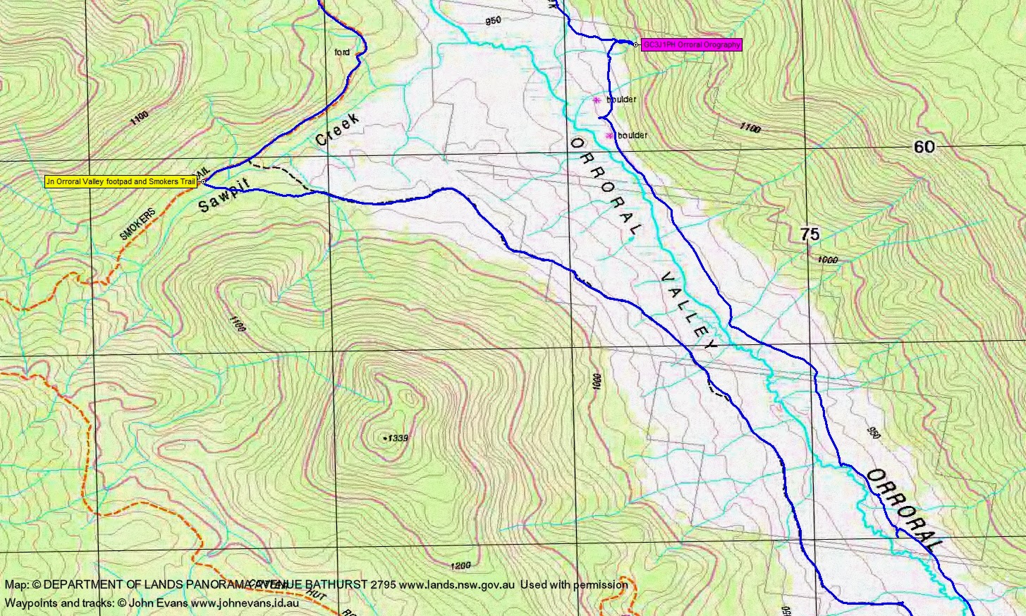
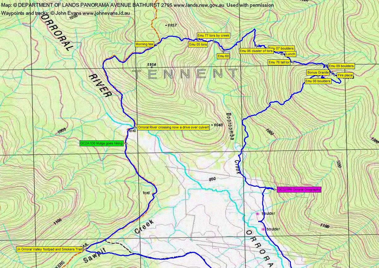
Depending on route and available time, look for geocaches GC2A1D0 Mulga goes hiking and GC3J1PH Orroral Orography.
Summary
Distance: 23.1km | Climb: 830m | Time: 8.00am-4.35pm (8hrs 35mins), with 40 mins of breaks | Grading: L/R; H(14-)
Track Maps
Track overview

Track 1
Track 2
Track 3
Photographs
Photographs are available, where you can start a large sized slide show.
Videos
Google Earth
Download the Google Earth .kmz file here.
Track Notes
A day of many lessons learned, leg-stretching entry and exit, great granite, huge views.
Lesson #1 was to brake hard to avoid roos (3 big fellas, not your $1500 damage causing wallabies) on the Orroral Road.
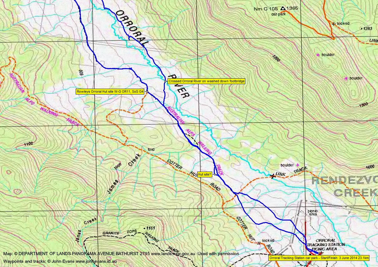
Walking right on 8am with the sky threatening and a stiff breeze. We made 7.3km in 1hr 25mins up the west side of the Orroral Valley via the sometimes mown walking track. (Note that the track joining Smokers Trail and bridge over Sawpit Creek is a little to the SW of the map-marked position. Eagles soaring over the valley. An additional 3.5km in 45mins along Smokers Trail to morning tea. Some interesting fungi. Found geocache GC2A1D0 Mulga goes hiking and crossed the Orroral River via a vehicle-drivable culvert.
Next began a granite visiting loop to the E and SW which took us up and down and around to near Booroomba Creek E of SH1048. 4.5km in 4hrs 10mins (including a 30min lunch).
We were immediately in the granite, with some bonus tors appearing. The scrub was initially quite manageable (and thankfully dry), but it thickened as we began the 100m descent to Booroomba Creek. Emu 05 tors were the first that Ian the granite hunter had mapped out for us and impressive too. Emu 77 tors as we reached the creek.
Booroomba Creek was delightful and flowing strongly. (Maybe a trip down it on a hot summer’s day?) The scrub near the creek line was lush and wet. Then a contour round a bit of a spur and a time wandering a few hundred metres up along a flowing feeder creek. Heard a wild dog howl somewhere around the Orroral Valley – the first one I’ve heard for a couple of years.
Turning S, we arrived at Emu 06, a cluster of most impressive tors. They entertained us in fine style, with huge walls on arrival, clambering and scrambling up through a major slot, and huge views W to Dutchies Peak and Mt McKeahnie and beyond from the top. A great place!
Continuing just S of E, we arrived at Emu 07 boulders and scrambled up the top for lunch. Quite a ‘conference centre’ on top – a large, flat area with plenty of seating.
With bolstered energy (but creaking knees from the stop), we continued just S of E past Emu 76 tall tor to explore Emu 09 boulders. Great views again from the top.
Ian thought he’d spied something further up the hill, so we climbed to the SE to another lot of bonus granite. Lesson #2 for me – I always thought that walking at the back of the party (and in shorts) was a safe thing, but not when a European wasp nest has been trampled and the occupants are looking for revenge. 3 stings for me and some bad language. But the granite was worth it. A fire place nearby.
Ian thought the top of the spur might give us a view (and be easier going). Not on both fronts.
So we circled the wagons, visited the last site for the day at Emu 08, then began the 300m descent to the valley. Hit the side of the open valley at 2.30pm.
Here I was given my head to find the second geocache. We continued S down Booroomba Creek over squelchy tussock and, whilst the others had an afternoon tea break, I headed back into the tree line for the cache. Lesson #3 for me – read the cache description! It was located in a beaut cave (but no GPSr reception) and I didn’t bring the spoiler pic with me. Doh!
Back with the others, we set off again. You can see on the map segment, between the two map-marked boulders, where we headed towards the Orroral River. Ian and Meredith braved wet feet and crossed; I joined the mutineers who headed downstream on the true left bank with dry feet. Ran into a big Outward Bound party. We crossed the river at the old sheep bridge site and wandered back to the cars.
A very good walk!
Party
5 walkers – Eric G, Meredith H, David P, Ian W (leader), me.