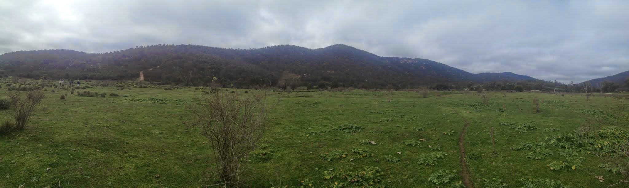
Tennent N ridge from Blue Gum Creek flats
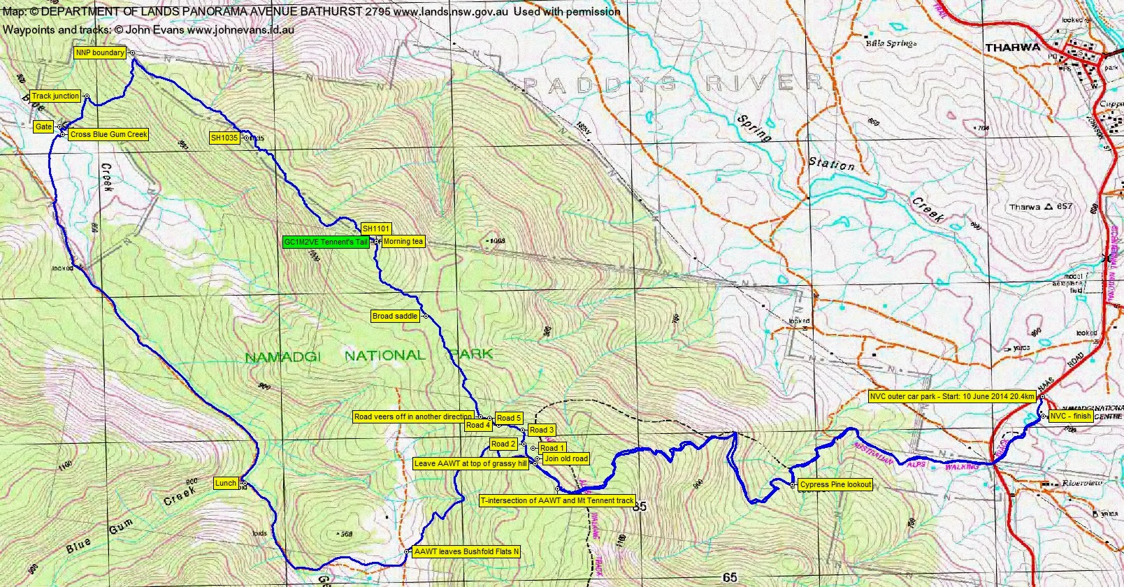
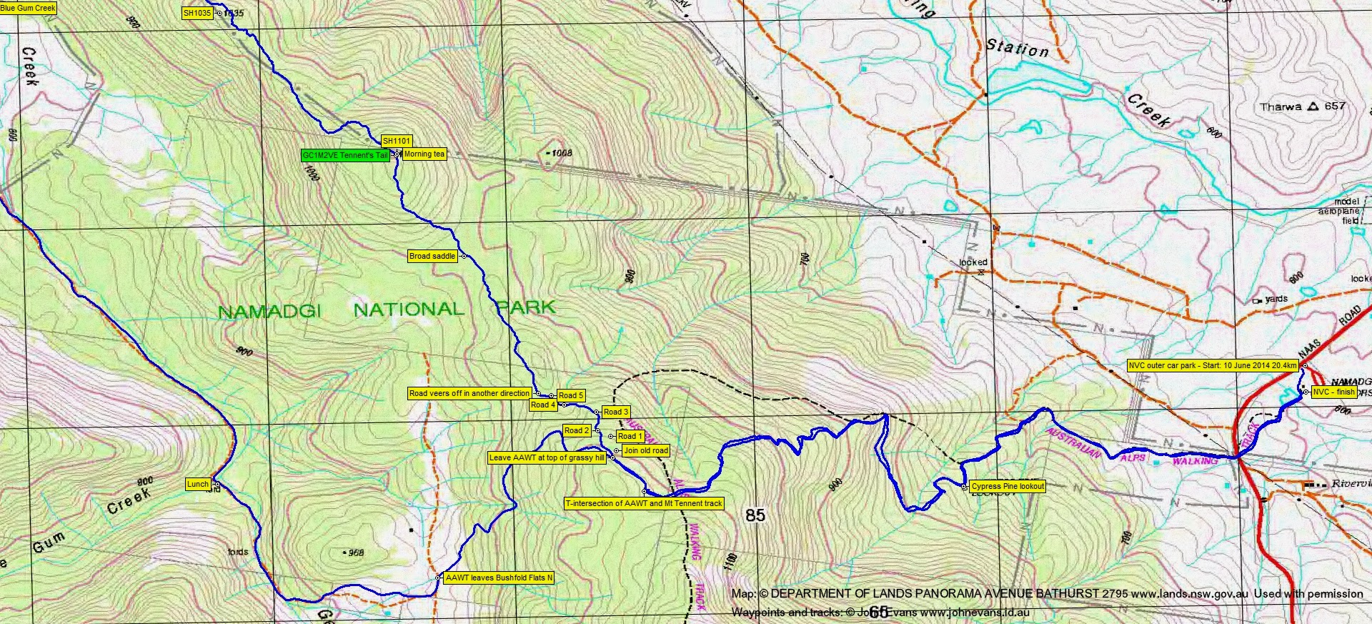
Tuesday 10 June: Tennent North Ridge and geocache GC1M2VE Tennent’s Tail – L/R,ptX. Mt Tennent has a north-west ridge system that extends out through SH1101 and SH1035 to Booroomba Trig. Let’s have a look. From the Namadgi Visitors Centre, AAWT to just past the T-intersection, then a bush-bash B-line to SH1101. There is a geocache there. Return south via the Dunns’ hut site to rejoin the AAWT at the northern end of Bushfold Flats and so home. Around 16km and 850m climb. An optional additional few km would take us to SH1035, then down across an arm of Blue Gum Creek to the Georges Creek fire trail. Map: Williamsdale. Limit: 8. Leader: John Evans – john@johnevans.id.au, 0417 436 877. Transport: ~$5 per person. Further details at www.johnevans.id.au/wp. Emergency contact details must be registered/provided to book.
6 of us drove in 2 cars to the Namadgi Visitors Centre. Always wise to park in the outer car park, in case the party is held up.
Summary
Distance: 20.4km | Climb: 1050m | Time: 7.45am-2.40pm (6hrs 55mins), with 50 mins of breaks | Grading: L/M-R,ptX; H(13-)
Track Maps
Track overview
Track 1
Track 2

Photographs
Photographs are available, where you can start a large sized slide show.
Google Earth
Download the Google Earth .kmz file here.
Track Notes
I think we did other walkers a favour today – there is little need to to walk along the north Tennent ridge. It’s moderately scrubby and fairly uninteresting – as the photos show.
4.5km in 1hr 11mins from the Namadgi Visitors Centre to the T-intersection on the north Tennent ridge. Interestingly, I’ve recently met ‘Bear Grylls’ (a Royal Marine officer) who, last Wednesday, did the top of Mt Tennent in 1hr!
We then wandered along the AAWT for a bit, then turned N to NW using a series of waypoints provided by geocacher Noikmaster at the GC1M2VE Tennent’s Tail listing. It took us (after re-starting my GPSr which was playing up) via an old vehicle track alignment down along the ridge for a while. After the alignment veered away down to the W, we just headed along the ridge towards SH1101 and the geocache. Manageable going at first, then some wattle regrowth, then some tight shrubbery (as described in the geocaching logs). Arrived at the SH and an easy find of the cache on top of a boulder. 2km in 50mins from leaving the AAWT to the cache. Morning tea was taken at 10am.
It was a bit early to turn for home (grin), so we activated our alternate route which would add a bit more new country and km and time. The going immediately changed to more open as we drifted down the NW side of SH1101. From there to SH1035 was a mixture of going – some open, some tight shrubs, the granite of the crest showing every now and then. Again, on the N flanks of SH1035, the going was a little more open. There were views to the grazing paddocks NE and SW. we finally reached the fence line of the NNP boundary. From SH1101 to the NNP boundary was 2.2km in 1hr 5mins.
Between us and Blue Gum Creek was a sea of shrubs, but a handy old vehicle track paralleled the fence to the S, then turning away to the SW. As the track turned to the NW I thought we were stuffed, but we came upon a track junction and another track down towards Blue Gum Creek. I’m afraid we strayed onto the Booroomba property to cross Blue Gum Creek at a handy rocky skip-across (better than the swampy wide crossings down near Blythburne Cottage), but headed for the fire trail beside the Park boundary as soon as we could. Gates coming out of the Park area and going back into it provided handy fence-crossings. 1.4km in 23mins down off the Tennent N ridge, across Blue Gum Creek and onto the fire trail beside the Park.
A trudge of 2.4km in 27mins along the fire trail to cross Blue Gum Creek at the ford and stop for lunch.
Departing from lunch at 12.45pm, a wander up to the N end of Bushfold Flats, up the AAWT to the crest and back down to the Visitors Centre. 7.5km in 1hr 55mins.
Hadn’t been along the N Tennent ridge before; no need to go back.
Party
6 walkers – Roger E, Eric G, Stewart J, Alison M, Ian W, me (leader).
Next Tuesday Walk
Tuesday 17 June: Yanununbeyan State Conservation Area and National Park – L/M,X. Another exploratory trip in the woodlands and open forests of the Yanununbeyan SCA and National Park near Captains Flat. A long day of off-track ridge and creek walking, but on a different route to the walk of 29/4/2014. The scrub is fairly light and the route taken will try to minimise the amount of distance covered on fire-trails. Minimum distance: 20 km with ∼700 metres of ascent. Maps: Captains Flat, Hoskinstown. Leader: Ian W. Transport: ∼115 km return. Limit: 8.
Contact Ian directly with enquiries and for bookings. If you don’t know how, contact me via the CONTACT INFO below.