On the spur south of Primrose Valley Creek, descending to Woolcara Lane
Tuesday 17 June: Yanununbeyan State Conservation Area and National Park – L/M,X. Another exploratory trip in the woodlands and open forests of the Yanununbeyan SCA and National Park near Captains Flat. A long day of off-track ridge and creek walking, but on a different route to the walk of 29/4/2014. The scrub is fairly light and the route taken will try to minimise the amount of distance covered on fire-trails. Minimum distance: 20 km with ∼700 metres of ascent. Maps: Captains Flat, Hoskinstown. Leader: Ian W. Transport: ∼115 km return. Limit: 8.
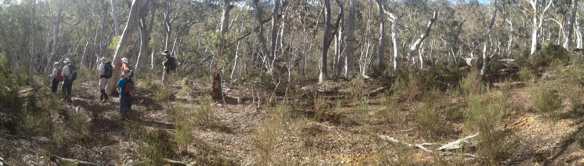
7 of us drove in 2 cars to the Apple Box Flat Day Use Area on Woolcara Lane.
Summary
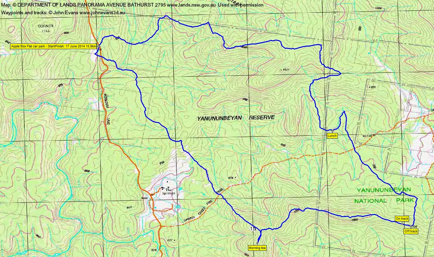
Distance: 15.9km | Climb: 610m | Time: 8.10am-2.45pm (6hrs 35mins), with 45 mins of breaks | Grading: L/M; M(10)
Track Maps
Track overview
Track 1
Track 2

Photographs
Photographs are available, where you can start a large sized slide show.
Google Earth
Download the Google Earth .kmz file here.
Track Notes
An extremely pleasant walk through the open dry sclerophyll woodland spurs, ridges and drainage lines of the Yanununbeyan Reserves. target=”_blank”
We parked at the Apple Box Flat Day Use Area and first did a little detour to the west of Woolcara Lane. I suspect it was to have a look at the flats, but reaching the sunshine was a real bonus. The morning was clear, but crisp.
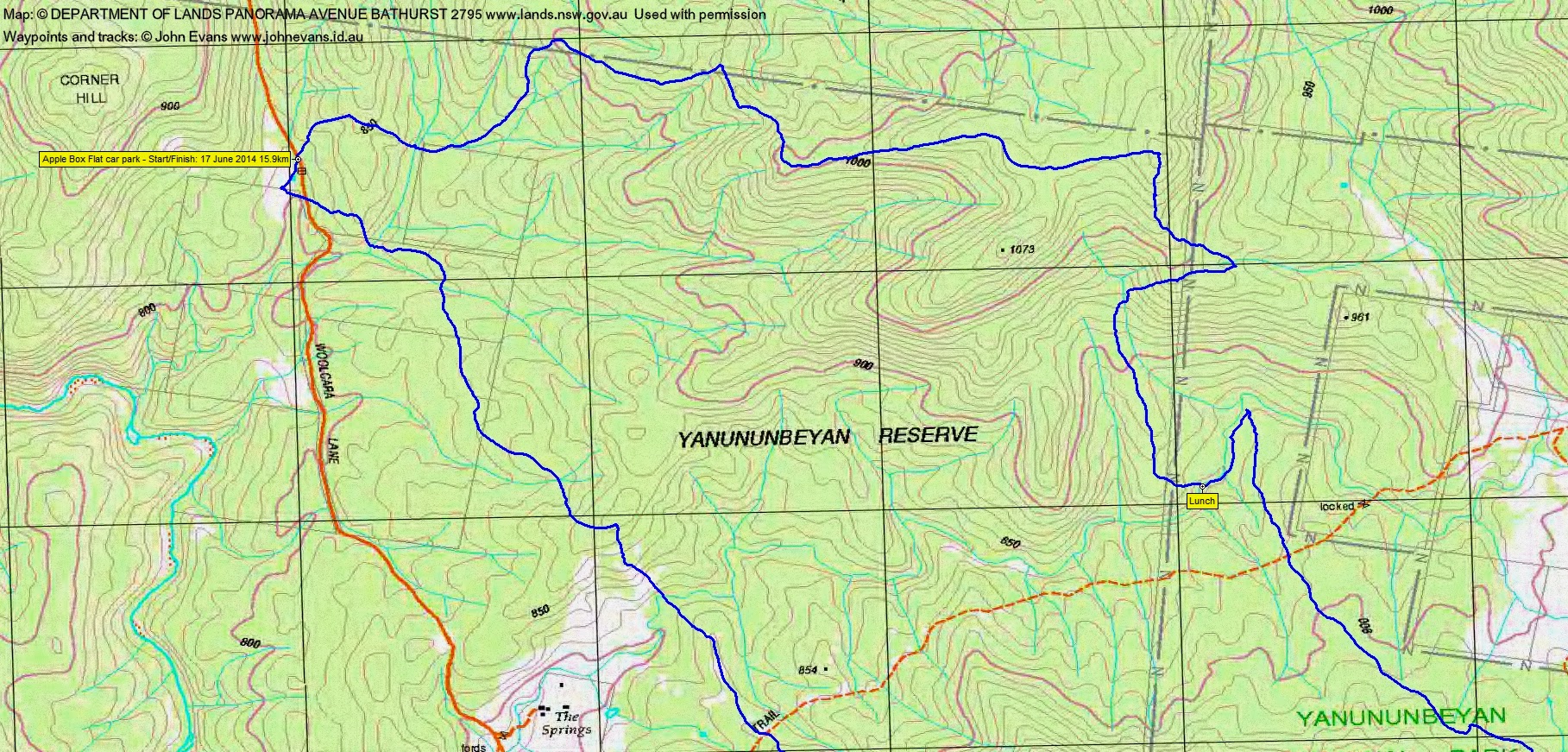
Then a gentle up, down, up, down and up to the SE to cross Spring Creek Fire Trail, followed by a bit steeper (but still only ∼100m climb) climb to a major ridge and to morning tea. 4.4km in 1hr 35mins to here.
The next leg was generally East along the ridge and knolls into the Yanununbeyan National Park section. Approaching SH996, we crossed an old fence line and picked up a vehicle track – for 150m. Then North, then NW down to cross the Spring Creek Fire Trail again. Further to the N we struck a creek line and turned south-ish to follow it for a while to lunch. From morning tea to lunch was 5.4km in 1hr 50mins.
Leaving the lunch spot at 12.30pm we wandered generally N (with a detour to the E to see what was at an open spot on Google Earth), then up onto a ridge system and so generally W down the open spurs to the cars. The afternoon leg was 6.1km in 2hrs 15mins.
A walk with no particular points of interest, but a lovely stroll through country so different to Namadgi regrowth.
Party
7 walkers – Eric G, Jenny H, Stewart J, Lucy L, Phillip S, Ian W (leader), me.
Next Tuesday Walk
Tuesday 24 June: Bullen Range South – L/M. From locked gate at entrance to Paddys River Travelling Stock Reserve off Tidbinbilla Rd ascend to Barnes Trig (825m) then N along crest of Bullen Range on fire trails for 10km past Brett Trig (881m) to large microwave tower 1km N of Canberra Deep Space Tracking Station before turning off track to return S along W flank of Range following contour where possible and convenient wombat trails. Occasional views over Murrumbidgee and Paddys River valleys from Range crest. Lunch on hillside overlooking Tracking Station. For off-track leg expect dense scrub in numerous small creek beds (usually dry) but fairly open elsewhere. Detour to locate and inspect Calvery mud brick hut ruins at GR8223-7722 (MGA94) on final climb to Barnes Trig before descent to start. Estimated 22km and 700m total climb. Cost $20 per car. Limit 12. Maps: Tidbinbilla and Tuggeranong. Leader: Eric G.
Contact Eric directly with enquiries and for bookings. If you don’t know how, contact me via the CONTACT INFO below.