‘Calvary’

Tuesday 24 June: Bullen Range South – L/M. From locked gate at entrance to Paddys River Travelling Stock Reserve off Tidbinbilla Road ascend to Barnes Trig (825 m) then N along crest of Bullen Range on fire trails for 10 km past Brett Trig (881 m) to large microwave tower 1 km N of Canberra Deep Space Tracking Station before turning off track to return S along W flank of Range following contour where possible and convenient wombat trails. Occasional views over Murrumbidgee and Paddys River valleys from Range crest. Lunch on hillside overlooking Tracking Station. For off-track leg expect dense scrub in numerous small creek beds (usually dry) but fairly open elsewhere. Detour to locate and inspect Calvary mud brick hut ruins at GR8223-7722 (MGA94) on final climb to Barnes Trig before descent to start. Estimated 22 km and 700 m total climb. Maps: Tidbinbilla, Tuggeranong. Leader: Eric G. Transport: $20 per car. Limit: 12.
3 of us drove in 1 car to the gate into the Paddys River stock route/Miowera Pine Forest.
Further Information
If appropriate, look for geocaches on the way.
Summary
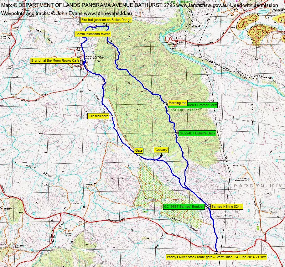
Distance: 21.1km | Climb: 675m | Time: 8.00am-1.40pm (5hrs 40mins), with 50 mins of breaks | Grading: L/E-M; M(11)
Track Maps
Track overview
Track 1

Track 2
Track 3
Photographs
Photographs are available, where you can start a large sized slide show.
Google Earth
Download the Google Earth .kmz file here.
Track Notes
Forecast was for showers, high winds, max 8°C and snow down to 700m the previous day, so we waited for a final go from Eric at 6am. It was thumbs up as the forecast had eased a little, but only the three musketeers were brave (or foolish) enough to turn up.
I bought a new pair of boots yesterday – Hi-Tec Altitudes from Seears Workwear at Fyshwick. $208.05 when you flash your Seniors Card. Still love these boots! 21km on their first walk and dry, comfortable feet. 5 layers (including shell) on top and thermal bottoms, gloves, beanie and neck warmer – so warm and dry in mostly high wind, showery, cold and snow flurry conditions.
That Doh! feeling when you switch on your GPSr and there are no waypoints or (even worse) geocaches. Man, am I getting old and stupid. That Whew! feeling when you realise that there is mobile reception at least along the crest of the Bullen Range, so the Geocache app will work.
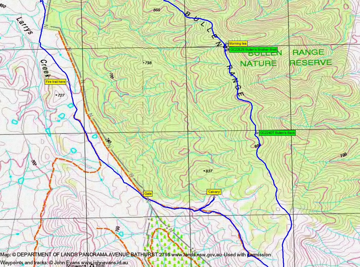
Very blustery as we headed up the fire trail from the car. Plenty of snow on Mt Tennent as we drove out. Glimpses of snow on the Tidbinbilla Range. We hurried up Barnes Hill where I quickly found GC198B7 Barnes’ Boulder. Then down and up and along and up into the wooded area of the Bullen Range crest. Took a little while to find GC224DT Bullen’s Back and I was lagging behind without telling the leader that I’d left the main line. Bad boy JohnnyBoyACT; apologies Eric the leader. Caught up with the others, then went ahead to quickly find GC22EZ6 Bullen’s Brother Brett. We stopped for an early morning tea at 9.25am just on the East side of the crest near Brett trig, out of the wind. 6km in 1hr 25mins to here.
Our next leg was to continue North along the fire trail. This fire trail was put in after the 2003 firestorms and, I guess, is the last line of defence for south Canberra. From Brett trig to the fire trail junction where we left the crest was 3.8km in 45mins. Great calling from the male Lyrebirds.
We’d seen the comms tower. We turned West and descended past it and down out of the Bullen Range Nature Reserve towards the Tidbinbilla Tracking Station. One can pray “… lead us not into temptation” but I think it was moi who suggested we could have a coffee at the Moon Rock Cafe! We wandered down along the East perimeter fence (passing good geocaches, but there was no mobile reception down here), waving to the video cameras. There are some powerful looking perimeter lights too.
Along to the public entrance and so to the Moon Rock Cafe, where a warm environment provided an excellent brunch. The descent to here was 2.2km in 30mins.
I think brunch was my undoing. Eric had, indeed, recce-d this walk and no doubt had a fine route for us back along the western flanks of the Bullen Range, going down and up across the multiple drainage lines and through the wet scrub. So I suggested that the local farmer might “… forgive us our trespasses” and convinced our good leader that we could return along the open paddocks NEAR to the BRNR. We made from the Tidbinbilla Tracking Station (actually the Canberra Deep Space Communications Complex – CDSCC) to the gate where we finally got legal, 4.1km in 58mins.
‘Calvary’ is easier to find from the bottom than the top. We wandered up the vehicle track to a suitable (and from memory) looking footpad and followed it a bit to pick up the fence line that leads to the pise homestead site. Looks like a bit of wattle lopping has been done. 760m in 12mins. A nice look around.
Returned to the vehicle track and, although the lower fire trails through the growing pine seedlings look attractive, we climbed to the crest (apart from a little look down). Back through Barnes trig, with a bit of snow flurry, to the cars. This last leg back from Calvary was 4.2km in 1hr.
A good walk for the day’s weather. Nice to test our wet/warm gear.
Party
3 walkers – Eric G (leader), Ian W, me.
Next Tuesday Walk
Tuesday 1 July: Yanununbeyan National Park – L/M,X. An exploratory trip, mainly off-track, in the woodlands and open forests of the Yanununbeyan National Park, We start from the main road 8 km north of Captains Flat and spend the day walking the ridges and creeks in the northern part of the reserve. Minimum distance: 22 km with ∼860 metres of ascent Map: Captains Flat, Hoskinstown. Leader: Ian W. Transport: 112 km return. Limit: 8.
Contact Ian directly with enquiries and for bookings. If you don’t know how, contact me via the CONTACT INFO below.