Westermans Homestead
Tuesday 8 July: Grassy Creek and beyond – M/M. Starting at Brayshaws Hut we’ll walk the first section of the Settlers Track to Waterhole Hut, then leave the track and make our way up Grassy Creek past two vestigial sites. We’ll get onto the Bobeyan Divide and see several of Harry Mouat’s border survey marks dating from 1915, then make our way back down the valley to Westermans Homestead, and back to Brayshaws. About 15 kilometres, on and off track, including untracked forest. Maps: Yaouk and Shannons Flat. Leaders: Matthew Higgins (guest leader) and John Evans – john@johnevans.id.au, 0417 436 877. Limit: 16. Transport: ∼$15 per person. Emergency contact details must be registered/provided to book.
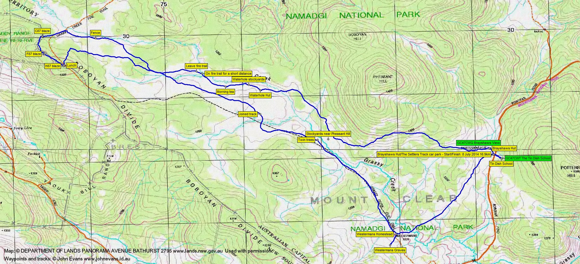
16 of us drove in 4 vehicles to the Brayshaws Hut/Settlers Track car park.
Further Information
If appropriate, look for GC47CWQ Brayshaws View, GC47CWT The Tin Dish School and clues for GC2JX02 Wander back in time at Waterhole Hut and Westermans Homestead.
Summary
Distance: 16.9km | Climb: 370m | Time: 9.20am-3.10pm (5hrs 50mins), with 40 mins of breaks | Grading: L/E-M; M(10)
Track Maps
Track overview
Track 1

Track 2

Photographs
Photographs are available, where you can start a large sized slide show.
Google Earth
Download the Google Earth .kmz file here.
Track Notes
A tremendous day, with Matthew adding such a depth to the experience of landscape via sharing his knowledge of history and use of the sites we passed by. Everyone had an excellent time.
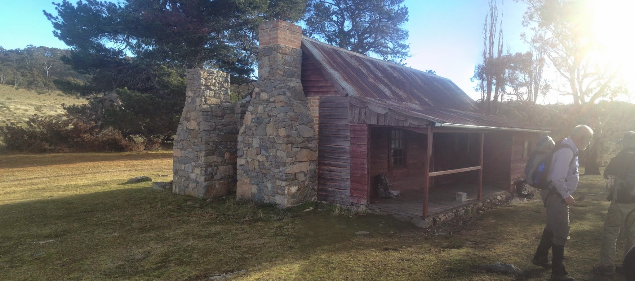
We shook out and whilst the party viewed and heard about Brayshaws Hut, I scurried up a nearby little knoll to find GC47CWQ Brayshaws View.
Then along the Settlers Track, stopping every now and then for a view down across the Grassy Creek valley to Westermans Homestead and later to the stockyards under Pheasant Hill. We learned why the signage posts were being dug out – kangaroos like the salt leeching from the concrete bases, just as in days gone by graziers would put out a salt lick to bring the stock in.
Just before crossing the steel walk-way over Grassy Creek below Waterhole Hut, we stopped and Matthew pointed out the two different styles of old fencing – post and rail on the true left side of the creek and drop log on the true right.
Up to Waterhole Hut where our guide again gave us more of the history than is on the signage. Time for a poke around (and for me to gather answers to solve GC2JX02 Wander back in time. Then down to view the Waterhole stockyards.
We left the track here and wandered over to a slight knoll for morning tea. The breeze dropped the temperature a few degrees to brisk, but not painful. The sky was still overcast. 4.5km in 1hr 20mins to here.
From here we continued up the valley to a couple of near-by sites. One was the Crawford-Perry Hut site and the other the Burnt Camp site. Matthew told us the story of each. The latter is recorded in his book Rugged Beyond Imagination – I’ll have to reread it from cover to cover to find where.
We continued up the valley (a better route than I’ve ever used), crossed a major old fence line and came to the Grassy Creek Fire Trail very near its elbow. a short detour in to the C87 blaze and the story of the survey of the ACT border. Next, via the NSW side of the border, we turned south through the F87 blaze and so to the H87 blaze and lockspit for lunch. From morning tea to lunch was 3.6km in 1hr 20mins.
After lunch we walked down through the light timber to the open valley floor and headed back to the south-east. A little touch of snow lying in a protected hollow. A very pleasant route, one which I must use next time, as I’ve done the New Grassy Creek FT along the border alignment to death. We eventually joined the map-marked Grassy Creek FT.
Where the track was opposite the Pheasant Hill stockyards, Matthew veered off a few tens of metres to the most remarkable pair of trees, growing as bosom-buddies. A Black Sallee (Eucalyptus stellulata) and a Mountain Gum (Eucalyptus dalrympleana).
Back on the fire trail we wandered on, now in the sun, to Westermans Homestead and the Westerman graves. At the homestead I was again able to solve clues for the geocache GC2JX02 Wander back in time, but as we’d visited Westermans and Waterhole in the reverse order to the cache multi, I’ll have to go back for the final GZ. Lunch to Westermans was 6.5km in 1hr 45mins.
Our last leg was back to the cars on the Boboyan Road, 2km in 30mins.
We skipped across the road and the walked the short distance up to the Tin Dish School site. Of course my interest was geocache GC47CWT The Tin Dish School, which I was able to find and log.
Huge thanks to Matthew, our drivers and the whole party for a most excellent day.
Do purchase a copy of Matthew’s book Rugged Beyond Imagination by Matthew Higgins, National Museum of Australia, Canberra 2009 to read about the great heritage of this and other parts of the ACT and surrounds.
Party
16 walkers – Margaret C, Stuart C, Chris F, Eric G, David and Meredith H, Matthew H, Jenny H, Stewart J, Alison N, Wayne P, Max S, Phillip S, Victoria W, Ian W, me.
Great to have one of the queens of Canberra social media and twitter maniac @chifley_alison with us. She and many other local twits tweeters also champion Namadgi National Park and the bush.
Next Tuesday Walk
At the moment there is no walk next Tuesday 15 July. The next Tuesday walk is:
Tuesday 22 July: Nuggetty State Conservation Area – L/M/X. This is an exploratory walk 40 km north of Crookwell. The Nuggetty SCA is rugged country of about 6 km x 3 km, with numerous steep gullies and ridges covered by dry grassy woodlands. Emergency contact details must be registered/provided to book. Minimum distance: 4 km of fire trail and 15 km off-track. ∼900 metres of ascent. There is a 2h 20m drive each way. Map: Bigga 1:50,000 Leader: Ian W. Transport: 380 km return. $140 per car. Limit: 8.