Tidbinbilla Ridge, Mt Eliza and the main tor from Gibraltar Peak
Saturday 13 September: Yet more Gentle Geocaching at TNR – L/E-M. Tidbinbilla Nature Reserve has provided some excellent rambling over the last few weeks, taking us on trails that I’ve not previously walked. Today’s sample will be the new Gibraltar Peak track, over Eliza Saddle and around the Birrigai Time Trail. More if time and inclination allow. Caches galore! Around 15km and 600m climb. Mainly on track. Map: Tidbinbilla. Leader: John Evans, john@johnevans.id.au, 0417 436 877. Transport: $7 per person. Further details at https://johnevans.id.au/. Emergency contact details must be registered/provided to book. Late bookings considered.
5 of us drove in 2 cars from Kambah, picking up 3 in 1 car at Point Hut Crossing and meeting 1 more at TNR.
Further Information
Look for a number of geocaches, but importantly 3 more for me to qualify for my Agent Basil Tidbinbilla Maestro pathtag! First caches logged for ChifleyGrrrl.
Summary
Distance: 14.0km | Climb: 645m | Time: 7.55am-2.15pm (6hrs 20mins), with 25 mins of breaks, plenty of cache hunting time and a little driving | Grading: L/E-M; M(10)
Track Map
Photographs
Photographs are available, where you can start a large sized slide show.
Google Earth
Download the Google Earth .kmz file here.
Track Notes
Walk 1
We drove to Flints car park and did a quick Church Rock Heritage Loop to log GC23V2A Basil goes to Church (Rock). 1.7km in 35mins.
Walk 2
We then drove to the Dalsetta car park. Across the road I found a direction sign which I thought was the first clue point for the multi GC3J43Q Basil’s Gibraltar Peak Meander. Using the data in the location formula for the next waypoint, I got a 2-digit number and a negative number, so knew immediately that once again I had failed. My trouble was that I was 400m away from the first waypoint! What I stupidly do is use the main published location for the cache, which in this instance is S 35º 26.934′ E 148º 55.686′. But when you look at the fine print of the geocache description, the first data collection waypoint is at S 35º 27.022 E 148º 55.926′. I really am hopeless. I won’t log this as a DNF; they should have a log of DNEGS (Did Not Even Get Started)!
We wandered up the only track I’ve known to date towards the Grass Trees. First, thanks to the cache owner’s generous offer, we logged the final GZ of GC3TNE9 Basil’s Tidbinbilla Meander. Further up, we passed a new (to me) track junction. Lucky we had @chifley_alison/ChifleyGrrrl/FARCM boss with us, who knows this territory. A quick find of GC2E7QD Xanthorrhoea Loop.
From here, the old track to Gibraltar Rocks joins the fire trail and heads on up. Instead, we headed back down a ways (as Kaz would say), cut the corner and got onto the new (to me) walking track to Gibraltar Peak.
It parallels the south side of a frog croaking creek for a while. A bridge gave Lyndall the opportunity to show her caching skills and we logged GC3K69E Bridge Banter XIXc. Then on up some zig-zags as the track climbed to a table and benches at a track junction in the Eliza saddle.
Here 6 of us headed up through the scrub on the south side of Mt Eliza to find and log GC1TNQG Eliza Elixa. This little aside of 1km took us 50mins.
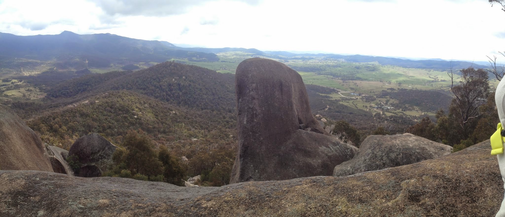
Back at the bench we regained the track to the top. It contours for a while, then climbs via another series of zig-zags. At one point there is a lovely hand rail to give an assist up a sloped rock. Just after that is a great lookout – fabulous views down to Mt Eliza and across to the Tidbinbilla Range. A large patch of grevillea coming in to yellow flower below. A couple of hundred metres later the track pops out at the familiar (to me) saddle with the Gibraltar Peak signage. We made the last climb up the lovely stone staircases to the tors at the top.
Again, new tracks take you up past the place where you used to have to get a run up to scramble up the big granite slab. You come out at the top of it and it’s a simple step up to magnificent views from above the back of the main tor! Stunning!!
Here we found our 3 companions and whilst the rest of our Eliza party had morning tea, ChifleyGrrrl and I tried to find GC13WCY Rock of Gibraltar. We scrabbled about with my GPSr flicking all over the place. I even monkeyed up to the crack shown in the spoiler picture (tonight I read the fine print which says “View FROM the cache”. No joy.
Returning to the others, I realised it was time to move to prevent the dreaded boredom setting in. But thank you for the yummy chocolate brownie that quickly disappeared.
We returned to the saddle area and I snapped a pic so the earth cache GC1H9MC Gibraltar Rocks could be logged.
Back down to Eliza saddle where one of our party decided to head for home – not through boredom but because of other commitments.
We continued down the (new) track, which descends the gullies down the SE and E sides of Mt Eliza. Just off the track, some of us headed bush towards GC3WB8Y Agent Basil Rocks.
Now this little feature is why I was attracted to geocaching – to take me interesting places I didn’t know about. Agent Basil Rocks are the most fabulous wall of vertically stacked boulders. Very easy access up the side and, once on the top, you wouldn’t know there was a 10+m drop. Obviously others know – there were a couple of rock climbing anchor points. However, again no luck in finding the cache.
Back on the track a little later we made a small detour to log GC3YQ11 Basil’s Tidbinbilla Teaser. Thanks for finding it Eric – you really ARE a geocacher!
No joy in finding GC43KQN Birrigai Bridge. Marmaduke Rothschild had warned me it was hard.
We left the track and headed up the knoll towards the next cache. A huge wall of blackberries had to be circumnavigated as we headed towards lunch. It was 1.20pm and I learned later that there was mumblings about lunch in the ranks.
Stephen and Eric scaled the boulder and threw down the metal spike at waypoint 1 of GC3XAK1 Birrigai Boulders. Spat on, it revealed its digits. Thrown back up to be replaced. Lunch.
As always, caching fever wanes in the arvo. So we headed to the final GZ for the last cache (my published track has been truncated to preserve its location – boy, is my caching etiquette improving), then hot-footed it across the open country and a bit of the Birrigai Time Trail to the Tidbinbilla Visitors Centre. 2.15pm.
Organised as ever, ChifleyGrrrl had left her car at there. The kind Ranger let her through the gate (as her TNR pass was at home) and she drove two of us to pick up our cars.
Great company, thanks folks. The last of my TNR caching … until next time.
Party
9 walkers – Eric G, Stephen and Lisa M, Jenny M-B, Lyndall M-B, Alison N, Karen R, Ralph Y, me.