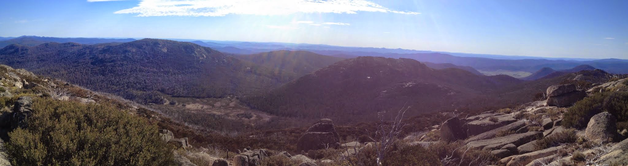
View NE from Mt Kelly – Namadgi, Rotten Swamp, Burbidge, Gudgenby grasslands, Yankee Hats
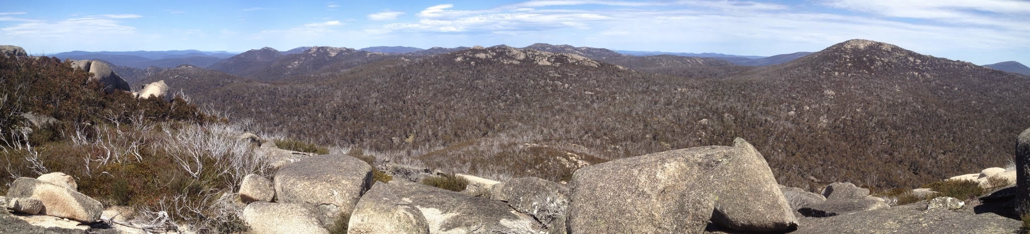
Yankee Hat Ridge to SH1733 with Mt Gudgenby and The Fortress at the back from Mt Burbidge
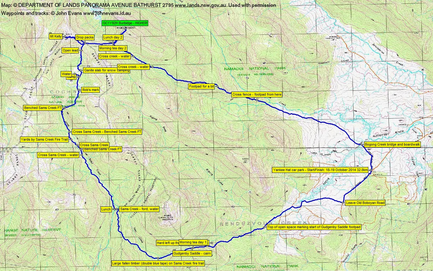
Saturday-Sunday 18-19 October: Weekends in the southern Namadgi #8 Mts Kelly & Burbidge – M/R. Day 1: Bogong, Naas Creek then top end of Sams Creek. Day 2: early morning climb, Burbidge as a short side trip from Bogong Gap then down Burbidge spur. Maps: Rendezvous Creek, Yaouk. Leaders: Jenny & Rob H. Transport: ∼$40 per car.
5 of us drove in 2 cars to the Yankee Hat car park.
Further Information
Look for geocaches on Mt Burbidge.
Summary
Distance: 32.8km | Climb: 1260m | Time: 2 days (8.45am-4.20pm; 7.00am-6.30pm) | Grading: L/R; H(13)
Track Maps
Track overview
Track 1

Track 2
Track 3
Track 4
Track 5
Track 6
Photographs
Photographs are available, where you can start a large sized slide show.
Video
Google Earth
Download the Google Earth .kmz file here.
Track Notes
A masterclass in navigation and route finding from Rob H!
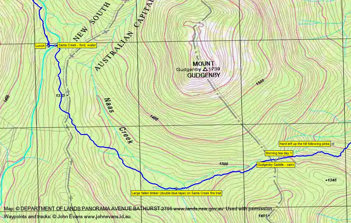
Away at 8.45am and an uneventful leg to the SE Gudgenby saddle, except that we got off the footpad for a while climbing to the saddle (no doubt due to me mistaking a little cairn). A few recently added red bow tapes. 6.8km in 2hrs 5mins.
The next leg was down to cross the Naas Creek and join Sams Creek Fire Trail (at the large fallen timber where the double blue tapes used to be), then south and west around Mt Gudgenby to cross Sams Creek and stop in the black sallee grove for lunch. The new red bow tapes continued for a while around the SW of Gudgenby. 3.7km in 1hr 20mins.
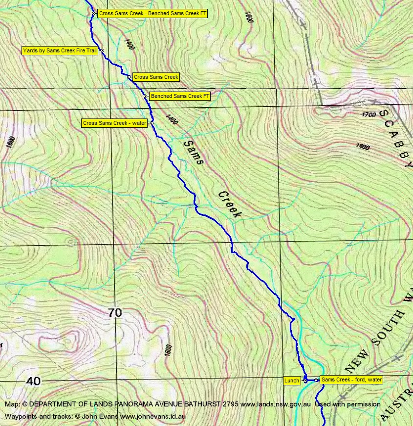
I was interested to see where Rob exited this area, as last time coming in to it from the north, we came in high and I’d marked some waypoints on the clear Sams Creek FT alignment. We left via the obvious footpad near to the fireplace where we’d lunched, hitting most of the waypoints at recognisable portions of Sams Creek FT that I have. A great run up the creek, crossing to the true left side to pick up more benched FT, then back to the true right side and so to the yards site. From there we continued north for another 500m, then crossed to the true left side for the last time, picking up obvious FT benching immediately after crossing Sams Creek. From lunch to this last crossing was 3.5km in 1hr 35mins.
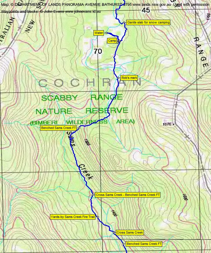
The final leg of the day was an excellent route, a little new to me. We used benched FT in places, footpad in others, passed a small stone cairn and came out on the top flats at a granite slab which Rob uses as a map point. Squelched across the lats to camp near SH1537. 2.5km in 1hr 30mins.
A nice camp site, water ∼200m away. After our meals, delicious rocky road made by Jen, washed down with a drop of port. A mild night (accompanied by mild snoring from the nearby tent) – don’t know if I’m an offender too.
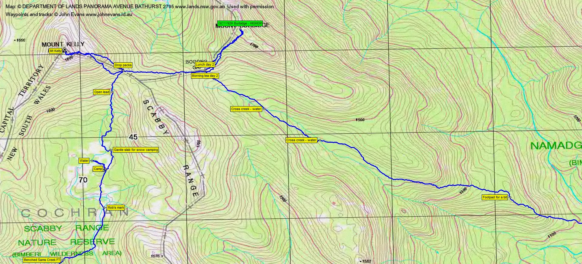
Up at 5.45am and away at 7am. Tracked north to Kelly saddle, passing a granite slab that Rob said is useful for camping in the snow. Pretty slow and scrubby after leaving the flats, until a mercifully open lead helped us to the saddle. 1.5km in 1hr.
We dropped our packs, took the necessities in day packs and climbed Mt Kelly. The route a little to the north to what I’m used to, but it’s all scrubby until you break out onto the granite slabs. Ascent was 0.77km in 45mins.
As always, astounding views. Check out the photos and video. Tweeted a pic. Was going to ring @alison_chifley and the FARCM ladies on Gingera, but didn’t bring her number and it was probably too early.
Descent was 0.8km in 35mins, the poor track solely my fault as I had the waypoint of the packs and was out front.
We regrouped and regathered (I use the same pack for side trips, so need to unpack and repack). Rob led an unerringly straight course across to just above Bogong Gap where we had morning tea. 0.8km in 25mins.
Next we climbed Burbidge with day packs as a side trip. Last time I used this route was 9-11 Dec 06 and the trip took 30mins. Today it took 50mins. Yes, bodies are a few years older, but the regrowth is too. Nice aiming granite feature around half way up, go on the right of it when ascending and left of it when descending.
Huge views again, especially across to the 4km of the border along the SE Scabby Range that I’ve yet to do. Check out the photos and video. A tweet of Kelly from Burbidge. A couple of us went to look for the geocache GC1Y92H Burbidge – HIGHER! Thank goodness for the spoiler photo – it would be a hard find in amongst all the granite without it. Only the second party to visit this cache, since it was hidden on 12 Sep 09. I wonder why! No time to search for the other two Burbidge caches.
Descent was 50mins. Again, I had the pack homing waypoint and, again, muffed the bottom of the route to them. Lunch.
We left at 1.10pm. Some relatively easy going over snow grass on the route to the top of the south arm of Middle Creek, then some horrendous scrub and shrubs, then some spongy sphagnum creek flats. Huge views to the great granite dome that sticks out the SW side of Burbidge. Crossed to the true right side, then ∼600m later crossed back. Plenty of ants as we watered up. Some relatively easy and open walking as we sidled the Burbidge Spur around 200m after the second creek crossing, but it didn’t last long. Coming round towards the nose of the spur at the 1380m contour we ran into pickup sticks and tight scrub. A very little easier on the crest of the spur from 1300m contour (even a bit of a footpad in one place), but hard and slow going through all the regrowth. Actually, quite disappointing when compared with my memories of this spur.
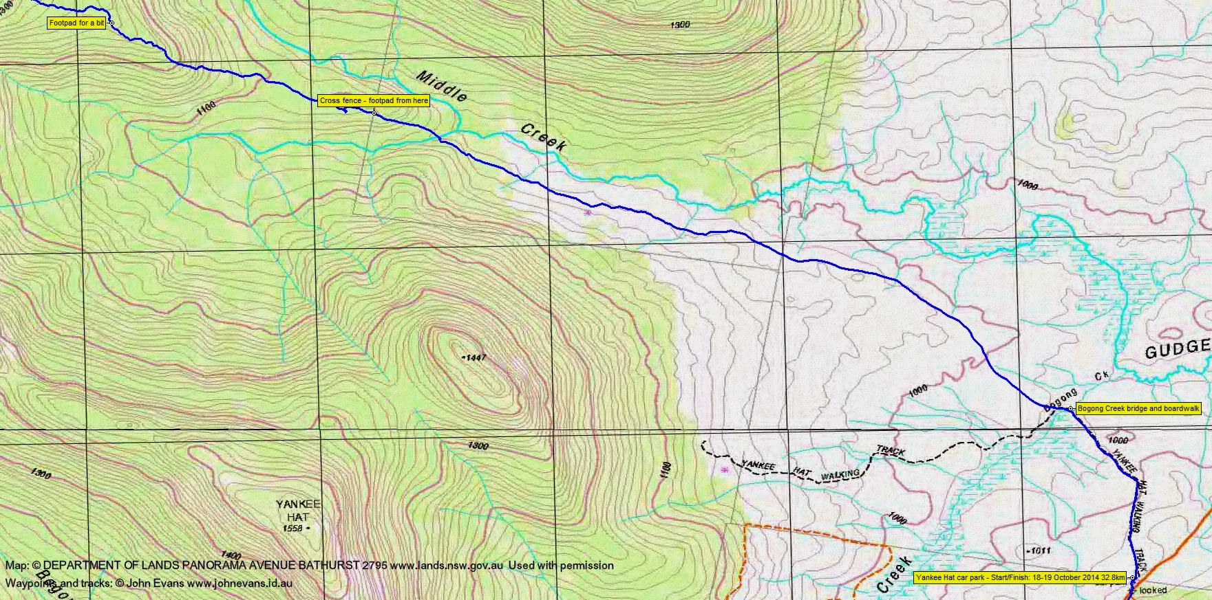
At last we crossed the fence line and a footpad took us all the way home. Crossed the south arm of Middle Creek at 5.20pm. Back to the cars at 6.30pm. The exit from Bogong Gap was 9.9km in 5hrs 15mins.
A tough, but very satisfying trip. Thanks Rob and Jen. Definitive track for Sams Creek FT.
Party
5 walkers – Rob and Jenny H (leaders), Stephen M, Robert M, me.