Walking the tops above Coolumburra Creek south of morning tea
Tuesday 28 October: Upper Coolumburra Creek M/R/part X. A circuit in Morton National park, all off-track. From Rolfes Gap (376E 149N AGD 1966) head East, initially around the base of the cliff-line past a camping cave then up a straightforward pass at 389E 150N. North east along a rock slab balcony, then find a pass to descend to explore the upper tributaries of Coolumburra Creek. Return via the tops to Pagoda Pass at 385E 143N followed by more cliff-top views. Spring flowers, rough but scenic terrain, scrub ranging from light to thick, some rock scrambling. Probably 5-6 hours actual walking, 10 km and 250 metres of climbing – unless we decide to expand the circuit. 1 hr 45 min drive from Queanbeyan. Map: Nerriga. Leader: Linda G. Transport: $80 per car. Limit: 8.
11 of us drove in 3 cars via Bungendore, Tarago, Oallen Ford and Nerriga. After crossing the Edrick River, we turned off onto a fire trail and drove up to park at Rolfes Gap.
Summary
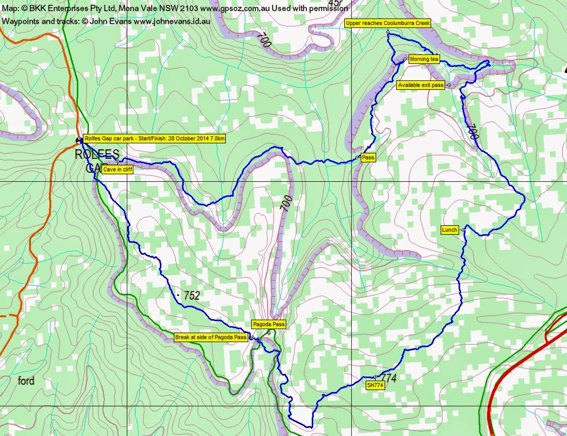
Distance: 7.8km | Climb: 300m | Time: 8.50am-2.35pm (5hrs 45mins), with 70 mins of breaks | Grading: S/R; M(10)
Track Map
Track
Photographs
Photographs are available, where you can start a large sized slide show.
Google Earth
Download the Google Earth .kmz file here.
Track Notes
Within 4 minutes of the cars we were at a cliff line, following it around to the east past a large cave suitable for camping. Easy walking and scrambling around the base of the cliffs, not overly high but most scenic. We crossed a wide gully and scrambled up a pass to the tops. Great views off to the west as we ambled through a great display of spring wildflowers to morning tea.
After our break we descended through an unmarked, narrow and slightly steeper pass to the upper reaches of the Coolumburra Creek. A nice rock hop and wander up the creek, eventually leaving it via another gentle pass.
We followed a side creek up along the bottom of yet another cliff line. Lovely red lichen on the sandstone in places. Eventually up onto the tops and a slightly more scrubby leg to lunch. A generous, un-Tuesday like time allowed.
The next leg took us south then south-west to the barely perceived SH774, then to the top of the cliff line above Willies Creek. Great views! We could also see the trucks crawling up the Nerriga Road to Bulee Gap.
Turning north-west, we walked along the cliff tops and descended into Pagoda Pass. We sort of crossed the southern part of it. Sandstone pagodas there were.
Continuing north-west, we walked the tops through SH752 and finally descended a gentle part of the cliff line and so down to the cars.
Short, but very sweet! Lovely sandstone cliffs and pagodas, a ferny creek. Views and wildflowers galore. Great walk in an area seldom visited by me. Thanks Linda.
A drink at the Nerriga pub on the way home.
Party
11 walkers – Mark B, Peter C, Eric G, Linda G (leader), Ian H, Jenny H, Stewart J, David O, Max S, Ian W, me.
Next Tuesday Walk
Tuesday 4 November: Sassafras Mountain M/M,ptX. Starting at the usual Nerriga entrance to the Budawangs off Meangora Rd, we will proceed along the walking track to cross the Endrick river and follow Redgrounds Track to approximately where the track turns south. From there it will be off track to find a path up to the top of Sassfras Mountain. Head toward Gilberts Gap to locate a path down to the valley and return. The bush at the top of Sassafras is very scrubby – all slow going. This is an exploratory walk for the leader. Approx 8 .5 km on track and 4.5 km off track. Map: Endrick. Depart Spotlight at Queanbeyan 7.30am. Possible late return. Please register interest (maximum 8) with Max S.