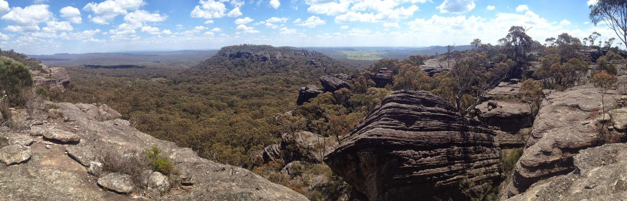
SH772 from near the top of the descent pass
Tuesday 4 November: Sassafras Mountain M/M,ptX. Starting at the usual Nerriga entrance to the Budawangs off Meangora Rd, we will proceed along the walking track to cross the Endrick river and follow Redgrounds Track to approximately where the track turns south. From there it will be off track to find a path up to the top of Sassfras Mountain. Head toward Gilberts Gap to locate a path down to the valley and return. The bush at the top of Sassafras is very scrubby – all slow going. This is an exploratory walk for the leader. Approx 8 .5 km on track and 4.5 km off track. Map: Endrick. Depart Spotlight at Queanbeyan 7.30am. Possible late return. Please register interest (maximum 8) with Max S.
7 of us drove in 2 cars to the Nerriga entrance to the Morton National Park.
Summary
Distance: 13.7km | Climb: 380m | Time: 8.40am-2.50pm (6hrs 10mins), with 40 mins of breaks and lots of looking time | Grading: M/M-R; M(11)
Track Map
Photographs
Photographs are available, where you can start a large sized slide show.
Google Earth
Download the Google Earth .kmz file here.
Track Notes
A pleasure to be driven – I slept all the way there and half the way back. A lovely Spring walking day, maybe mid-twenties.
Max had down-played this walk after last Tuesday’s, but it was every bit as good! Excellent cliff lines, passes and views. Wildflowers in abundance.
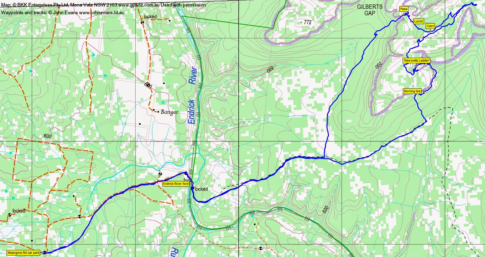
A trot in from the Nerriga (Meangora Rd) entrance to the NP, which is a fenced right of way through private property, to splash across the shallow Endrick River and gain the Park. 1.9km in 25mins.
Then a jaunt along the Redgrounds Track, nearly to where it turns sharply to the South. 2.6km in 40mins.
Here Max turned us into the thick scrub, which only relented as we neared the base of the cliff line. Immediately spectacular as we hit the line at a monstrous overhang. Turning right, we wandered along the bottom of the cliffs for a hundred metres or so, then stopped for morning tea. 0.5km in 25mins.
We continued our skirting around the bottom of the cliffs. Huge overhangs, caves and walls. We headed into a triangular shaped set of cliffs and ascended a truly excellent narrow slot that we named ‘Maxwells Ladder’, in honour of our esteemed leader. Reaching the tops, we walked a little way to the East to admire the huge views. This leg 0.7km in 30mins.
Returning to the top of the pass, we went West, then took a line generally NE along the tops. Alternating open rock slabs and scrub, lovely flowers, moderately easy going. We continued until we’d had enough, then returned to the SW, spotted a marker cairn (which had to mark something, but we weren’t sure what), and turned NW to stop at a lunch spot with huge views across to the ‘island’ of SH772 across the other side of Gilberts Gap. This leg 2.5km in 1hr 30mins.
Max knew of a pass near the lunch location which would take us down. We left at 1pm and descended with little fuss, arriving at the bottom 15mins later.
We then tracked generally SW through light-medium scrub to rejoin the Redgrounds Track. This leg from lunch 2km in 1hr.
A potter back to the cars, arriving at 2.50pm.
A stop at the Nerriga pub on the way out. I knew there was a geocache thereabouts, but didn’t bring its location as I thought surely this fine upstanding crew would not make such a visit the second week in a row. Just goes to show – you never know your friends!
An excellent walk, thanks Max.
Party
7 walkers – Peter C, Chris F, Eric G, Linda G, Stewart J, Max S (leader), me.
Next Tuesday Walk
Tuesday 11 November: Northern Section of Tallaganda National Park – L/R/X. The walk starts at the junction of the Forbes Creek road and North Black Range fire trail. The walk is mainly off-track in the northern section of Tallaganda National Park. We will visit South Black Range Trig, then take a long meandering route northeast then southwest, through forests, swamps and undulating ridge country back to the cars. This is a long exploratory trip for strong walkers and it could be difficult going in places. Minimum distance: 18 km with ∼600 metres of ascent. Map: Bombay. Leader: Ian W. Transport: 106 km return. Limit: 8.