Ettrema Creek

Tuesday 2 December: Ettrema in a day – M/R/W. A circuit from the Jumps (391E 201N AGD 1966), down Bullfrog creek to Ettrema Gorge (417E 193N) then back up the next side creek (419E 207N, to 406E 204N). Cascades, crystal clear pools, some rainforest, some scrub, one camping cave, and lots of rock-hopping. No compulsory swims but some optional ones and one wade. About 11 km, 350 m of descent and ascent, 7 to 8 hours actual walking. A 1 hour 50 minute drive from Queanbeyan. Map: Nerriga. Leader: Linda G. Transport: $100 per car. Limit: 8. Late bookings considered.
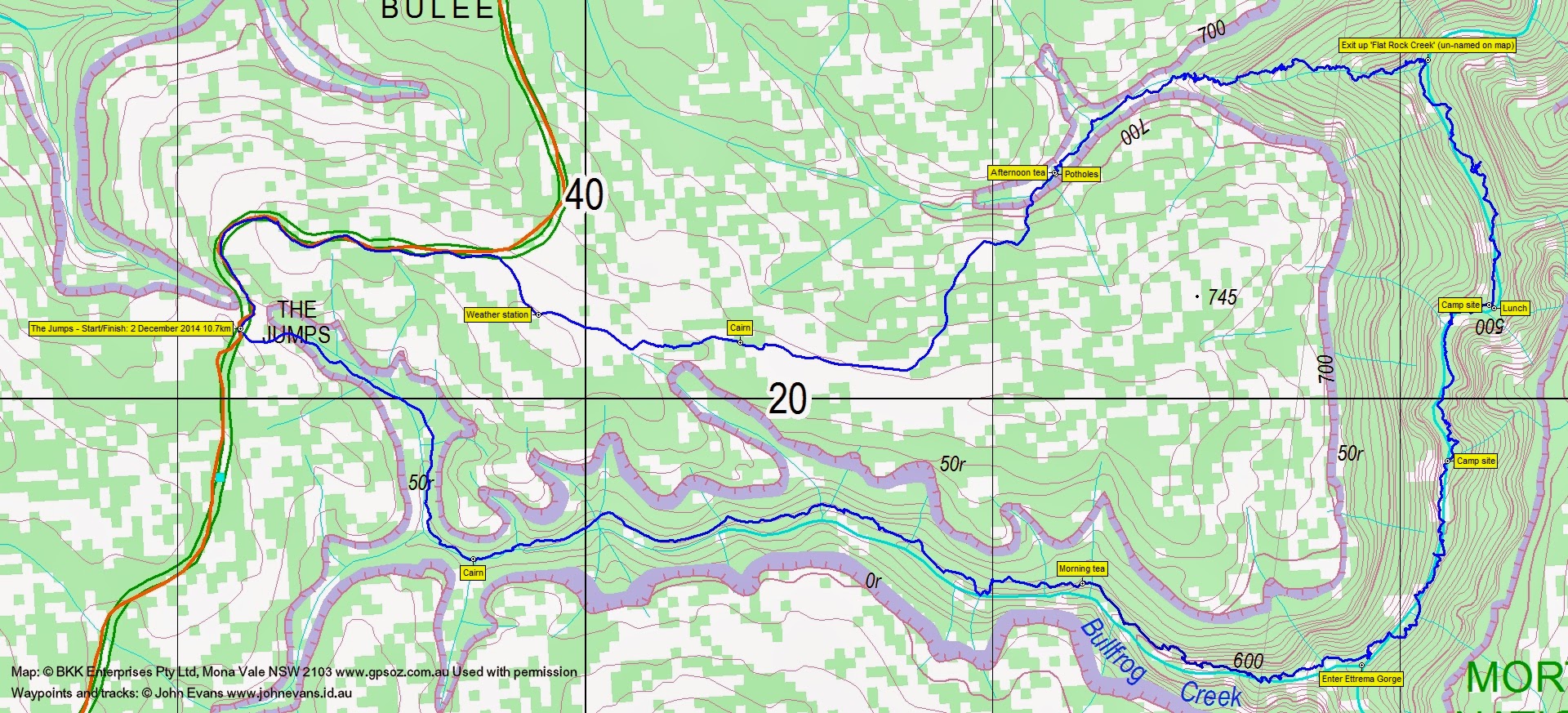
8 of us drove in 2 cars via Nerriga then off the Nerriga Road along Tolwong Rd to park at ‘The Jumps’.
Summary
Distance: 10.7km | Climb: 380m | Time: 9.00am-4.40pm (7hrs 40mins), with 1 hour 20 mins of breaks | Grading: M/R,W; M(11+)
Track Map
Track
Track

Photographs
Photographs are available, where you can start a large sized slideshow.
gpx File
Download the .gpx file here. (Right click, Save Link As…, Save – if you want to use it.)
Track Notes
You wouldn’t have wanted to be dead for quids today. Linda put on an absolutely fabulous walk, which certainly practised some techniques which needed practising for me. Hard to grade the walk via the BBC system – it should probably be a H(13).
A day requiring concentration from me, as most steps had the potential for a slip or a fall … into that dreaded water (for me; others reveled in it!). I was pleased with my log walking efforts and felt comfortable just watching the tree trunk in front of me rather than worrying about the consequences of a slip. Certainly not up to the standard of the others though. Not pleased with my dislike of water. I managed a chest high wade, but in other places Madam leader kindly led me round the narrow ledge which allowed me to escape full immersion. I’m sure she would have rather been swimming the pools with the water boys.
The photos aren’t very spectacular because, in the spectacular places, my phone was in a dry bag in the top of my pack! At one stage I was wondering why David W wasn’t too concerned about his camera – later he put it underwater to take a photo of an eel.
What can one say? From the start, pretty much straight into the top of Bullfrog Creek. A gentle gradient at first, dropping away more steeply as it neared the confluence with Ettrema Creek. Most of us tried to remain dry-footed by rock hopping, but eventually the time came to wander down the creek bed and through the pools. A good flow of water in Ettrema Creek where we joined it under towering cliffs.
The Ettrema Gorge leg to lunch was the most testing for me (so I thought at the time), including the deep wade. But a truly lovely creek. Last time I was in Ettrema was 19 Jan 10 when we went in south of Churinga Head and exited via Myall Creek.
A difference of opinion at lunch time, with our leader remembering no further wades, but her consort remembering more wades. Unfortunately for me, Peter was correct.
Eventually reached the unnamed exit creek (on the map, but possibly called ‘Flat Rock Creek’ – not that there are any flat rocks until one exits the very top of the creek). After a brief pause, we began the 250m climb out. Nearly immediately there was a climb up a rock wall and I enjoyed a little slip at the bottom. Good to be reminded to be careful. A slow exit, particularly up a patch of scree. No breeze and much humidity as the thunder rolled overhead. The exit was certainly more difficult than the entry and I’m glad Madam leader had enough confidence in me to accept me on the walk – I wouldn’t have! And I’m also glad she didn’t tell me about the exit earlier in the day!! We were encouraged, however, by the tale of Madam leader and good husband bringing 7 year old children on the exact walk many years ago.
Made the ‘potholes’ and stopped for arvo tea and to pick up a little water. Warnings of scrub to come but, thankfully, there has been a burn (controlled?) that cleared the area out and the walk back to the road was relatively painless.
A stop at the Nerriga pub on the way home. Extraordinary good fortune – the camera lost on 4 Nov 14 and searched for by said owner a few days later had been found and handed in to the pub. Photos had been examined, Canberra registered cars and bushwalking photos seen. 2+2=4 and an email was sent to the CBC president.
What a great day. Thanks Linda! Makes next Tuesday look a bit pedestrian.
Party
8 walkers – Peter C, Eric G, Linda G (leader), David O, David P, David W, Ian W, me.
Next Tuesday Walk
Tuesday 9 December: Yankee Hat North and Middle Creek – M/R,ptX. Yankee Hat rock art, up Yankee Hat North for geocache GC33R07 Oh My Hat!. Saddle, then down NW and up Middle Creek a way to geocache GC26Y22 Dinner Rock. Return true left Middle Creek and Gudgenby grasslands. Around 15km and 600m climb. Maps: Rendezvous Creek and Yaouk. Leader: John Evans 0417 436 877 john@johnevans.id.au . Transport: $12.