This walk was organised and led by Chris L as a CBC walk:
(' Saturday 25 February – Upper Ginini Falls – S/M These falls are in the cool high wetlands of the Brindabellas near Mt Ginini. The walk is short and through snow gum bushland and on the edges of peat lands. I would also like to explore a little bit beyond the falls. I wonder if we may see any little black and yellow frogs? Map: Corin Dam 1:25000 Leader: Chris L Transport: ~$17'). 11 of us met on the outskirts of Duffy and drove, via the Cotter Bridge and Piccadilly Circus, as far as allowed down the Mount Franklin Road. One and a half hours takes you to the car park below Mt Ginini. |
This was a lovely little cameo walk, short and sweet with something for everyone. Snow gums and sub-alpine grasses, waterfalls, plenty of down - and up, sphagnum areas in alpine flats and many non bushfire affected areas.
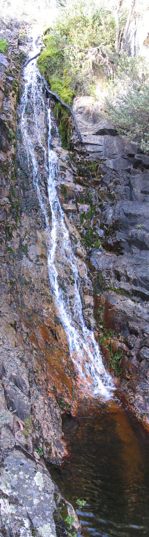
We set off back up the road at 9.05am, the cooling effect of the height we were at, obvious. A couple of hundred metres along we turned N into the trees and followed the well defined spur down through the woodland neck at the NW corner of Ginini Flats. Very pleasant with soft grasses underfoot and unburned trees. After passing an unnamed little flat to our W, the spur dropped some more past a first set of cascades, then down to Upper Ginini Falls, just 50 minutes and 1.5km from our cars. A drop of 150m.
The first edition map shows a 60m relative drop at the falls and we were able to safely scramble about half way down to a pool which afforded views back up the top half of the falls and a glimpse over the outlet for the final splash. Refreshing sounds, and sights up and across to Mt Franklin.
There was no way further down this close to the creek, so we retraced our way past the resident snake, turned W and across the feeding creek of those first cascades, then down (175m in 0.5km) another spur through tall and straight Mountain Ash to cross Ginini Creek at the top of a pretty little 'morning tea' falls.
Setting off again at 11.20am, we knew that up had to follow down, so plugged up 200m to a shaded lunch spot catching a nice breeze.
Away again at 12.45pm, we crested a rise onto an open area above Ginini Flats which afforded a vista of much of our outward leg from Mt Ginini down to the cut in Ginini Creek. Down and out onto Ginini Flats. They were a little dry, but the sphagnum was still wet and slowly leaking water to feed the creek, the falls and, eventually, via Stockyard Creek, Bendora Dam and the Cotter River, out our taps. No little black and yellow frogs to be sighted, but some late wild flowers (including alpine gentians) and a mountain grasshopper which looked like a dull Christmas beetle on junk food. He didn't hop much.
Across the flats and up the cleared old ski run to the cars, reaching them at 1.50pm.
Most of us strolled up the ski run and access road to the top of Mt Ginini, so I could bag the 7th highest peak in the ACT at 1762m. Unfortunately the high point is inside the fenced off communications facility! Excellent views. South down another ski run to Little Ginini (which I haven't bagged yet!) with Mt Gingera at its rear. Returning down the road, the Tidbinbilla skyline from Mt Domain to Mt Tidbinbilla sits imposingly behind Mt Franklin, with the Captain Cook memorial jet and other parts of Canberra sighted. To the E of south, there are fabulous views down to Mt Burbidge and its other wild mates in the heart of NNP. Oh to get up some more of those!
Back to the cars again at 2.20pm and a dusty trip home. We should add a car wash surcharge to transport moneys!
Thanks Chris and others. An excellent little round with plenty to see. Going back next Wednesday with Max S to continue down the creek to the main Ginini Falls.
Distance: 5.8km Climb: 475m. Time: 9.05am - 2.20pm (5.25 hours) with 1 hour of stops.