| Further Information
The walk will be from Round Mountain car park, across Tumut River, along Farm Ridge track to Grey Mare FT. Camp somewhere around O’Keefe’s Hut. Climb Jagungal Wed, down to upper Tumut river and back along Round Mountain FT. There may be side trip if time allows. I think about 20 km/day and some up and down.
Photographs
Access all pics here. All thumbnails in the walk report are active - click for a larger picture.
Walk
 |
 |
 |
 |
 |
| track a |
track b |
track c |
track d |
track e |
 |
 |
 |
 |
| track f |
track g |
track h |
track i |
Our walking companion, Tom, turned out to be born with boots on, young, fit and the current President of the ANUMC! A high class companion for two old blokes.
Day 1
| Max said he'd take me to Mt Jagungal, but I had no idea he meant door-to-door. It was wonderful to be chauffeured in the big V8 and chat with Tom to find out what's happening via ANUMC. From Duffy to the Round Mountain Track Head via Cooma and Kiandra was 3hrs (6.10-9.00am). A little overcast in places over the hills on the way, but broken cloud and sun at the track head. Plenty of cars and walkers for a Tuesday. |
 |
| Round Mountain Track Head - busy on a Tuesday |
|
| We set off along the Round Mountain fire trail, all new territory for me. Cool at first and I wondered whether I had appropriate gear for the cool night. After 1.5km we turned left onto the Farm Ridge fire trail and soon came across Round Mountain Hut. A quick look inside and we went on. |
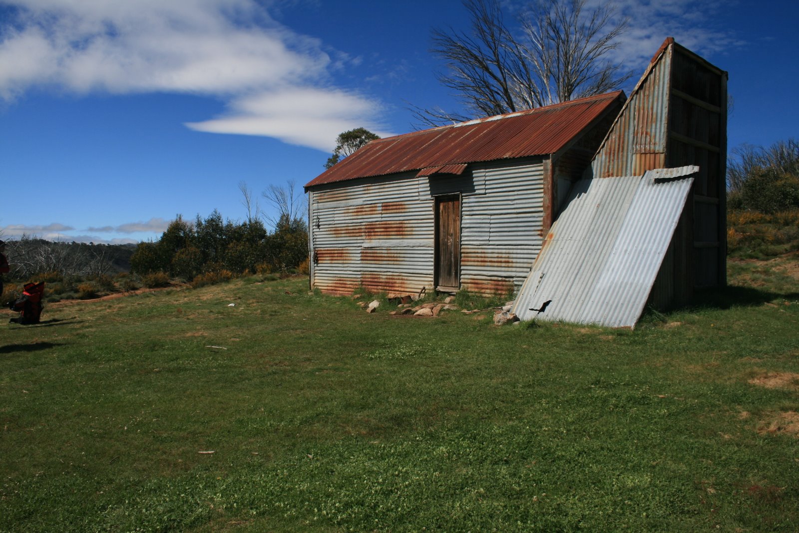 |
| 1 Round Mountain Hut |
|
| The track continued a further 1.9km down to the Tumut River. A lovely rolling view down to the river sparkling in the sun. |
 |
 |
| Down the Round Mountain fire trail to the Tumut River |
2 Tumut River from the Round Mountain fire trail |
| Not being one for bare foot river crossings I waded across boots and all and suffered the consequences of damp feet for the remainder of the day. Max and Tom were more elegant, de-booting and crossing, then drying and re-shoeing. From the SE bank of the river we could see a large party of walkers climbing the footpad (the 'fire trail' had deteriorated to such) up onto Farm Ridge. |
 |
| Fording the Tumut River |
|
| From the ford the track climbed 300m over 3.4km to morning tea on Farm Ridge. We passed a large group of students and teachers from a nearby high school. They were going to camp at O'Keefes Hut, so that fact added some substance to Max's flexible plans - we would not. A wonderful snow gum and grassed ridge, affording grand and ever closer views to our primary objective. |
 |
 |
| Mt Jagungal from Farm Ridge at morning tea |
3 Mt Jagungal from Farm Ridge |
| Having enjoyed out morning tea break, the track/footpad took us a further 4.7km in 57mins (so easy walking) towards the junction with the Grey Mare fire trail, part of the famed AAWT that several of my friends have walked. Mt Jagungal loomed closer. |
 |
| Mt Jagungal from near the junction of the Farm Ridge ft and Grey Mare ft |
|
| At the well sign posted junction, Max took us a few tens of metres to the E to a hut site. An obvious stockyard on the opposite side of the fire trail and, just a bit up and into the trees, a lovely bit of fencing. |
 |
 |
| Hut site near the junction of the Farm Ridge ft and Grey Mare ft - marked as ruin on 1st edn Khancoban 1-25000 |
4 Nearby stockyard fencing |
| Next came 3km (in 50mins so continued easy walking) along the Grey Mare ft. A lot of the area is burnt and grey with dead standing timber. Mt Jagungal closer still. Pretty flowers galore - wish I knew the names. |
 |
 |
| Mt Jagungal from the Grey Mare ft |
Flowers |
| O'Keefes Hut provided a very pleasant spot for lunch. The rebuilt hut is very well done inside, with old newspapers plastered over the inside walls and lovely furniture. And a fine collection of chairs, which suited us very well when taken outside and placed along the lee wall in the sun. A well spent 40mins. |
 |
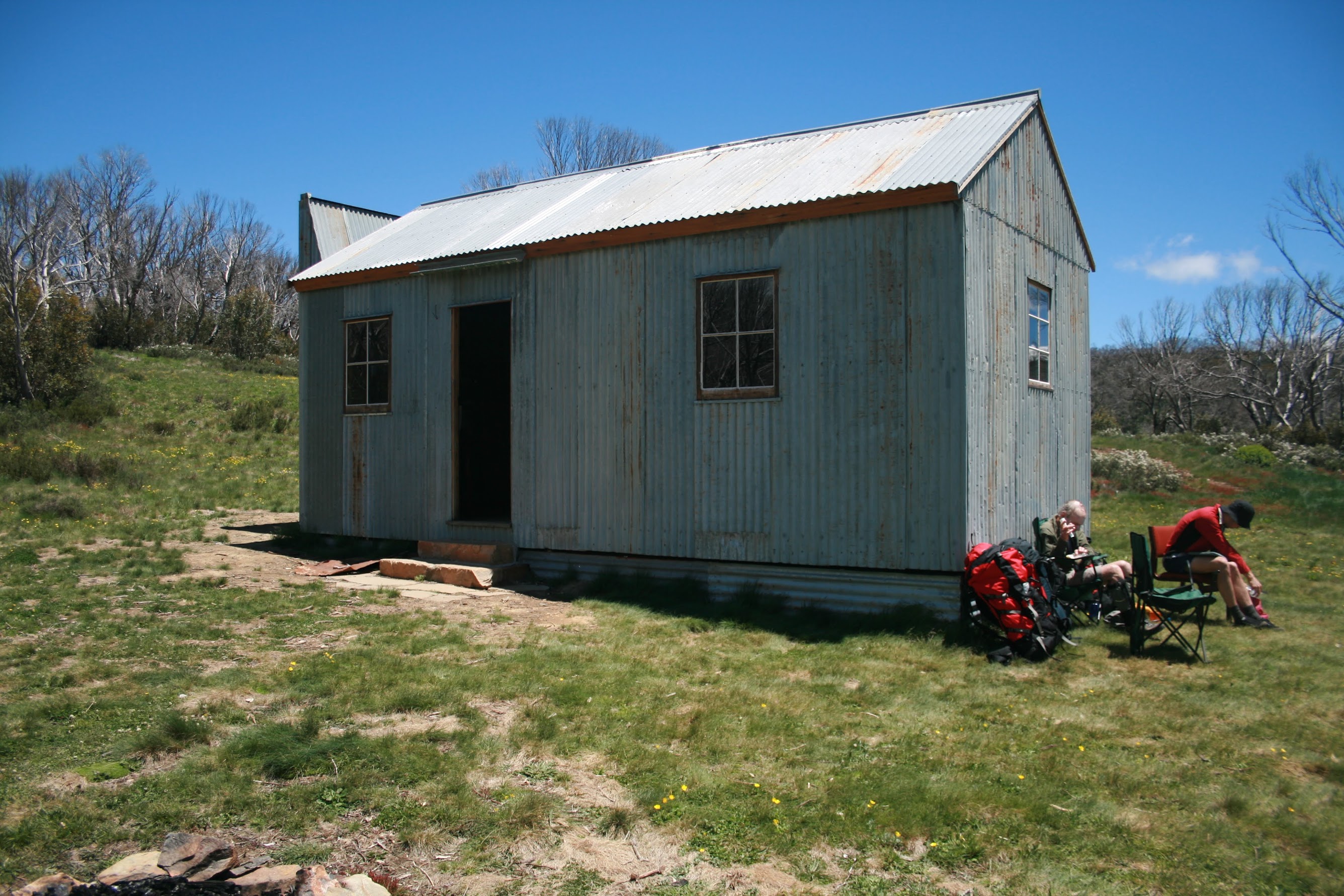 |
| Interior of O'Keefes Hut |
O'Keefes Hut |
Back on the track after lunch, 2km brought us to the meteorological station and the DFIR. The signage says:
You are looking at a Double Fence Inter-comparison Reference (DFIR), also known as a Wind Fence.
The DFIR design is based on the World Meteorological Organization standard. The structure that you see here has been reduced in size from the standard design to minimise impact on the environment.
The purpose of the DFIR is to improve the accuracy of snowfall measurements by the precipitation gauge (located at the centre of the structure).
In locations such as this, accurate measurement can be difficult - especially at higher wind speeds - as a large proportion of the snow can be blown over the top of the gauge and not measured.
The two concentric fences of the DFIR reduce the wind speed at the opening of the gauge, significantly reducing the measurement error.
These structures have been placed at key locations across the Snowy Mountains, and the measurements are used predominantly to gauge the effectiveness of the cloud seeding trial. The structure will also provide rainfall information for park management at other times of the year.
The data collected at this site is used for scientific research by Snowy Hydro Limited, and the NSW Department of Environment and Climate Change.
|
 |
| DFIR |
|
| At this point Mt Jagungal loomed above us. |
 |
| Mt Jagungal from near the met station |
|
| From here we began the 400m climb to the top, passing through relatively open scrub and up into the open sub-alpine going to eventually gain above the tree-line. A lovely view opened up behind us and the old boys took many opportunities to appreciate it as we stopped to regain our breath. The climb arced us around the NE flank of the mountain and the view across to the neighbouring ridge was most pleasant. |
 |
| View down our climb to Mt Jagungal and our way in from Round Mountain |
|
 |
| View across to another ridge from nearer to Mt Jagungal |
|
| We dropped our packs at a likely camp site in the lee of the summit and scrambled to the top for the huge all-round views. To the S, over the S knoll of the top, Tom pointed out the recognisable tops of the Main Range, including Mt Kosciuszko. Some drifts of dirty snow remained. Nearby to the SW the Tooma River drained away and, to the NW, the Tumut River. We could see the Round Mountain fire trail that we'd tread tomorrow wending across the alpine meadows. To the N, over the N knoll of the top, I could identify Round Mountain (near where we started) - a possible objective for tomorrow. Other hills and dales I had no idea of. The view close by to the NE held my attention most of the time we were about this place - a lovely open saddle across to the next ridge falling away down to the Grey Mare ft. The high point of Mt Jagungal is marked by a concrete block cairn, the old one lying in ruin nearby and rusted steel eyelets still firmly embedded in the rock which would have held its guys. |
 |
| View S from Mt Jagungal to Mt Kosciuszko and the Main Range |
|
 |
| View to the N knoll from the Mt Jagungal cairn |
|
| Back down, we set up camp. Tom took all of 2 minutes to unroll his bivvy and give me a demo; Max and I a lot longer to set up our more complicated and heavy tents. |
 |
| Tom's bivvy occupied |
Water was available around 500m down to the NE at the 1890m contour. We had a cuppa, another stroll around the top, a little red plonk and bikkies and 'bert, then cooked tea.
| Donning warmer clothes, we returned to the top to watch the sun go down. Another view to the SE to the rolling alpine areas. To the W the sun glinted on the Tooma River. Our exemplary leader shared around tots of single malt. |
 |
| View SE through S from the Mt Jagungal cairn |
Gas stoves are not conducive to standing around chatting, so we called it a day. I wasn't exactly geared for the cool, having brought no thermals, but down mummy soon warmed up. The tent-rustling breeze died away in the early hours of the morning.
Day 2
| Location, location, location is the catch-cry in real estate. Well, here's the view out my front door and out the back to the next door neighbour. One wouldn't be dead for quids! It was lovely in the still morning sun, above the clouds filling the valleys below. |
 |
 |
 |
| Sunrise on nearby tops from our Mt Jagungal campsite |
Max's home at our Mt Jagungal campsite |
Early morning views from our Mt Jagungal campsite |
| Breakfast over and packed up, I took the opportunity to scurry up to the top another time and head for the N knoll. It sports a star picket marker. Views back along the top to the central knoll with concrete cairn, as well as all round in the freshness of the early morning sun. |
 |
| 5 Mt Jagungal cairn from the N ridge |
| Shouldering packs, we wandered round to the SE flank of the mountain, dropped them, then wandered up to the cairn for a final time and along to the S knoll. Views again to the Main Range, the source of the Geehi River closer, and to some quartz blocks a few hundred metres away to the SE. |
 |
| Source of the Geehi River |
| Down we went to examine them, quite a striking feature. |
 |
| Quartz blocks SE of Mt Jagungal |
| It was time for day 2 to seriously begin. We headed W across the S flank of Mt J, surprising and being surprised by quite a large black snake. Picking up a footpad, we descended 300m via a pleasant spur and drop-off containing remnants of unburnt Snow Gums. The footpad ran down the very source of the Tumut River, crossing it where it comes out onto the Grey Mare fire trail (AAWT). So both approaches to Mt J, from the met station to the N and this one from the SW, are very pleasant. |
 |
| Ford over the Tumut River at the take-off point for the SW approach to Mt Jagungal |
| Heading W on the Grey Mare ft, within a kilometre we came to the junction with the Round Mountain Fire Trail. This is, indeed a fire trail. The area is the watershed of the Tumut (flowing N) and Tooma (flowing S) Rivers. An open alpine plain, it was easy walking today - but would be hot on a Summer's day in the beating sun. We reached Derschkos Hut and met four guys supporting a very large (20+) D of E party. We'd guessed that we'd meet someone, from the busy state of the car park the previous morning and the smoke rising from the hut area which we'd seen the previous evening from Mt J. So both groups we'd met were very large - hardly minimal impact. |
 |
| Derschkos Hut |
| From the hut it was quick walking, 4.3km in 55mins to morning tea, then a further 4.9km in 1hr to Max's next surprise. |
 |
| 6 Round Mountain and the Round Mountain ft from near Pugulistic Creek |
| Setting a bearing, Max marched us 2km through a little scrub and across alpine meadows to find the Cool Plain Hut ruin. A ruin it is. A shady spot under the trees nearby was an excellent place for lunch. |
 |
| Cool Plain Hut ruin |
|
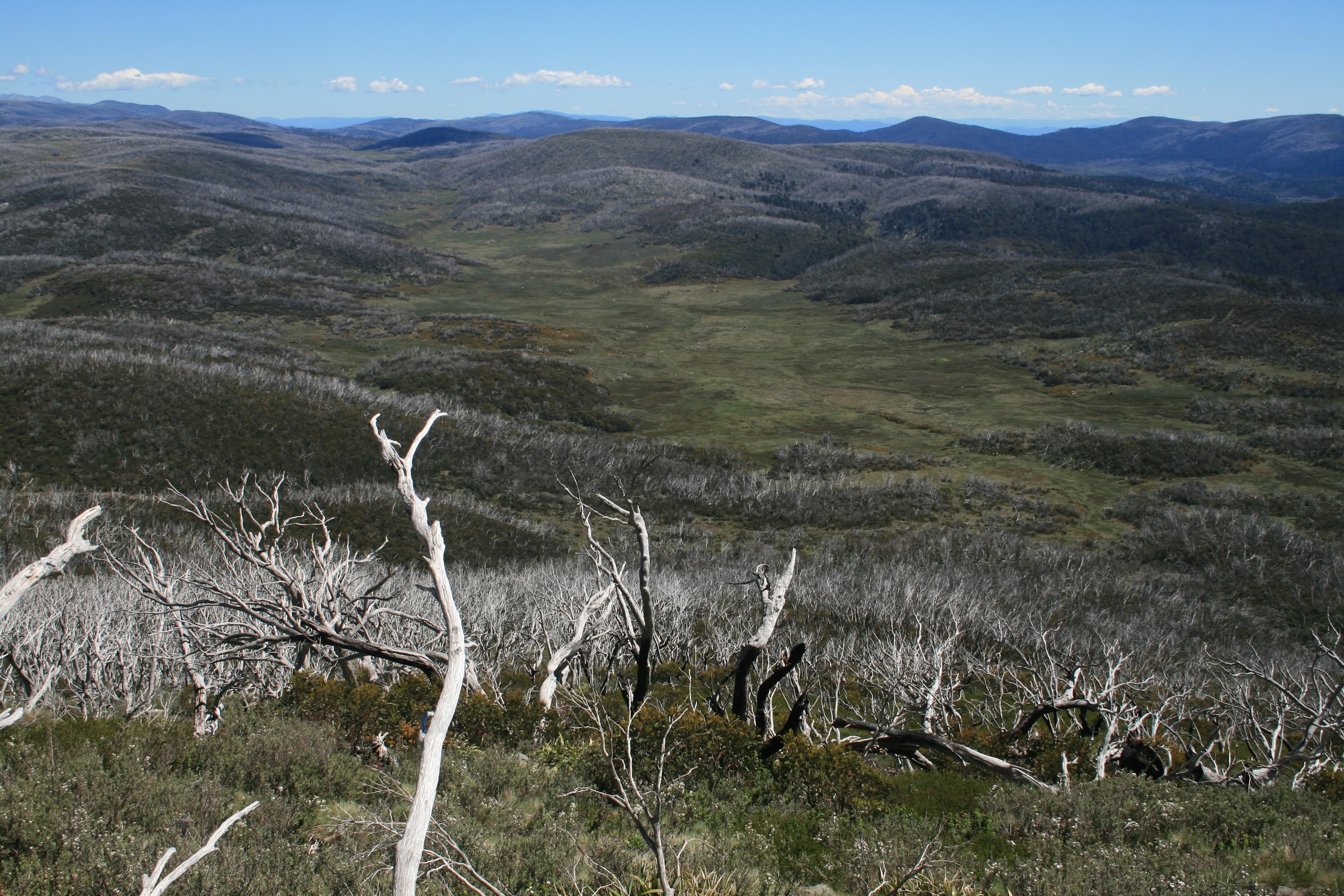
| Our trusty leader's remaining offer was to take a B-line from our luncheon trees to the car. Only Round Mountain stood in the way but, as he explained, there was no extra distance involved. This leg started pleasantly enough, first across the alpine drainage flats from which we could see an open patch on the flank of Round Mountain, then though leads rising through the scrub and regrowth. However the 250m climb soon became unpleasant, with increasing steepness, regrowth and the dreaded 'pick-up-sticks' of fallen timber. But in our 30 hours of knowing Tom we mature gentlemen had gauged his capabilities, so gladly hung back to let him make the going ( = we were buggered). A grand job he did, breaking through pick-up-sticks for our benefit and generally waiting patiently as we gasped for air. Lovely views down to Cool Plain on the way up.
At last we reached the open top, the chain-draggers finding Tom's pack hung up on a flimsy branch (yes, he carried around 9kgm, compared to my 16.5kgm on setting out - including 2kgm of water, 1kgm of goodies and 1.7kgm of camera) and Tom up Lett Trig. Grand views over much of our route and, for me, an even more welcome view down the NE side of Round Mountain to the Tooma Rd and promised track head.
|
 |
 |
 |
| Cool Plain from the climb to Round Mountain |
Lett Trig on Round Mountain |
A view of much of our route from Round Mountain |
An easy 200m descent to the Tooma Rd (if you want a hint as to which side of Round Mountain to climb, work it out for yourself) and around 1km of black-top verge back to the car, arriving at 4.10pm.
Magic thanks Max and young Tom.
Distance: 42.3km Climb: 1300m. Time: 2 days
Grading: L/M-R; H(12)
KMZ file for Google Earth/Maps: Mt Jagungal and Round Mountain
|