
23-25 March 2010 To Jagungal (some say again?)
Maps: Toolong Range and Jagungal 1:25000
Getting There
This walk was organised led by Max S as an ad-hoc private walk:
Tuesday-Thursday 23-25 March - To Jagungal (some say again?). But this time via Doubtful Gap, Cesjacks Hut, Jagungal Gap thence to Mt Jagungal. Return via Grey Mare Track and Farm Ridge Track. I have pinched this walk from Derek S who notes that Paddy Pallin could do the walk in three days – this is a worry! About 15 km per day plus climbs – probably hard.
Just 2 starters didn't qualify the walk for FBI covering, but we went anyway. Left Canberra at 6.30am. A 3hr drive to Round Mountain track head, including a take-away cofee in Adaminaby.
Further Information
As Max said, he was inspired by the following walk description in the FBI Jan-Jun 2010 Walks Program:
Fri 2-Mon 5 Apr - IN PADDY PALLIN'S FOOTSTEPS TO MOUNT JAGUNGAL - Hard pack walk
Leader: Derek S. At the time of Paddy Pallin’s death, ‘Wild’ Magazine published an account of his preferred route to Mt Jagungal. This is a 47km circuit walk via Round Mountain Hut, the Tumut River, Doubtful Gap, Cesjacks Hut, Jagungal Gap, Mt Jagungal, Grey Mare Track and Farm Ridge Track. Paddy Pallin could do the walk in three days, but it takes we mere mortals four days. Substantial parts of the walk are off-track, and the regrowth after the fires may be thick. You do however have the satisfaction of following in the footsteps of a god! Cars: 500km ($60). Map: Khancoban 1:50000. Please contact Derek by 26 March.
Photographs
Access all primary pics here. All thumbnails in the walk report are active - click for a larger picture.
Walk
|
| Track overview |
 |
 |
 |
| Day 1 - Round Mountain track head to Doubtful Creek | Day 1 - Doubtful Creek to unmarked track | Day 1 - Unmarked track to Mackeys Hut |
 |
 |
 |
 |
| Day 2 - Mackeys Hut up Tibeaudo Creek | Day 2 - Private property to Cesjacks Hut | Day 2 - Cesjacks Hut to Jagungal Saddle | Day 2 - Jagungal Saddle to O'Keefes Hut |
 |
 |
 |
 |
| Day 3 - O'Keefes Hut to Farm Ridge fire trail | Day 3 - Along Farm Ridge fire trail | Day 3 - Along Farm Ridge fire trail | Day 3 - Tumut River to the car |
Day 1
Away at 9.30am, blue sky and low-mid twenties. Along the Round Mountain Trail, left onto Farm Ridge Trail and past Round Mountain Hut. We continued down to around the 1400m contour, where the view down the Tumut River opened up. Choices here, as to how to get to our first check point (the NW end of the black dotted track heading from above the Doubtful Creek/Tumut River confluence to Far Bald Mountain). A clear way on the N side of a feeder creek looked attractive, but it was probably an old water race. Instead we headed down an open spur and waded the Tumut near a creek which flows S down from Fifteen Mile Ridge. From here, our objective lay tantalisingly close, to the ESE along the river bank. Getting there proved to be a little harder - the 1:25000 Toolong Range map is marked clear of vegetation for most of the way, but it certainly wasn't. Scrub gloves would have been handy in places and it was slow going. (I since spoke with a fisherman who goes in there and he said this is the only way - down by the river bank is impassable.) We paused for morning tea at 11.50am, having walked 6.4km from the start. Since crossing the Tumut River it was 2.2km in 1hr.
From our vantage point high above the Doubtful Creek/Tumut River confluence, we couldn't see a lavish track heading up the opposite spur. But the going looked better than what we'd just been through. So down a nice open spur to near the confluence and across Doubtful Creek. In one of the hut log books I read this trip, they pull out 10lb trout from here! We could find no evidence of the black dotted track marked on the Toolong Range 1:25000 map at the junction of Doubtful Creek and the Tumut River (UTM 55H 627671-6009819 (GDA94)). We headed generally SE up the spur, passing very near SH1655. A further 1km on - lo and behold - an unmarked track at UTM 55H 629770-6007132 (GDA94) which took us S through Doubtful Gap to join the Grey Mare Fire Trail (AAWT) at UTM 55H 629831-6004560 (GDA94). (Must try to find a fire planning map to see if it's marked.) See day 1, map 3 above. This took us 3km in 51min - sure saved a bit of off-track work. The intersection has new track marker supports, but no horizontal signage yet (a ranger we met at Cesjacks Hut said it will be up soon). Arrived at the track junction at 3.05pm, having covered 13.7km in the 5hrs30mins. I forget where Max allowed us to have lunch.
From here, Max's plan was to cross country through the feeder lines of Diggers Creek and so to MacKays Hut, but we old fellas were a little weary so took the easy way out and turned E along the Grey Mare Trail to the hut. Arrived at 4pm.
A lovely hut. The log book a good read, with varying opinions on a number of issues (wankers and wankees!). Saw the entry from Rob H and party coming up the AAWT in April 08. Peter and Lou arrived around 5pm, part way through a 5-day wander around the area.
16.8km in 6hrs30mins.
 |
 |
 |
 |
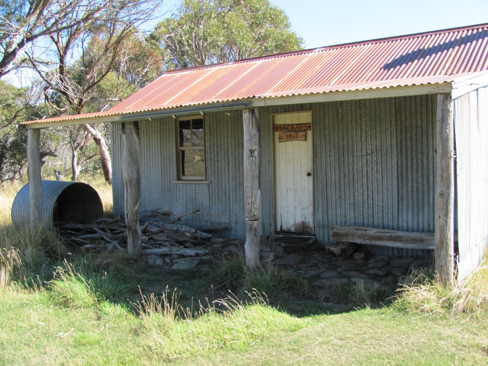 |
| Is that a footpad or a water race | 1 View to Tumut River from 1400m contour | 2 Walking the unmarked track S towards Doubtful Gap with Mt Jagungal getting closer | Unmarked track joins Grey Mare Fire Trail (AAWT) | 3 Mackays Hut |
Day 2
As I said, a lovely hut which escaped the 2003 fires. It's history by KHA here ![]() . Very pretty area in the morning light.
. Very pretty area in the morning light.
 |
 |
| Gums in morning light at Mackays Hut | Remnants of grazing near Mackays Hut |
We left at 8.25am and headed down the track to cross Tibeaudo Creek and turn S up its right bank. A truly beautiful area, first with little cascades, then opening out into wider flats. Our next check point was the watershed at the top of the creek, marked as the Great Dividing Range on the bottom of the Toolong map.
 |
 |
 |
 |
| View up Tibeaudo Creek at about 1600m contour | 4 Pool in Tibeaudo Creek | Heading to the top of Tibeaudo Creek | Views at the top of Tibeaudo Creek |
Continuing SE over the gentle crest, we headed down into a creek line. Distant views to what appeared to be a hut. As we got closer, it turned out to be a DFIR, like the one by the Grey Mare Trail N approach to Mt Jagungal. Another interesting feature was a track, unmarked on the map (except for an easement). We joined it at the creek, up a hill and through a gate at UTM 55H 633072-6001573 (GDA94). This took us (including a short detour to visit the DFIR) up to join the map marked Snowy Plains fire trail (still on private property) at UTM 55H 633028-6000165 (GDA94) and so back to the KNP boundary at UTM 55H 632361-5999694 (GDA94). See day 2, map 2 above. 2.8km in 1hr (included a couple of breaks and talking with the Snowy Hydro guys) on this track. Again, saved time walking off-track. However, I couldn't in all conscience recommend this route, as we did not have permission to enter the private land.
Cesjacks Hut was having a regular ranger visit. They kindly allowed us to add our bits of rubbish to the bag they'd collected at the hut. KHA's entry for Cesjacks Hut here ![]() .
.
 |
 |
 |
 |
| Unmarked track leading into private property | Nearly legal again | Snowy Plains fire trail leading to Cesjacks Hut | Cesjacks Hut |
After morning tea and a quick look inside (Max was interested to see the air crash memorial plaque that he'd read about) we headed off-track across open country to the W. We crossed Doubtful Creek and wandered along to Jagungal Saddle. This leg 3.7km in around 1hr30mins. We let a (Rob H said later, probably copperhead) snake lie. A good place to have lunch at 12.50pm above the Saddle.
Lunch consumed, with Max dripping more honey on the granite than on his Saos, we continued to the W up onto the Toolong Range and across the source of the Geehi River towards the knolls E of Mt Jagungal. Views opened up S to the Main Range.
 |
 |
 |
 |
| Heading W from Cesjacks Hut to cross Doubtful Creek | 5 Let sleeping snakes lie approaching Jagungal Saddle | Jagungal Saddle from lunch day 2 | View to the Main Range from E of Mt Jagungal |
At last the concrete marker on Mt Jagungal became apparent, each of the previous knolls fooled me. We dropped our bags around 400m E of the summit, at the top of the high line down the creek to the met station. It was 2.25pm. We reached the top at 2.35pm and enjoyed 15mins of the wonderful view.
Returning to our gear, we knew that most of day 2 was done, except the descent and fire trail to O'Keefes Hut. Max kept us high out of the creek - in places there is a recognisable footpad, a cairn or two, down in the trees it becomes braided and indistinct. We could see the SnowyHydro guys down at the DFIR and planned to give them a surprise, but they'd gone by the time we arrived. 2.1km in 33mins from the met station to O'Keefes Hut. KHA's entry here ![]() . Water to the E along the well worn footpad. Another comfortable night, this time just we two. Left a message in the log book for Kaz and party who will be along on their AAWT from Walhalla to Tharwa in mid-April.
. Water to the E along the well worn footpad. Another comfortable night, this time just we two. Left a message in the log book for Kaz and party who will be along on their AAWT from Walhalla to Tharwa in mid-April.
 |
 |
 |
 |
| Approaching Mt Jagungal from the E | 6 View S from Mt Jagungal marker | View E from Mt Jagungal to where we left our packs | Mt Jagungal from the met station on Grey Mare Fire Trail |
Day 3
Packed up and away by 8.30am.A 2km wander along the Grey Mare fire trail to where Bogong Creek crosses it, flowing down from Jugungal Saddle and Jackys Lookout to join the Tumut River. Very pretty. On up to the junction with the Farm Ridge trail and a look at the hut site and yards nearby. After I got back, a very speedy response to my enquiry via the HKA website as to this site's name - it is Rials Homestead ruin. KHA entry here ![]() .
.
 |
 |
|
| 7 Bogong Creek crosses Grey Mare Fire Trail | Remnants of yards near hut site near junction of Grey Mare and Farm Ridge fire trails |
A stretch of 8.4km in 2hrs along the Farm Ridge trail to the Tumut River. Very pleasant in the grassed and unburnt areas. There was a comment in a log book that it was not much good for bike riding!
 |
 |
 |
 |
 |
| Walking Farm Ridge Fire Trail | 8 View back to Mt Jagungal from Farm Ridge Fire Trail | View W from Farm Ridge Fire Trail | 9 Round Mountain from start of descent from Farm Ridge Fire Trail | Tumut River from descent of Farm Ridge Fire Trail |
We forded the river, rebooted and wandered up the Round Mountain trail, past Round Mountain Hut. KHA details here ![]() .
.
 |
| Round Mountain Hut |
An excellent circuit thank you Max. Perfect weather. Paddy would have been proud of us. Nice to be able to use our seniors cards at the accommodation. Pity about the busted rib.
Distance: 52.6km Climb:1700m. Time: 3 days
Grading: L/M-R; M(11)
KMZ file for Google Earth/Maps: PP round Mt Jagungal
Back to Walks Index
This page last updated 15Aug22