


26 April 2011 Another try for ... Sentry Box from the SE
Maps: Yaouk and Shannons Flat 1:25000
Getting There
This walk was organised and led by me as an irregular CBC Tuesday walk:
Tuesday 26 April - Another try for ... Sentry Box from the SE - L/M-R,ptX. We didn't make it last time, so this time another long, quick insert via the Settlers Track and new Grassy Creek fire trail to the Scabby Range NR. An assault up the SE spur, picking up the last 18 border markers to Sentry Box Mountain and beyond to Sentry Box Rock if time allows. A long day, around 30km and 700m climb. Maps: Yaouk and Shannons Flat. Leader: John Evans - jevans@pcug.org.au, (h) 6288 7235. Transport: ~$10 per person.
Further Information
On 15 Mar 11 we did 25km and 450m climb in 6hrs 45mins. On 26 Apr 11, sunrise is at 6.36am and sunset at 5.27pm. So we have 11hrs daylight. We also have the old fire trail track in the Scabby Range NR, so the 1.6km going up it will be faster this time, plus no border markers to search for until the last attempt's lunch spot. So it might be achievable.
I estimate 10hrs 15mins of walking. So we leave town at 6am. Meet time/place is: Kambah Shops, cnr Drakeford Dr and Marconi Cres, opposite Woolies pertrol, at 6am for 7 of us; KW at Lanyon.
Pomes (sic) are in the air at the moment. Adam L's request to join the party arrived as:
If i asked really nice
And then begged once or twice
Could I possibly go on this walk?If the answer was 'yes'
Then I'd shout out 'god bless'
Plus I'd promise on hills not to talk!
Photographs
You can also access all photographs here.
Walk
| Track maps: thumbnails are active - click for a larger picture | |||||
|
|
|
|
|
|
| Track overview | Track 1 | Track 2 | Track 3 | Track 4 | Track 5 |
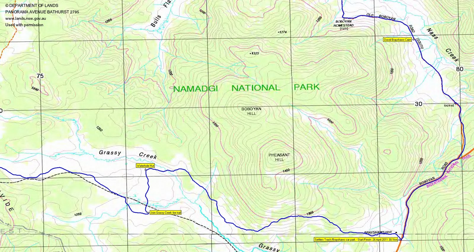
A swift 8.5km in 1hr 25mins (7mins quicker than last time!) from the Brayshaws Hut/Settlers Track car park in the Settlers Track to Waterhole Hut, S to the (original) Grassy Creek fire trail, up to the border to join the (new) Grassy Creek fire trail and to the major U-bend. From there, a further 2.1km on the old fire trail we'd found last time, generally up the border in the Scabby Range Nature Reserve. We were able to follow the old fire trail a little further than we were on it previously, and it took us to within a couple of hundred metres of L86.
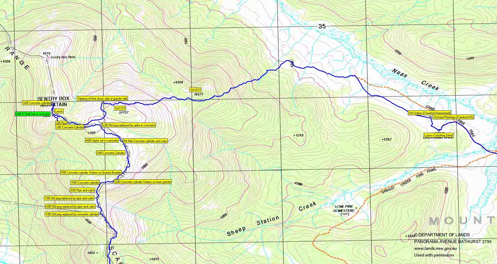
We continued on up the spur as quickly as we could towards the last border marker previously found, Y85. As the goal of today's walk was to reach Sentry Box, we quickly pressed on past X85 and W85 with the intention of reaching the summit and then border marker hunting on the return leg. But the pace could not be sustained, so I slowed it by beginning to hunt border markers. We first came upon V85, so will have to go back some time to pick up X85 and W85. Pushing on up through a couple of belts of tea-tree, we found U85, T85, S85 and R85. Between these two, fabulous views opened up back down to the Grassy Creek valley and round to the Yaouk Road. Found Q85.
P85, originally described as 'Concrete cylinder Station on Granite Boulder' was indeed that - rather magnificent.
At around O85 (which we found), huge granite slabs began to open up, heading towards the Sentry Box Mountain area. Quite different to my previous views of the area, just coming up from Lutons Crutching Shed in the N. There was no N85 border marker recorded in the original survey. The 54 Mile marker and M85 were easy to find. K85 is off the border line, a traverse mark so that Mouat could get a bearing to the Gudgenby trig.
In keeping with my new desire to learn to recognise plants, Alpine Grevillea (Grevillea alpina) was identified.
The Sentry Box Mountain area is a complex of tops. We first found L85 just above the 1700m contour on that unnamed top then, heading W, J85 and, down in the gully, I85. Struggling through the healthy tea-tree and heath, we finally made it to SH1696 and H85. It was now just before midday, so we settled down for lunch near a housey-cavey sort of affair with views all round. I popped a little way along the ridge towards Sentry Box Rock to pick up G85.
On the way in, I'd mentioned that I had an escape route generally E from the top down to Sams Creek fire trail, if we needed it. My intention had been to return the way we came in and pick up W85 and X85. But a mini-revolt resulted in the calling for a round, rather than an in and out the same way, so we left by first retracing our way through the gully, back to the 1700+m top and then towards SH1727.
Not wishing to go straight over the top, the choice was left or right round it. I chose left, which turned out to be probably the wrong call. We were soon funnelled down the side of a huge granite slab, heading further and further down towards the steep drainage line running NE off the tops. Monika (who is an excellent navigator) sorted me out by strongly suggesting that the bullet be bitten and we climb up onto the slab and regain its crest. This we did.
A mixture of granite, heath, then close and, finally more open, forest as we dropped 500+m over 2.5km via SH1577 to the Naas Creek valley and picked up Sams Creek fire trail. This leg took 1hr 30mins. More snaps of plants that I know, just to add to the record here.
We wandered down the valley, passing a magnificently coloured Candlebark, towards Lutons Crutching Shed. I had a couple of KHA marks near here - to make up for not getting W85 and X85. Now I've visited this location several times, but had never before even noticed the nearby orchard of exotic trees. There it was, with a nearby stone wall and site - KHA know it as 'Old Station (Crawford HS)'.
A look in LCS, then the long wander back along the Old Boboyan Road, past Boboyan Homestead, Davey Brayshaws cairn, through the Old Boboyan Road (South) trackhead and up the road to the cars.
An excellent trip to see another aspect of this hill. Thanks Adam L, Chris F, Ken W, Mark B, Monika B, Russ H and Phillip S.
Distance: 30.1km Climb: 800m. Time: 7.20am - 5.00pm (9hrs 40mins), with 50mins of stops.
Grading: L/M-R,ptX; H(14)
KMZ file for Google Earth/Maps: Sentry Box Mountain from the SE
Back to Walks Index
This page last updated 26Aug22