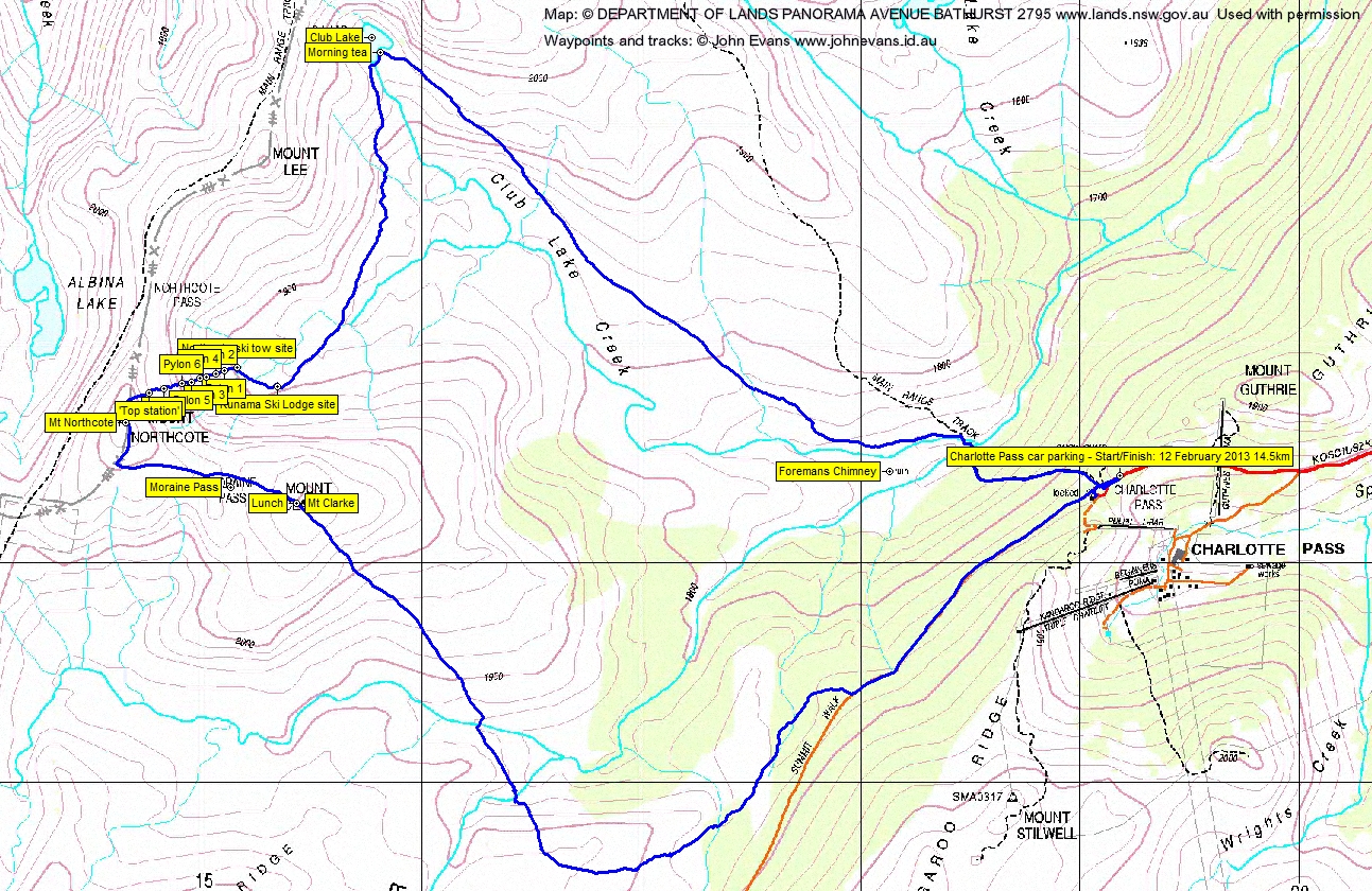
12 February 2013 Club Lake, Kunama Lodge site and Mt Clarke Kunama Lodge site Map: Perisher Valley 1:25000 Walk Description This walk was organised and led by Max S as an ad-hoc BBC Tuesday walk: Tuesday 12 February: Club Lake - M/M. From Charlotte Pass, down to Snowy R, follow Club Lake Ck to Club Lake, then Sth to try and locate the lodge ruin. Climb Mt Clarke to then head back to Charlotte Pass roughly following the Snowy R. Weather dependent. Leave Canberra about 6.30. Say 6 hrs walking/exploring plus pie time. Map: Perisher. Expression of interest would help planning. Max. 7 of us drove from Canberra to Charlotte Pass. Photographs Click here to access all walk photographs.Track Maps Track maps: thumbnails are active - click for a larger picture
Videos Google Earth Track Notes A terrific walk to new places for all of us. Perfectly organised by Max, except that the Jindabyne Bakery was closed for the day! A wallaby on the side of the road just after the start of the yellow lines reminded me to be cautious, so it was a hard job keeping up with Max's car. Sorted ourselves out and wandered down from Charlotte Pass to cross the Snowy River. Over Club Lake Creek we immediately turned off the track and generally paralleled the creek, some of the party higher and some lower, up to Club Lake. Adam had hairy tales of skiing and snow boarding down the cracks from Carruthers Peak. I've never been to Club Lake before - a very pretty spot. Morning tea + a successful search for a camera case. Next, back down Club Lake Creek a bit, then a bit of a contour along the bottom of Mt Lee to the creek that drains from Mt Northcote. Up it, again by high and low routes, to the grand ruin of the Kunama Ski Lodge. A beautiful situation; a sad tale, with a plaque "In Memory of Roslyn Twynam Wesche Kunama, 12th July, 1956". Killed by an avalanche. A substantial foundation remains. Looking about, we saw more ruins a little N of W about 350m away. Going over, we found the site of the Northcote Ski Tow. Here, Max gave us the flexibility to eather head for Mt Clarke, or climb up to the crest of the Main Range. Half the party did, Wayne doing an excellent job finding the pylons of the ski tow in the heath. The 'top station' had some substantial metal lying about. Thanks to some excellent sleuthing by Matthew Higgins, here's heaps of information about the Kunama Huette and Northcote Tow House:
I puffed to the top (the others ran and talked) and we took in the view down the other side to Lake Albina. Then via Mt Northcote and Moraine Pass to Mt Clarke for lunch. Rang home. From here it was mostly down hill. We crossed the arm of the Snowy River that rises at Rawson Pass, then over the foot of the Etheridge Ridge to cross the named arm of the Snowy River, huffed and puffed over a quite scrubby little spur and down to another site that Matthew was able to show us. Back up onto the Summit Walk and so to the cars. Summary Distance: 14.5km Climb: 620m. Time: 9.10am - 3.10pm (6hrs), with 1hr of breaks. Walk Participants Eric G, Matthew H, Maggie K, Adam L, Wayne P, Max S, me. Back to Walks Index This page last updated 2Sep22 |