Walking the Tarlo River
Tarlo River – M/R,X. An exploratory trip along ridges and creeks to the Tarlo River, then along the river past some large pools. The Tarlo River National Park, north of Goulburn, is rarely visited because access needs to be arranged through private property (which I have done). Probably 13 to 15 km, includes a climb of about 100 m and several undulations in the 30 to 50 m range. Probably fairly open forest on the ridges, possibly scrubby along the river – we’ll find out! Maps: Chatsbury and possibly Taralga. Leader: Linda G. Transport: $100 per car. A 1 hour 40 minute drive from Northbourne Ave. Limit: 3 cars.
Further Information
The Tarlo River National Park Plan of Management is at http://www.environment.nsw.gov.au/resources/parks/pomFinalTarlo.pdf .
Summary
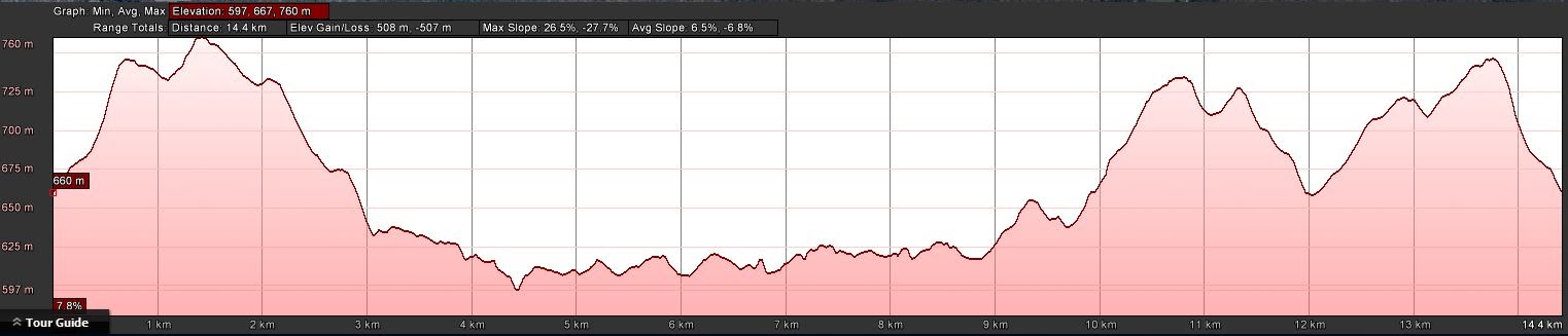
Distance: 14.6km | Climb: 500m | Time: 9.15am – 4.05pm (6hrs 50mins), including 1hr 5mins of breaks | Grading: M/R; M(11)
Photographs
Photographs are available, where you can start a large sized slideshow.
Video
Waypoint and Track Files
Download the .gpx file. (Right click, Save Link As…, Save – if you want to use it.)
To use in Google Earth, do File, Open… and select Gps or All files as the File Type.
Track Notes
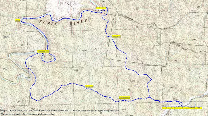
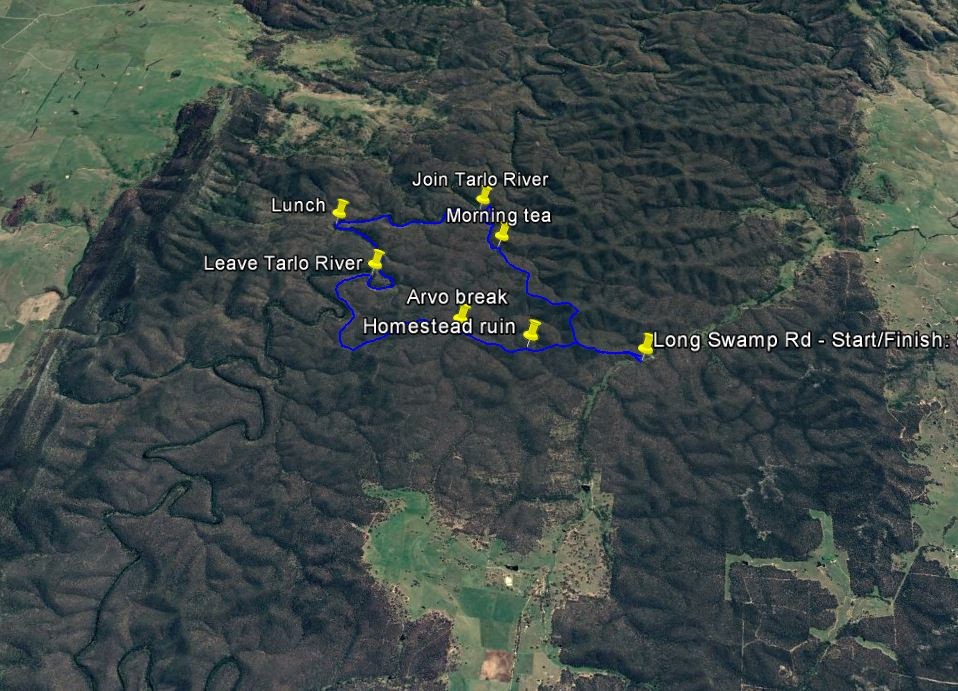
Left the Northbourne netball courts at 7.15am and started walking at 9.15am, so about a 1hr 45min drive. The last on not quite suitable for 2WD vehicle track through private property, Linda having done her homework and received permission for our crossing to the Tarlo River National Park boundary.
A short rise took us through easy walking, open woodland up to a ridge. We trended west, then north-west, picking up an old vehicle track or fire break alignment for some of the way. Pleasant walking to morning tea, the leg of 3.2km taking 1hr 10mins.
We then followed an unnamed creek for 1.3km in 35mins down to join the Tarlo River at a huge pool. The river drains farming land, so the water colour is a little green.
The next hour was a delightful 2.4km trip up the river on the true right bank. Lovely grassed terrances with an abundance of Lomandra (Mat Rush). A couple of clumps of stinging nettle – even after a description of the consequences of touching them, Ming took a quick swipe just to experience the sting! A couple of little waterfalls. Some little cliff-ettes on the other side.
A perfect spot or lunch beside the river. Eric propped up a giant Casuarina and I must confess I had a zizz.
Away at 1pm to do another bit 2.1km of the river in 55mins. We left the Tarlo at a big bend and climbed an open spur. Dry, open woodland on the tops with some grass trees. We took one last look down on the river from the top of a gorge area, then followed the wrinkly ridges to another creek line for a short afternoon tea break.
Our route had been following a faint easement marked on the map. Climbing out from afternoon tea, in another km we came upon an old homestead site. It’s mentioned in the Management Plan, but nothing is know about it.
Some more ups and downs, a little fire trail (not marked on my digital edition of the Chatsbury map), onto the old vehicle track alignment and along a final ridge, then down to the cars. From leaving the Tarlo River, our return leg was 5.7km in 2hrs 10mins.
As always, a great trip with this leader. Excellent day!
Track Maps
Track
Profile
Google Earth snip
Party
9 walkers – Peter C, Philip G, Eric G, Linda G (leader), Ian H, Ming L, David W, Ian W, me.