TRAVELLING THE AUSTRALIAN
ALPS WALKING TRACK

|
TRAVELLING THE AUSTRALIAN |
|
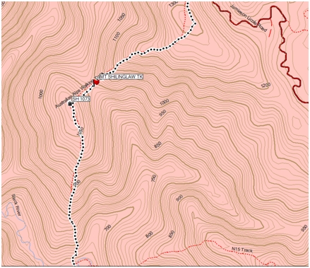
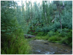
| A combination of thick regrowth, an indistinct track and steep slopes presents a navigational challenge when climbing from the Black River to Mt Shillinglaw (Vic). | You can always count on your fellow bushwalkers to give assistance...this was scratched onto the burnt trunk of a tree...a welcome sight encountered climbing out of the Black River! |
Introduction
In March-April 2010 I led a group of walkers from the Canberra Bushwalking Club along the Australian Alps Walking Track. I was fortunate in having a fit and knowledgeable party of bushwalkers to accompany me (at various stages), comprising Mark Riley, Amanda Matley, Peter Jones, Madeleine Baldwin, Mike Baker, and Rene Davies.
For me it marked a milestone, as it was only 2 years previously that as a fairly green bushwalker. I did the same walk under the leadership of Rob Horsfield - a recognised expert on the track. It was an overwhelming experience, such that it was only after having undertaken a number of subsequent extended walks with Rob and engaging in regular bushbashing with John Evans and Max Smith that I felt up to the challenge of leading a walk on the AAWT.
Purpose of this material
The purpose of this material is to assist others preparing to walk the AAWT by:
Warning
|
 |
Summary of Track
|
| (1) Name of Track segment for each day (gpx file) (kml file) (Daily photos - track from Garmin MapSource, vertical profile, terrain and views) |
(2) Grid Reference of campsite at the end of each day (GDA MGRS) |
(3) Daily Distance (km) |
(4) Daily hours walking (includes breaks) |
(5) Average speed (including breaks) k/hr |
(6) Approx Daily Ascent (m) (see vertical profile in daily photos) |
(7) Approx Daily Descent (m) (see vertical profile in daily photos) |
(8) Summary of difficulty of terrain (where 5 = easy) (see terrain in daily photos) |
(9) Views (1-5) where 5=great (see views in daily photos) |
(10) Terrain Type Navigational Challenges |
(11) Facilities at camp (W=Water) |
(12) Elevation of campsite (m) |
(13) Comments |
(14) Scanned PDF maps for each day (link to Google docs to come) |
| Day 01 Walhalla-O'Sheas gpx kml Day01 photos |
55HDU45895 02356 | 13.4 | 5:06 | 3 | 360 | 335 | 4 | 2 | Track | Table, W, groceries at Walhalla | 377 | 1 | |
| Day 02 O'Sheas - St Gwinear gpx kml Day02 photos |
55HDU39054 11682 | 20.1 | 8:28 | 2 | 1335 | 220 | 3 | 5 | Track with long ascent | Rock shelter, W | 1490 | Rock shelter | 1,2 |
| Day 03 St Gwinear - Stronachs gpx kml Day03 photos |
55HDU30944 21927 | 17.7 | 7:45 | 2 | 310 | 655 | 2 | 3 | Track/pad/FT Waist high overgrown heath after Mt St Phillack |
W | 1117 | 2,3 | |
| Day 04 Stronachs - Red Jacket gpx kml Day04 photos |
55HDU37977 32185 | 21.8 | 9:29 | 2 | 765 | 1410 | 2 | 2 | Track/FT with long, steep descents & pick up sticks before Little Easton | W | 509 | 3,4,5 | |
| Day 05 Red Jacket - Black River gpx kml Day05 photos |
55HDU47016 45321 | 26.0 | 10:12 | 3 | 1250 | 1135 | 2 | 2 | Track/FT with long, steep descents | W | 629 | Travelled on Champion Spur Link Tk & took short cut over Mt Singleton. Note slight mis navigation prior to Mt Victor as lost each other on FT! | 6,7,8,9 |
| Day 06 Black R - Mt Skene (above Rumpff Saddle) gpx kml Day06 photos |
55HDU46343 56720 | 14.9 | 8:03 | 2 | 1240 | 565 | 1 | 4 | FT/Track bushbash near knoll SW of Shillinglaw |
1544 | Water at Rumpff Saddle | 9,10,11 | |
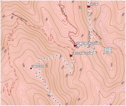
| Day 07 Mt Skene - Low Saddle gpx kml Day07 photos |
55HDU50596 68056 | 17.5 | 9:30 | 2 | 715 | 1110 | 2 | 3 | FT/Track bushbash NE of Mt Sunday with hard slog through dense regrowth |
922 | 11,12,13 | ||
| Day 08 Low Saddle - E Barkly Rd gpxkmlDay08 photos |
55HDU55389 73380 | 12.4 | 9:08 | 1.3 | 815 | 440 | 3 | 5 | Track/pad & long descent | 1290 | Went off track to find W | 13,14 | |
| Day 09 E Barkly Rd - Chester Yd gpx kml Day09 photos |
55HDU64199 78772 | 15.3 | 10:09 | 1.5 | 855 | 645 | 2 | 5 | Track/pad with steep descent. Note: easier going over the top of Sqaure Top than sidling it | W | 1491 | 15,16 | |
| Day 10 Chester Yd - Vallejo Gantner H gpx kml Day10 photos |
55HDU70722 85990 | 13.8 | 7:52 | 2 | 885 | 535 | 3 | 5 | FT/easy bushbash up King Billy/ pad/track | Hut, W, Toilet | 1589 | Side trip off the AAWT | 16,17 |
| Day 11 Vallejo Gantner H - Catherine Saddle gpx kml Day11 photos |
55HDU69827 92384 | 10.2 | 7:04 | 1.4 | 540 | 1070 | 3 | 5 | Pad along ridge line, scramble | W | 1208 | 17,18,19, 20 | |
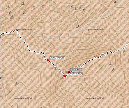
| Day 12 Catherine Saddle - Barry Saddle gpx kml Day12 photos |
55HDU79022 92949 | 12.3 | 10:53 | 1.1 | 935 | 1200 | 1 | 5 | Pad, track up Mt Despair indistinct, pick up sticks at Viking Saddle, confusing coming off Viking summit |
Water Tank | 960 | Water tank full, but dark black. Tasted OK | 18,19,20 |
| Day 13 Barry Saddle - S Selwyn gpx kml Day13 photos |
55HDU90118 99001 | 16.2 | 7:34 | 2 | 1130 | 840 | 4 | 3 | Pad /old FT - a day of up and down | Water tank on way | 1238 | Water tank along the way still without a roof, but 1/2 full and clean | 20,21 |
| Day 14 S Selwyn - Murrays H site gpx kml Day14 photos |
55HDV99669 00199 | 15.2 | 6:57 | 2 | 950 | 800 | 4 | 3 | Old FT | 1410 | 21,22 | ||
| Day 15 Murrays H Site - Diamantina H gpx kml Day15 photos |
55HEV10953 07746 | 16.8 | 5:37 | 3 | 1215 | 905 | 4 | 2 | Track/bitumen road | Hut, groceries at Hotham | 1735 | Note only walked 10km..hitched a lift to hut | 23,24 |
| Day 16 Diamantina H - Cope H gpx kml Day16 photos |
55HEV26019 15452 | 23.3 | 9:35 | 2 | 640 | 670 | 4 | 3 | Track | Hut,W, Toilet | 1684 | Went off AAWT to visit Mine | Bogong Alpine Area &24,25 |
| Day 17 Cope H - Ropers H gpx kml Day17 photos |
55HEV29550 26129 | 17.2 | 4:43 | 4 | 360 | 310 | 5 | 3 | FT | Hut, W, Toilet | 1712 | Note: GPS batteries died midway, hence straight line on profile | 25,26 |
| Day 18 Ropers H - Cleve Cole H gpx kml Day18 photos |
55HEV29227 32151 | 11.4 | 7:47 | 1.4 | 780 | 790 | 4 | 3 | Track | Hut, W, Toilet | 1734 | ||
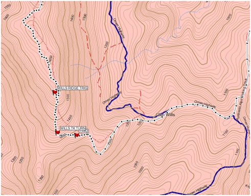
| Day 19 Cleve Cole H - Mt Willis H gpx kml Day19 photos |
55HEV42288 25943 | 18.6 | 8:26 | 2 | 915 | 855 | 3 | 5 | Track/FT | Hut, Water tank, Toilet | 1739 | Note in Mt Wills log book: If the tank is empty there is a water supply 15 mins from the Hut. Walk down the track in direction of Mt Bogong fo 10 mins to saddle with concrete culvert under the track. (ie. At bottom of first steep descent, on the left is a boulder with cairn on it) Then , take a bearing of 260degrees (doesn't say TN or MN) and after 2 minutes you'll merge with a gully on your left. Follow gully down for another couple of minutes and you'll see yellow tape on a small dead tree. Nearby a piece of polypipe has good water. | |
| Day 20 Mt Wills H - Horsfield C gpx kml Day20 photos |
55HEV52822 23225 | 20.5 | 10:33 | 2 | 471 | 1176 | 1 | 2 | Track/bushbash & pick up sticks coming off Mt Wills /FT long climb out of Gill Ck | 1069 | Camped on side of firetrail with "campsite" christened in honour of Rob | 27,28 | |
| Day 21 Horsfield C - Mitta Mitta R gpx kml Day21 photos |
55HEV58888 24182 | 8.2 | 3:10 | 3 | 10 | 554 | 5 | 2 | FT/Track | W | 502 | 28 | |
| Day 22 Mitta Mitta R - Beloka R gpx kml Day22 photos |
55HEV67273 28879 | 16.2 | 9:42 | 2 | 1041 | 270 | 2 | 3 | Track/pad | W | 1173 | Picked up W at Stony Ck to lessen amount had to carry up from the Mitta. Would make a good RV point | 29 |
| Day 23 Beloka R - Buenba Ck gpx kml Day23 photos |
55HEV79435 37502 | 19.6 | 9:40 | 2 | 521 | 833 | 3 | 3 | Track/pad | W | 827 | 30,31 | |
| Day 24 Buenba Ck - Buckwong Ck gpx kml Day24 photos |
55HEV89717 32709 | 18.3 | 8:44 | 2 | 615 | 250 | 3 | 3 | Track/FT | W | 1110 | 32 | |
| Day 25 Buckwong Ck - Limestone Ck gpx kml Day25 photos |
55HEV95664 23629 | 15.9 | 9:52 | 2 | 670 | 855 | 3 | 3 | Track | W | 940 | 33a,33b | |
| Day 26 Limestone Ck - Cowombat Flat gpx kml Day26 photos |
55HFV04651 27251 | 21.9 | 10:45 | 2 | 785 | 535 | 2 | 3 | Track/FT | W | 1168 | 33b,34 | |
| Day 27 Cowombat Flat - Cascade FT gpx kml Day27 photos |
55HFV10750 41642 | 21.6 | 9:28 | 2 | 460 | 330 | 5 | 3 | FT | W | 1293 | 34,35 | |
| Day 28 Cascade FT - Dead Horse Gap gpx kml Day28 photos |
55HFV13000 56811 | 20.7 | 7:46 | 3 | 675 | 350 | 5 | 3 | FT | W, groceries at Thredbo | 1646 | 35,36 | |
| Day 29 DHG - N Mt Twynum gpx kml Day29 photos |
55HFV18250 72126 | 20.2 | 8:28 | 2 | 965 | 645 | 4 | 5 | Track | W | 2108 | 37,38,39,40,41 | |
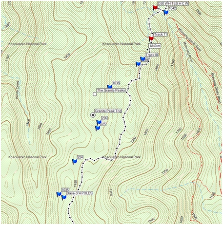
| Day 30 N Mt Twynum - Whites R H gpx kml Day30 photos |
55HFV24429 81902 | 14.5 | 7:16 | 2 | 320 | 480 | 2 | 5 | Track/Pad/Rolling Grounds challenge | Hut, W, Toilet | 1714 | 41,42,43 | |
| Day 31 Whites R H - O'Keefe H gpx kml Day31 photos |
55HFA26191 01385 | 30.6 | 11:07 | 3 | 640 | 730 | 5 | 3 | FT | Hut, W, Toilet | 1630 | 43,45,46,47,48,49,50 | |
| Day 32 O'Keefe H - Happy H gpx kml Day32 photos |
55HFA38727 13663 | 26.4 | 9:09 | 3 | 500 | 600 | 5 | 3 | FT | Hut, W | 1513 | Slightly off the AAWT | 50,51,52,53,54 |
| Day 33 Happy H - 4 Mile H gpx kml Day33 photos |
55HFA33364 22832 | 14.5 | 6:03 | 2 | 350 | 350 | 3 | 3 | Pad/FT/Track | Hut, W, Toilet | 1473 | 54,55,56 | |
| Day 34 4 Mile H - Witses H gpx kml Day34 photos |
55HFA43054 35789 | 20.3 | 7:08 | 3 | 455 | 560 | 4 | 3 | Track/FT | Hut, W, Toilet | 1393 | 56,57,58,59,60 | |
| Day 35 Witses H - Hainsorth H gpxkmlDay35 photos |
55HFA44929 51347 | 22.3 | 8:07 | 3 | 400 | 430 | 4 | 3 | FT/track/pad near old telegraph poles | Hut, W | 1355 | 60,61,62,63,64 | |
| Day 36 Hainsworth H - Dunn's Flat gpx kml Day36 photos |
55HFA60866 50417 | 23.7 | 8:01 | 3 | 545 | 480 | 4 | 4 | FT | W | 1418 | 64,65,66,67 | |
| Day 37 Dunn's Flat - Orroral R gpx kml Day37 photos |
55HFA76691 56405 | 22.4 | 8:55 | 2 | 480 | 910 | 3 | 4 | FT/Track/Pad Confusing at Pond Ck Flats | W | 922 | 67,68,69 | |
| Day 38 Orroral R - Namadgi Info Centre gpx kml Day38 photos |
55HFA87234 66028 | 21.9 | 6:57 | 3 | 810 | 1120 | 4 | 5 | FT/Track | W, Toilet, Information | 600 | 69,70,71 | |
you can also download this table from here. please report any failed links by email |
|||||||||||||
Navigational Challenges
|
|
||||||
|
|
||||||
|
|
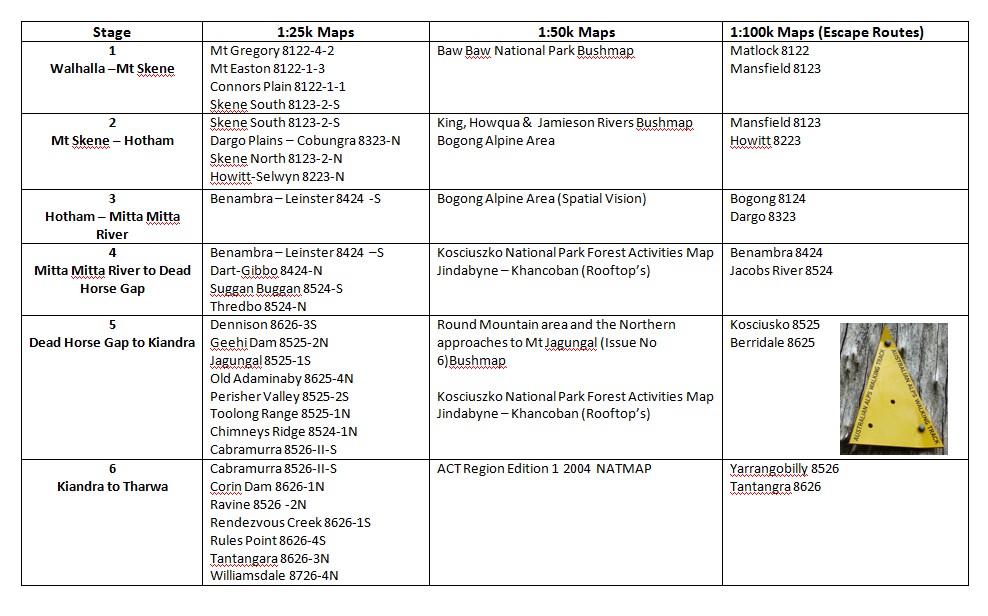
AAWT Map List
Other Supporting Material
You should read “Australian Alps Walking Track” Fourth Edition 2009 by John & Monica Chapman, John Siseman ISBN 978 1 920995 06 5
I have also provided:
This page last updated 29Jul10